Penhold is a town in central Alberta, Canada. Penhold is surrounded by Red Deer County, 16 km (9.9 mi) south of Red Deer at the junction of Highway 2A and Highway 42. It is located 128 kilometres (80 mi) north of Calgary, east of the Red Deer River.

Foothills County is a municipal district in southern Alberta, Canada adjacent to the south side of Calgary in Census Division No. 6. Despite sharing a common border with the City of Calgary, it does not form part of the Calgary census metropolitan area (CMA) as defined by Statistics Canada. It is however a member municipality of the Calgary Metropolitan Region Board.

Athabasca County is a municipal district in north central Alberta, Canada. It is located northeast of Edmonton and is in Census Division No. 13. Prior to an official renaming on December 1, 2009, Athabasca County was officially known as the County of Athabasca No. 12.

Torrington is a hamlet in central Alberta, Canada within Kneehill County. It is located approximately 160 kilometres (99 mi) northeast of Calgary at the junction of Highway 27 and Highway 805.

Division No. 11 is a census division in Alberta, Canada. Surrounding the City of Edmonton, the majority of the division comprises Alberta's Capital Region, while the western and southern portions of the division are located within central Alberta. The division also forms the northern segment of the Calgary–Edmonton Corridor.
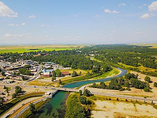
High River is a town within the Calgary Metropolitan Region of Alberta, Canada. It is approximately 68 kilometres (42 mi) south of Calgary, at the junction of Alberta Highways 2 and 23. High River had a population of 14,324 in 2021.

Chestermere, originally named Chestermere Lake, is a city in the Canadian province of Alberta, within Rocky View County. It is largely a commuter town of Calgary and is a member municipality of the Calgary Region. The city, which surrounds Chestermere Lake, was known as Chestermere Lake from 1977 to 1993.
Division No. 3 is a census division in Alberta, Canada. It is located in the southwest corner of southern Alberta and its largest urban community is the Town of Claresholm.
Division No. 5 is a census division in Alberta, Canada. It is located in the north-central portion of southern Alberta and its largest urban community is the Town of Strathmore.
Division No. 8 is a census division in Alberta, Canada. It is located in the south-central portion of central Alberta and includes the City of Red Deer and surrounding areas. The division forms the central segment of the Calgary–Edmonton Corridor. Division No. 8 is the smallest census division in Alberta according to area.
Division No. 13 is a census division in Alberta, Canada. The majority of the division is located in the north-central portion of central Alberta, while the northeast portion of the division is located within northern Alberta. The division's largest urban community is the Town of Whitecourt.

Donnelly is a village in northern Alberta, Canada within the Municipal District of Smoky River No. 130. It is located near the intersection of Highway 2 and Highway 49, located approximately 65 km (40 mi) south of Peace River and 427 km (265 mi) northwest of Edmonton.

The Municipal District of Acadia No. 34 is a municipal district (MD) in southern Alberta, Canada, east of Calgary, close to the Saskatchewan border, in Census Division No. 4.

The Municipal District of Bighorn No. 8 is a municipal district (MD) situated in Census Division No. 15 of Alberta, Canada. It is located between Calgary and Banff National Park, north of Kananaskis Improvement District. Highway 1 passes through the municipal district.
Keoma is a hamlet in southern Alberta under the jurisdiction of Rocky View County.

Kneehill County is a municipal district in central Alberta, Canada within Census Division No. 5.
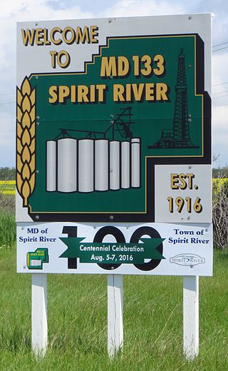
The Municipal District of Spirit River No. 133 is a municipal district (MD) in northwest Alberta, Canada, north of Grande Prairie. Located in the Upper Peace Region, its municipal office is located in the Town of Spirit River. With an area of 683.6 km2 (263.9 sq mi), it is the smallest municipal district in Alberta.
Cayley is a hamlet in southern Alberta, Canada within the Foothills County. It is also recognized as a designated place by Statistics Canada.
Nightingale is a hamlet in southern Alberta, Canada within Wheatland County. It is located 4 kilometres (2.5 mi) west of Highway 21, approximately 53 kilometres (33 mi) east of Calgary.

In the 2021 Census, the City of Calgary had a population of 1,306,784 residents, representing 30.7% of the 4,262,635 residents in all of Alberta, and 3.5% compared to a population of 36,991,981 in all of Canada. The total population of the Calgary census metropolitan area (CMA) was 1,481,806. Calgary is the largest city in Alberta, and the third-largest municipality and fifth-largest metropolitan area in Canada, as of 2021.
