
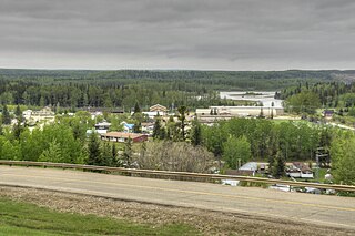
Whitecourt is a town in Northern Alberta, Canada that is surrounded by Woodlands County. It is approximately 177 km (110 mi) northwest of Edmonton and 279 km (173 mi) southeast of Grande Prairie at the junction of Highway 43 and Highway 32. It has an elevation of 690 m (2,260 ft).

Barrhead is a town in central Alberta, Canada that is surrounded by the County of Barrhead No. 11. It is located along the Paddle River and at the intersection of Highway 33 and Highway 18, approximately 120 km (75 mi) northwest of the City of Edmonton. It is also located along the route of the Express Trail, used by the North West Company, which was originally a First Nations trail. The trail was later widened by George Simpson and John Rowand to save the North West Company over $5,000.

Athabasca County is a municipal district in north central Alberta, Canada. It is located northeast of Edmonton and is in Census Division No. 13. Prior to an official renaming on December 1, 2009, Athabasca County was officially known as the County of Athabasca No. 12.

Division No. 11 is a census division in Alberta, Canada. Surrounding the City of Edmonton, the majority of the division comprises Alberta's Capital Region, while the western and southern portions of the division are located within central Alberta. The division also forms the northern segment of the Calgary–Edmonton Corridor.
Fort Assiniboine is a hamlet in northwest Alberta, Canada, within Woodlands County. It is located along the north shore of the Athabasca River at the junction of Highway 33 and Highway 661. It is approximately 39 kilometres (24 mi) northwest of Barrhead, 62 kilometres (39 mi) southeast of Swan Hills and 91 kilometres (57 mi) northeast of Whitecourt.
Division No. 8 is a census division in Alberta, Canada. It is located in the south-central portion of central Alberta and includes the City of Red Deer and surrounding areas. The division forms the central segment of the Calgary–Edmonton Corridor. Division No. 8 is the smallest census division in Alberta according to area.

Swan Hills is a town in northern Alberta, Canada. It is in the eponymous Swan Hills, approximately 80 km (50 mi) north of Whitecourt and 62 km (39 mi) northwest of Fort Assiniboine. The town is at the junction of Highway 32 and Grizzly Trail, and is surrounded by Big Lakes County.

Valleyview is a town in northwest Alberta, Canada. It is surrounded by the Municipal District of Greenview No. 16 and in Census Division No. 18.

Westlock is a town in central Alberta, Canada. Founded in 1913, the town is primarily an agricultural, business, and government administration centre serving communities and rural areas within surrounding Westlock County.
Clyde is a village in northern Alberta, Canada. It is located north of Edmonton and east of Westlock, near the junction of Highway 18 and Highway 2.

Westlock County is a municipal district in central Alberta, Canada that is north of Edmonton. The county was formerly known as the Municipal District of Westlock No. 92, and was created in 1943 from the merger of five smaller municipal districts.
The County of Barrhead No. 11 is a municipal district in north central Alberta, Canada. It is located northwest of Edmonton and is in Census Division No. 13.
Blue Ridge is a hamlet in northwest Alberta, Canada within Woodlands County. It is located on Highway 658, 7 kilometres (4.3 mi) north of Highway 43 and 3 kilometres (1.9 mi) south of the Athabasca River. It is midway between the towns of Whitecourt and Mayerthorpe and approximately 159 kilometres (99 mi) northwest of Edmonton.

Woodlands County is a municipal district in north-central Alberta, Canada. Located in Census Division No. 13, its municipal office is located outside but adjacent to the Town of Whitecourt. A second municipal office is located in the Hamlet of Fort Assiniboine.

The Municipal District of Lesser Slave River No. 124 is a municipal district (MD) in north-central Alberta, Canada. Its municipal office is located in the Town of Slave Lake. Located in Census Division 17, the MD takes its name from Lesser Slave River, which drains Lesser Slave Lake into the Athabasca River.
Calling Lake is a hamlet in northern Alberta, Canada within the Municipal District of Opportunity No. 17. It is located on Highway 813 along the eastern shore of Calling Lake, immediately north of Calling Lake Provincial Park. It is approximately 59 km (37 mi) north of Athabasca and 113 km (70 mi) south of Wabasca and has an elevation of 595 m (1,952 ft).
Larkspur is a summer village in Alberta, Canada. It is located north of Westlock and south of Athabasca, east of Highway 44 and west of Highway 2.
Jarvie is a hamlet in central Alberta, Canada within Westlock County. It is located 0.6 kilometres (0.37 mi) west of Highway 44, approximately 108 kilometres (67 mi) northwest of Edmonton. Jarvie is on the bank of the Pembina River, with the Canadian Northern Railway directly east to the townsite. In June 2020, the Jarvie General Store was destroyed by a fire, the store had been in operation for at least 110 years.
White Gull is an unincorporated community in northern Alberta, Canada within Athabasca County. It is 1 kilometre (0.62 mi) west of Highway 2, approximately 138 km (86 mi) north of Edmonton.

Athabasca-Barrhead-Westlock is a current provincial electoral district in Alberta, Canada. The district is one of 87 districts mandated to return a single member (MLA) to the Legislative Assembly of Alberta using the first past the post method of voting. It was contested for the first time in the 2019 Alberta election.
