Onoway

Last updated • 1 min readFrom Wikipedia, The Free Encyclopedia
Onoway
Town
Town of Onoway
Onoway sign.jpg
Welcome sign
Nickname: 
Hub of the Highways
0240 Town Onoway, Alberta Locator.svg
Location in Lac Ste. Anne County
Alberta County Point Locator.svg
Red pog.svg
Onoway
Location within Alberta
Coordinates: 53°42′04″N114°11′53″W / 53.70111°N 114.19806°W / 53.70111; -114.19806
CountryCanada
Province Alberta
Planning region Upper Athabasca
Municipal district Lac Ste. Anne County
Incorporated [1]  
   Village June 25, 1923
   Town September 1, 2005
Government
[2]
  MayorLen Kwasny
  Governing bodyOnoway Town Council
   MP Dane Lloyd
   MLA Shane Getson
Area
 (2021) [3]
  Land3.31 km2 (1.28 sq mi)
Population
 (2021) [3]
  Total966
  Density292.1/km2 (757/sq mi)
Time zone UTC−7 (MST)
  Summer (DST) UTC−6 (MDT)
Postal code span
Area code -1+780 -1+587
Highways Highway 43
Highway 37
Waterway Lac Ste. Anne
Sturgeon River
Website Official website

Onoway is a small town in central Alberta, Canada. It is approximately 60 km (37 mi) northwest of Edmonton at the junction of Highway 37 and Highway 43. The mayor is Len Kwasny. [4]

Contents

History

Two theories are behind the naming of the community. "Onoway" in Chipewyan translates to "fair field" while the variant "onaway" is used in The Song of Hiawatha , a poem by Henry Wadsworth Longfellow. [5] Onoway's post office was established in 1904. [6] Onoway incorporated as a village on June 25, 1923. [1] It incorporated as a town on September 1, 2005. [1]

Geography

The Canadian National Railway tracks run through the town, which is situated east of Lac Ste. Anne and south of the Sturgeon River.

Demographics

In the 2021 Census of Population conducted by Statistics Canada, the Town of Onoway had a population of 966 living in 360 of its 388 total private dwellings, a change of

In the 2016 Census of Population conducted by Statistics Canada, the Town of Onoway recorded a population of 1,029 living in 355 of its 374 total private dwellings, a

Attractions

Onoway hosts a weekend fair every June called "Heritage Days".[ citation needed ] [8]

Education

Onoway has an elementary school, serving 400 students in the local area [9] as well as a junior and senior high school which has been open since the 1940s. [10]

See also

Related Research Articles

<span class="mw-page-title-main">Beaumont, Alberta</span> City in Alberta, Canada

Beaumont is a city adjacent to Leduc County within the Edmonton Metropolitan Region of Alberta, Canada. It is at the intersection of Highway 625 and Highway 814, adjacent to the City of Edmonton and 6.0 kilometres (3.7 mi) northeast of the City of Leduc. The Nisku Industrial Park and the Edmonton International Airport are 4.0 kilometres (2.5 mi) to the west and 8.0 kilometres (5.0 mi) to the southwest respectively.

<span class="mw-page-title-main">Division No. 13, Alberta</span> Census division in Alberta, Canada

Division No. 13 is a census division in Alberta, Canada. The majority of the division is located in the north-central portion of central Alberta, while the northeast portion of the division is located within northern Alberta. The division's largest urban community is the Town of Whitecourt.

Bashaw is a town in central Alberta, Canada. It is at the junction of Highway 21 and Highway 53.

<span class="mw-page-title-main">McLennan, Alberta</span> Town in Alberta, Canada

McLennan is a town in northern Alberta, Canada. It is approximately 50 km (31 mi) north of High Prairie on Highway 2.

<span class="mw-page-title-main">Rainbow Lake, Alberta</span> Town in Alberta, Canada

Rainbow Lake is a town in northwest Alberta, Canada. It is west of High Level at the end of Highway 58, in Mackenzie County.

Sedgewick is a town in central Alberta, Canada. It is approximately 83 km (52 mi) east of Camrose at the junction of Highway 13 and Highway 869. The Canadian Pacific Kansas City railway runs through the town.

<span class="mw-page-title-main">Spirit River, Alberta</span> Town in Alberta, Canada

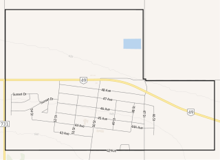
Spirit River is a town in northern Alberta, Canada. It is approximately 78 km (48 mi) north of Grande Prairie at the junction of Highway 49 and Highway 731.

<span class="mw-page-title-main">Two Hills, Alberta</span> Town in Alberta, Canada

Two Hills is a town in central Alberta, Canada. It is approximately 137 km (85 mi) east of Edmonton at the junction of Highway 45 and Highway 36. Two Hills is primarily an agriculture-based community. It was named from the presence of two hills located near the town. Post office established in 1914.

<span class="mw-page-title-main">Hines Creek</span> Village in Alberta, Canada

Hines Creek is a village in northern Alberta, Canada. It is located 67 km west of Grimshaw and 28 km north of Fairview, along Highway 64.

<span class="mw-page-title-main">Hythe, Alberta</span> Hamlet in Alberta, Canada

Hythe is a hamlet in northwest Alberta, Canada within the County of Grande Prairie No. 1. It is located on Highway 43 approximately 58 km (36 mi) northwest of the City of Grande Prairie and 73 km (45 mi) southeast of the City of Dawson Creek, British Columbia. It held village status prior to July 2021.

Linden is a village located in central Alberta, Canada that is surrounded by Kneehill County. It is located 28 km (17 mi) southwest of Three Hills and 26 km (16 mi) north of Beiseker.

<span class="mw-page-title-main">Rycroft, Alberta</span> Village in Alberta, Canada

Rycroft is a village in northern Alberta, Canada. It is approximately 68 km (42 mi) north of Grande Prairie and 7 km (4.3 mi) east of Spirit River. Dunvegan Provincial Park is located 20 km north of the community.

<span class="mw-page-title-main">Municipal District of Smoky River No. 130</span> Municipal district in Alberta, Canada

The Municipal District of Smoky River No. 130 is a municipal district (MD) in northwestern Alberta, Canada. Located in Census Division No. 19, its municipal office is located in the Town of Falher.

<span class="mw-page-title-main">Municipal District of Willow Creek No. 26</span> Municipal district in Alberta, Canada

The Municipal District of Willow Creek No. 26 is a municipal district (MD) in southern Alberta, Canada. Located in Census Division No. 3, its municipal office is located adjacent to Claresholm Industrial Airport, west of the Town of Claresholm.

<span class="mw-page-title-main">Vulcan County</span> Municipal district in Alberta, Canada

Vulcan County is a municipal district in Alberta, Canada. Located in Census Division No. 5, its municipal office is located in the Town of Vulcan.

<span class="mw-page-title-main">Smoky Lake County</span> Municipal district in Alberta, Canada

Smoky Lake County is a municipal district in north-eastern Alberta, Canada. Located in Census Division No. 12, its municipal office is located in the Town of Smoky Lake.

<span class="mw-page-title-main">Municipal District of Spirit River No. 133</span> Municipal district in Alberta, Canada

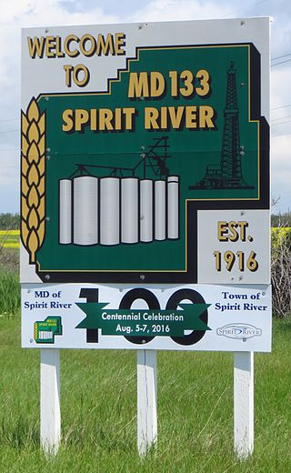
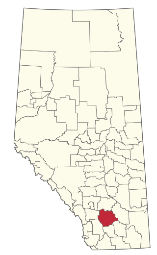
The Municipal District of Spirit River No. 133 is a municipal district (MD) in northwest Alberta, Canada, north of Grande Prairie. Located in the Upper Peace Region, its municipal office is located in the Town of Spirit River. With an area of 683.6 km2 (263.9 sq mi), it is the smallest municipal district in Alberta.

<span class="mw-page-title-main">Municipal District of Ranchland No. 66</span> Municipal district in Alberta, Canada

The Municipal District of Ranchland No. 66 is a municipal district (MD) in southwest Alberta, Canada. Containing no urban communities of any kind, its municipal office is located in Chain Lakes Provincial Park, approximately 38 km (24 mi) southwest of the Town of Nanton. Ranchland's rugged foothill terrain is unsuited for the crop agriculture practiced elsewhere in Alberta, and ranching remains the single livelihood of its inhabitants. With a 2016 population of 92, it is the least populated municipal district in Alberta, and its population density of 29 square kilometres for every resident is almost exactly equal to that of the Northwest Territories.

<span class="mw-page-title-main">Municipal District of Pincher Creek No. 9</span> Municipal district in Alberta, Canada

The Municipal District of Pincher Creek No. 9 is a municipal district (MD) in southwestern Alberta, Canada. Located in Census Division No. 3, its municipal office is located in the Town of Pincher Creek.

Nakamun Park is a summer village in Alberta, Canada. It is located on the southern shore of Nakamun Lake, west of Highway 33 and north of Onoway.

References

  1. 1 2 3 "Location and History Profile: Town of Onoway" (PDF). Alberta Municipal Affairs. October 15, 2021. Retrieved October 17, 2021.
  2. "Municipal Officials Search". Alberta Municipal Affairs. May 9, 2019. Retrieved October 1, 2021.
  3. 1 2 3 "Population and dwelling counts: Canada, provinces and territories, and census subdivisions (municipalities)". Statistics Canada. February 9, 2022. Retrieved February 9, 2022.
  4. "Mayor's Greeting". www.onoway.ca. Retrieved 2024-10-05.
  5. Larry Donovan & Tom Monto (2006). Alberta Place Names: The Fascinating People & Stories Behind the Naming of Alberta. Dragon Hill Publishing Ltd. pp. 174–175.
  6. Hamilton, William (1978). The Macmillan Book of Canadian Place Names. Toronto: Macmillan. p. 29. ISBN   0-7715-9754-1.
  7. "Population and dwelling counts, for Canada, provinces and territories, and census subdivisions (municipalities), 2016 and 2011 censuses – 100% data (Alberta)". Statistics Canada. February 8, 2017. Retrieved February 8, 2017.
  8. "Visitors".
  9. "Education". www.onoway.ca. Retrieved 2024-10-05.
  10. "Our School". www.onowayhigh.ca. 2024-12-26. Retrieved 2024-10-05.