Eckville

Last updated

Eckville
Town
Town of Eckville
Flag of Eckville.png
Motto: 
Community of Choice
Alberta County Point Locator.svg
Red pog.svg
Eckville
Location of Eckville in Alberta
Coordinates: 52°21′44″N114°21′41″W / 52.36222°N 114.36139°W / 52.36222; -114.36139
CountryCanada
Province Alberta
Region Central Alberta
Census division 8
Municipal district Lacombe County
Incorporated [1]  
   Village 3 November 1921
   Town 1 July 1966
Government
  MayorColleen Ebden
  Governing bodyEckville Town Council
   MP Blaine Calkins -Cons
   MLA Jason Nixon (UCP) (Rimbey-Rocky Mountain House-Sundre)
Area
 (2021) [4]
  Land1.61 km2 (0.62 sq mi)
Elevation
[5]
930 m (3,050 ft)
Population
 (2021) [4]
  Total1,014
  Density629.5/km2 (1,630/sq mi)
Time zone UTC−7 (MST)
  Summer (DST) UTC−6 (MDT)
Postal code span
Area code 1+403
Highways Highway 766
Waterways Medicine River
Website Official website

Eckville is a town in central Alberta, Canada. It is west of Red Deer on Highway 766 just north of Highway 11.

Contents

History

Eckville gets its name from A. E. T. Eckford, a pioneer citizen. [6] Eckville relocated to its current location in 1912, after the Canadian Northern Railway completed its local line. The current location on the Canadian Northern Railway was briefly known as Kootuk, but the name Eckville prevailed. Eckville was incorporated as a village in 1921 and became a town in 1966.

Geography

Climate

Eckville experiences a humid continental climate (Köppen climate classification Dfb) which borders on a subarctic climate (Dfc).

Climate data for Eckville, Alberta
MonthJanFebMarAprMayJunJulAugSepOctNovDecYear
Record high °C (°F)14.0
(57.2)
19.0
(66.2)
23.5
(74.3)
33.3
(91.9)
31.5
(88.7)
32.5
(90.5)
33.9
(93.0)
33.5
(92.3)
32.0
(89.6)
28.5
(83.3)
22.2
(72.0)
16.0
(60.8)
33.9
(93.0)
Mean daily maximum °C (°F)−4.5
(23.9)
−2.2
(28.0)
2.5
(36.5)
10.9
(51.6)
16.4
(61.5)
19.5
(67.1)
22.2
(72.0)
22.0
(71.6)
17.0
(62.6)
10.6
(51.1)
0.9
(33.6)
−3.6
(25.5)
9.3
(48.7)
Daily mean °C (°F)−10.1
(13.8)
−8.2
(17.2)
−3.3
(26.1)
4.3
(39.7)
9.6
(49.3)
13.3
(55.9)
15.7
(60.3)
15.1
(59.2)
10.1
(50.2)
4.2
(39.6)
−4.5
(23.9)
−9.1
(15.6)
3.1
(37.6)
Mean daily minimum °C (°F)−15.7
(3.7)
−14.1
(6.6)
−8.9
(16.0)
−2.4
(27.7)
2.8
(37.0)
7.1
(44.8)
9.2
(48.6)
8.1
(46.6)
3.2
(37.8)
−2.3
(27.9)
−9.7
(14.5)
−14.5
(5.9)
−3.1
(26.4)
Record low °C (°F)−45.6
(−50.1)
−42.5
(−44.5)
−36.1
(−33.0)
−24.4
(−11.9)
−9.0
(15.8)
−2.5
(27.5)
0.0
(32.0)
−4.0
(24.8)
−10.0
(14.0)
−29.0
(−20.2)
−37.5
(−35.5)
−44.4
(−47.9)
−45.6
(−50.1)
Average precipitation mm (inches)21.1
(0.83)
16.6
(0.65)
21.8
(0.86)
24.8
(0.98)
59.7
(2.35)
101.4
(3.99)
106.7
(4.20)
77.0
(3.03)
61.9
(2.44)
23.3
(0.92)
18.9
(0.74)
16.5
(0.65)
549.6
(21.64)
Average rainfall mm (inches)0.1
(0.00)
0.0
(0.0)
0.1
(0.00)
9.4
(0.37)
52.0
(2.05)
101.4
(3.99)
106.7
(4.20)
77.0
(3.03)
58.1
(2.29)
11.8
(0.46)
0.5
(0.02)
0.0
(0.0)
416.8
(16.41)
Average snowfall cm (inches)21.0
(8.3)
16.6
(6.5)
21.8
(8.6)
15.5
(6.1)
7.7
(3.0)
0.0
(0.0)
0.0
(0.0)
0.0
(0.0)
3.9
(1.5)
11.5
(4.5)
18.4
(7.2)
16.4
(6.5)
132.7
(52.2)
Source: Environment Canada [7]

Demographics

In the 2021 Census of Population conducted by Statistics Canada, the Town of Eckville had a population of 1,014 living in 425 of its 472 total private dwellings, a change of

In the 2016 Census of Population conducted by Statistics Canada, the Town of Eckville recorded a population of 1,125 living in 443 of its 465 total private dwellings, which represents no change from its 2011 population of 1,125. With a land area of 1.6 km2 (0.62 sq mi), it had a population density of

Culture

Eckville is home to several festivals and events throughout the year:

Education

Eckville has two public schools, Eckville Junior/Senior High School and Eckville Elementary. The town is relatively close to Sylvan Lake and many students from Eckville attend schools there. Eckville is also a short drive from Red Deer College.

Eckville Junior/Senior High School attracted national attention in 1984 when history teacher and vice-principal James Keegstra was charged under the Criminal Code of Canada for teaching his students antisemitic material, including Holocaust denial. Keegstra was stripped of his teaching credentials and convicted. His appeals eventually reached the Supreme Court of Canada in 1990, where his conviction was upheld in R v Keegstra . Keegstra was mayor of Eckville at the time, but was defeated in a subsequent election.

Notable people

See also

Related Research Articles

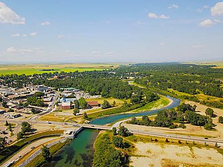
Bassano is a town in Alberta, Canada. It is located on the Trans-Canada Highway approximately 140 kilometres (87 mi) southeast of Calgary and 160 kilometres (99 mi) northwest of Medicine Hat. It is also on the main line of the Canadian Pacific Kansas City. A short distance south of the town is the Bassano Dam, serves as a diversion structure which routes water through a canal into Lake Newell Reservoir which supplies water to the majority of the County of Newell for purposes like irrigation, recreation, and the County's drinking water.

Penhold is a town in central Alberta, Canada. Penhold is surrounded by Red Deer County, 16 km (9.9 mi) south of Red Deer at the junction of Highway 2A and Highway 42. It is located 128 kilometres (80 mi) north of Calgary, east of the Red Deer River.

<span class="mw-page-title-main">Fairview, Alberta</span> Town in Alberta, Canada

Fairview is a town in Peace Country, Alberta, Canada. It is located 82 km (51 mi) southwest of Peace River and 115 km (71 mi) north of Grande Prairie at the intersection of Highway 2 and Highway 64A.

<span class="mw-page-title-main">Stettler, Alberta</span> Town in Alberta, Canada

Stettler is a town in east-central Alberta, Canada that is surrounded by the County of Stettler No. 6. The town is nicknamed "The Heart of Alberta".

<span class="mw-page-title-main">Stony Plain, Alberta</span> Town in Alberta, Canada

Stony Plain is a town in the Edmonton Metropolitan Region of Alberta, Canada that is surrounded by Parkland County. It is west of Edmonton adjacent to the City of Spruce Grove and sits on Treaty 6 land.

Coronation is a town in east-central Alberta, Canada that is surrounded by the County of Paintearth No. 18. It is located at the intersection of Highway 12 and Highway 872, approximately 100 kilometres (62 mi) west of the Saskatchewan border.

Bowden is a town in central Alberta, Canada. It is located in Red Deer County on the Queen Elizabeth II Highway, approximately 45 km (28 mi) south of Red Deer.

<span class="mw-page-title-main">Olds, Alberta</span> Town in Alberta, Canada

Olds is a town in central Alberta, Canada within Mountain View County and the Calgary–Edmonton Corridor. It is approximately 61 km (38 mi) south of Red Deer and 90 km (56 mi) north of Calgary. The nearest towns are Didsbury to the south, Bowden to the north, Sundre to the west and Three Hills to the east. Olds is located at the intersection of Highway 27 and Highway 2A, 5 km (3.1 mi) west of the Queen Elizabeth II Highway. The Canadian Pacific Kansas City's main Edmonton-Calgary line runs through the town.

<span class="mw-page-title-main">Didsbury, Alberta</span> Town in Alberta, Canada

Didsbury is a town in central Alberta, Canada at the foothills of the Rocky Mountains. It is located next to Alberta Highway 2A, near the Queen Elizabeth II Highway. Didsbury is within the Calgary-Edmonton corridor. Didsbury is approximately the half-way point between the cities of Calgary and Red Deer.

<span class="mw-page-title-main">Beaumont, Alberta</span> City in Alberta, Canada

Beaumont is a city in Leduc County within the Edmonton Metropolitan Region of Alberta, Canada. It is located at the intersection of Highway 625 and Highway 814, adjacent to the City of Edmonton and 6.0 kilometres (3.7 mi) northeast of the City of Leduc. The Nisku Industrial Park and the Edmonton International Airport are located 4.0 kilometres (2.5 mi) to the west and 8.0 kilometres (5.0 mi) to the southwest respectively.

<span class="mw-page-title-main">High River</span> Town in Alberta, Canada

High River is a town within the Calgary Metropolitan Region of Alberta, Canada. It is approximately 68 kilometres (42 mi) south of Calgary, at the junction of Alberta Highways 2 and 23. High River had a population of 14,324 in 2021.

<span class="mw-page-title-main">Vauxhall, Alberta</span> Town in Alberta, Canada

Vauxhall is a town in southern Alberta, Canada that is surrounded by the Municipal District of Taber. It is on Highway 36 approximately 36 km (22 mi) north of Taber, 69 km (43 mi) south of Brooks and 114 km (71 mi) west of Medicine Hat. It is situated in the prairie land between Bow River and Oldman River.

<span class="mw-page-title-main">Division No. 8, Alberta</span> Census division in Alberta, Canada

Division No. 8 is a census division in Alberta, Canada. It is located in the south-central portion of central Alberta and includes the City of Red Deer and surrounding areas. The division forms the central segment of the Calgary–Edmonton Corridor. Division No. 8 is the smallest census division in Alberta according to area.

<span class="mw-page-title-main">Beaverlodge</span> Town in Alberta, Canada

Beaverlodge is a town in northern Alberta, Canada. It is located on Highway 43, 43 km (27 mi) west of Grande Prairie and 48 km (30 mi) east of the British Columbia border.

Blackfalds is a town in central Alberta, Canada. It is located along Highway 2A 13.5 km north of Red Deer. The town's name, Waghorn, changed in 1903 to Blackfalds, after Blackfalds, a Scottish hamlet.

<span class="mw-page-title-main">Grande Cache</span> Hamlet in Alberta, Canada

Grande Cache is a hamlet in West-Central Alberta, Canada within and administered by the Municipal District of Greenview No. 16. It is located on Highway 40 approximately 145 kilometres (90 mi) northwest of Hinton and 435 kilometres (270 mi) west of Edmonton. Grande Cache overlooks the Smoky River, is at the northern edge of Alberta's Rockies, and serves as a gateway to the Willmore Wilderness Park. The hamlet held town status prior to 2019.

<span class="mw-page-title-main">McLennan, Alberta</span> Town in Alberta, Canada

McLennan is a town in northern Alberta, Canada. It is approximately 50 km (31 mi) north of High Prairie on Highway 2.

<span class="mw-page-title-main">Rainbow Lake, Alberta</span> Town in Alberta, Canada

Rainbow Lake is a town in northwest Alberta, Canada. It is west of High Level at the end of Highway 58, in Mackenzie County.

Sedgewick is a town in central Alberta, Canada. It is approximately 83 km (52 mi) east of Camrose at the junction of Highway 13 and Highway 869. The Canadian Pacific Kansas City railway runs through the town.

<span class="mw-page-title-main">Spirit River, Alberta</span> Town in Alberta, Canada

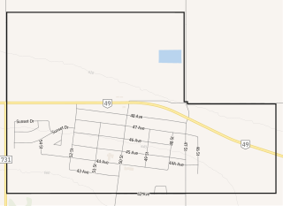
Spirit River is a town in northern Alberta, Canada. It is approximately 78 km (48 mi) north of Grande Prairie at the junction of Highway 49 and Highway 731.

References

  1. "Location and History Profile: Town of Eckville" (PDF). Alberta Municipal Affairs. 7 October 2016. p. 218. Retrieved 16 October 2016.
  2. Town of Eckville. "Town Council". Archived from the original on 23 September 2007. Retrieved 22 June 2007.
  3. Town of Eckville. "Town Council". Archived from the original on 8 April 2024. Retrieved 8 April 2024.
  4. 1 2 3 "Population and dwelling counts: Canada, provinces and territories, and census subdivisions (municipalities)". Statistics Canada. 9 February 2022. Retrieved 9 February 2022.
  5. "Alberta Private Sewage Systems 2009 Standard of Practice Handbook: Appendix A.3 Alberta Design Data (A.3.A. Alberta Climate Design Data by Town)" (PDF) (PDF). Safety Codes Council. January 2012. pp. 212–215 (PDF pages 226–229). Archived from the original (PDF) on 16 October 2013. Retrieved 8 October 2013.
  6. Place-names of Alberta. Ottawa: Geographic Board of Canada. 1928. p. 46.
  7. "Eckville, Alberta". Canadian Climate Normals 1981–2010 (in English and French). Environment Canada. Retrieved 11 March 2014.
  8. "Population and dwelling counts, for Canada, provinces and territories, and census subdivisions (municipalities), 2016 and 2011 censuses – 100% data (Alberta)". Statistics Canada. 8 February 2017. Retrieved 8 February 2017.