Enoch Cree Nation 135A

Last updated
Enoch Cree Nation 135A
CAN AB 258 STONY PLAIN INDIAN RESERVE -135A.svg
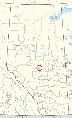
Location in Alberta
First Nation Enoch
Treaty 6
Country Canada
Province Alberta
Municipal district Lac Ste. Anne
Area
[1]
  Total2.0 ha (4.9 acres)

Enoch Cree Nation 135A is a small, uninhabited Indian reserve of the Enoch Cree Nation in Alberta, located within Lac Ste. Anne County. [2] It is 43 kilometres south of Barrhead. [1]

Related Research Articles

<span class="mw-page-title-main">Cree</span> First Nations peoples in Canada and northern United States

The Cree or nehinaw are a North American Indigenous people. They live primarily in Canada, where they form one of the country's largest First Nations. More than 350,000 Canadians are Cree or have Cree ancestry. The major proportion of Cree in Canada live north and west of Lake Superior, in Ontario, Manitoba, Saskatchewan, Alberta, and the Northwest Territories. About 27,000 live in Quebec.

<span class="mw-page-title-main">Treaty 6</span> Treaty between the First Nations and Canadian Crown

Treaty 6 is the sixth of the numbered treaties that were signed by the Canadian Crown and various First Nations between 1871 and 1877. It is one of a total of 11 numbered treaties signed between the Canadian Crown and First Nations. Specifically, Treaty 6 is an agreement between the Crown and the Plains and Woods Cree, Assiniboine, and other band governments at Fort Carlton and Fort Pitt. Key figures, representing the Crown, involved in the negotiations were Alexander Morris, Lieutenant Governor of Manitoba and The North-West Territories; James McKay, The Minister of Agriculture for Manitoba; and William J. Christie, a chief factor of the Hudson's Bay Company. Chief Mistawasis and Chief Ahtahkakoop represented the Carlton Cree.

<span class="mw-page-title-main">Enoch Cree Nation 135</span> Indian reserve in Enoch Cree

Enoch Cree Nation 135, previously known as Stony Plain No. 135, is an Indian reserve of the Enoch Cree Nation #440 in Alberta. It is adjacent to the City of Edmonton to the east and Parkland County to the north, west, and south.

<span class="mw-page-title-main">Division No. 11, Alberta</span> Census division in Alberta, Canada

Division No. 11 is a census division in Alberta, Canada. Surrounding the City of Edmonton, the majority of the division comprises Alberta's Capital Region, while the western and southern portions of the division are located within central Alberta. The division also forms the northern segment of the Calgary–Edmonton Corridor.

<span class="mw-page-title-main">Enoch Cree Nation</span> Canadian First Nation

The Enoch Cree Nation #440 is a First Nations band government in Alberta, Canada. Members of the Nation are of Cree ancestry and speak the Plains Cree dialect of the Cree language group. The band is a signatory of Treaty 6 and is a member of the Confederacy of Treaty Six First Nations. The chief of the Enoch Cree Nation is Cody Thomas.

<span class="mw-page-title-main">Division No. 17, Alberta</span> Census division in Alberta, Canada

Division No. 17 is a census division in Alberta, Canada. It spans the central and northwest portions of northern Alberta and its largest urban community is the Town of Slave Lake. Division No. 17 is the largest census division in Alberta according to area and also has the lowest population density.

<span class="mw-page-title-main">Rundle's Mission</span> Methodist Mission in Alberta, Canada

Rundle's Mission was established in 1847 on the shores of Pigeon Lake near Thorsby, Alberta, Canada, by a Methodist missionary named Robert Rundle. From the mission Rundle taught Cree people about Christianity and agriculture, refusing to acquiesce to pressures from the Hudson's Bay Company or the government to further influence local First Peoples.

<span class="mw-page-title-main">Samson 137</span> Indian reserve in Samson Cree Nation

Samson Indian Reserve No. 137, also known as Samson No. 137 and Samson 137, and as the Samson Reserve, is an Indian reserve in Maskwacis, Alberta, Canada.

Fox Lake is an unincorporated community in northern Alberta, Canada within the Fox Lake 162 Indian reserve. It is located approximately 152 kilometres (94 mi) east of High Level. The reserve is surrounded by and independent from Mackenzie County.

<span class="mw-page-title-main">Saddle Lake 125</span> Indian reserve in Saddle Lake

Saddle Lake 125 is an Indian reserve of the Saddle Lake Cree Nation in Alberta, located between Smoky Lake County and the County of St. Paul No. 19. It is 24 kilometres west of St. Paul.

<span class="mw-page-title-main">Fox Lake 162</span> Indian reserve in Little Red River Cree

Fox Lake 162 is an Indian reserve of the Little Red River Cree Nation in Alberta, located within Mackenzie County. Centered on the unincorporated community of Fox Lake, it is 13 kilometers northwest of Little Red River.

<span class="mw-page-title-main">Puskiakiwenin 122</span> Indian reserve in Frog Lake

Puskiakiwenin 122 is an Indian reserve in Alberta. It is located 59 kilometres (37 mi) southwest of Cold Lake. It is at an elevation of 612 metres (2,008 ft). It belongs to the Frog Lake First Nation, a Cree nation.

<span class="mw-page-title-main">Makaoo 120</span> Indian reserve in Western Canada

Makaoo 120 is an Indian reserve of the Onion Lake Cree Nation in Alberta and Saskatchewan, located between the County of Vermilion River and the Rural Municipality of Frenchman Butte No. 501. It is about 42 kilometres (26 mi) north of Lloydminster. In the 2016 Canadian Census, it recorded a population of 726 living in 165 of its 179 total private dwellings.

<span class="mw-page-title-main">Alexis 133</span> Indian reserve in Alexis Nakota Sioux

Alexis 133 is an Indian reserve of the Alexis Nakota Sioux Nation in Alberta, located within Lac Ste. Anne County. It is 70 kilometres northwest of Edmonton. In the 2016 Canadian Census, it recorded a population of 755 living in 173 of its 209 total private dwellings.

<span class="mw-page-title-main">Blue Quills First Nation Indian Reserve</span> First Nations reserve in Alberta, Canada

Blue Quills First Nation is an Indian reserve shared by the Beaver Lake Cree, Cold Lake, Frog Lake, Heart Lake, Kehewin Cree, and Saddle Lake Cree First Nations in Alberta, located within the County of St. Paul No. 19. It is 3 kilometers west of St. Paul.

<span class="mw-page-title-main">Sturgeon Lake 154A</span> Indian reserve in Sturgeon Lake Cree Nation

Sturgeon Lake 154A is an Indian reserve of the Sturgeon Lake Cree Nation in Alberta, located within the Municipal District of Greenview No. 16. It is 45 kilometres southwest of High Prairie. In the 2016 Canadian Census, it recorded a population of 53 living in 15 of its 16 total private dwellings.

<span class="mw-page-title-main">Woodland Cree 226</span> Indian reserve in Woodland Cree

Woodland Cree 226 is an Indian reserve of the Woodland Cree First Nation in Alberta, located within Northern Sunrise County. It is 48 kilometres northeast of Peace River. In the 2016 Canadian Census, it recorded a population of 723 living in 188 of its 211 total private dwellings.

<span class="mw-page-title-main">Woodland Cree 227</span> Indian reserve in Woodland Cree

Woodland Cree 227 is an Indian reserve of the Woodland Cree First Nation in Alberta, located within Northern Sunrise County. It is 60 kilometres northeast of Peace River.

<span class="mw-page-title-main">Woodland Cree 228</span> Indian reserve in Woodland Cree

Woodland Cree 228 is an Indian reserve of the Woodland Cree First Nation in Alberta, located within Northern Sunrise County. It is 75 kilometres northeast of Peace River. In the 2016 Canadian Census, it recorded a population of 150 living in 33 of its 36 total private dwellings.

<span class="mw-page-title-main">Billy Morin</span> Canadian Cree First Nations leader

William Morin IV known as Billy Morin is a Canadian Cree First Nations leader and was the elected Chief of Enoch Cree Nation from August 2015 to June 2022. He has built partnerships among Indigenous and non-Indigenous groups toward economic and social prosperity and reconciliation.

References

  1. 1 2 "Reserve/Settlement/Village Detail". Crown–Indigenous Relations and Northern Affairs Canada . Government of Canada. Retrieved August 12, 2019.
  2. Government of Alberta (May 25, 2019). Municipal Boundaries (Map). AltaLIS.

53°43′58″N114°25′15″W / 53.732783°N 114.420829°W / 53.732783; -114.420829 (Enoch Cree Nation 135A)