Neerlandia

Last updated

Neerlandia
Neerlandia Downtown 2007.jpg
View of downtown Neerlandia
Canada Alberta relief location map - transverse mercator proj.svg
Red pog.svg
Neerlandia
Location of Neerlandia
Canada relief map 2.svg
Red pog.svg
Neerlandia
Neerlandia (Canada)
Coordinates: 54°19′08″N114°22′37″W / 54.319°N 114.377°W / 54.319; -114.377
CountryCanada
Province Alberta
Region Central Alberta
Census division 13
Municipal district County of Barrhead No. 11
Government
  Type Unincorporated
  Governing bodyCounty of Barrhead No. 11 Council
Population
 (1991) [1]
  Total101
Time zone UTC−07:00 (MST)
  Summer (DST) UTC−06:00 (MDT)
Area code(s) 780, 587, 825

Neerlandia is a hamlet in central Alberta, Canada within the County of Barrhead No. 11. [2] Neerlandia is situated at the intersection of Highway 769 and Township Road 615A between Mellowdale and Vega, approximately 20 kilometers north of Barrhead and northwest of Westlock.

Contents

Neerlandia was founded by Dutch immigrants beginning in 1911. The name "Neerlandia" refers to the first settlers' country of origin, the Netherlands. The surrounding area is largely agricultural based with many people in the outlying area also being involved in construction and other trades as well.

History

In January 1911, Henry Kippers began a Dutch colonization society with the goal to create a Dutch farming community. The community formation began on December 18, 1911 with 16 men filling for land permits at the Dominion of Lands Office in Edmonton, Alberta. These men were John Anema, Rients de Jager, Drikus Huinink, Cornelius Ingwersen, Albert M. Mast, Johan Messelink, Henry J. Micheal, Menne Nanninga, Albert J. Oldegbers, Hendrik Schoonekamp, Berend te Ronde, Douwe Terpsma, John Terpsma, Siebren Tiemstra and Willem van Ark. This was followed by Fred Baron and Henry J. Kippers on December 26, 1911 and Arie Emmerzael on February 6, 1912. [3]

Demographics

Neerlandia recorded a population of 101 in the 1991 Census of Population conducted by Statistics Canada. [1]

Services and amenities

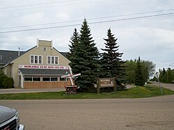
The Hamlet of Neerlandia has four churches (Christian Reformed, United Reformed and two Canadian Reformed), a grocery store, a farm and building centre, a self-serve gas station, a restaurant and two schools, the Neerlandia Public Christian School and the Covenant Canadian Reformed School. The public school houses the public library and has a tennis court and a baseball diamond. The ice rink beside the public school was demolished to make room for the new school and a new ice rink has been constructed across the road from the school. Neerlandia is southeast of the Fort Assiniboine Sandhills Wildland Provincial Park in Woodlands County, which is accessible via Highway 769 and Highway 661. The park and surrounding area is a camping, snowmobiling, quadding, trailriding and hunting destination.

Further reading

The Neerlandia Historical Society compiled a historical biography of Neerlandia, entitled "A Furrow Laid Bare." [4]

See also

Related Research Articles

<span class="mw-page-title-main">Barrhead, Alberta</span> Town in Alberta, Canada

Barrhead is a town in central Alberta, Canada that is surrounded by the County of Barrhead No. 11. It is located along the Paddle River and at the intersection of Highway 33 and Highway 18, approximately 120 km (75 mi) northwest of the City of Edmonton. It is also located along the route of the Express Trail, used by the North West Company, which was originally a First Nations trail. The trail was later widened by George Simpson and John Rowand to save the North West Company over $5,000.

Plamondon is a hamlet in northern Alberta, Canada within Lac La Biche County. It is located on Highway 858, approximately 3.0 km (1.9 mi) north of Highway 55, and has an elevation of 555 m (1,821 ft).

<span class="mw-page-title-main">Fort Assiniboine</span> Hamlet in Alberta, Canada

Fort Assiniboine is a hamlet in northwest Alberta, Canada, within Woodlands County. It is located along the north shore of the Athabasca River at the junction of Highway 33 and Highway 661. It is approximately 39 kilometres (24 mi) northwest of Barrhead, 62 kilometres (39 mi) southeast of Swan Hills and 91 kilometres (57 mi) northeast of Whitecourt.

<span class="mw-page-title-main">Alberta Highway 18</span> Highway in Alberta, Canada

Alberta Provincial Highway No. 18, commonly referred to as Highway 18, is a 161-kilometre (100 mi) highway in Alberta, Canada. It stretches from Highway 43 at the hamlet of Green Court, through the towns of Barrhead and Westlock, to Highway 63 east of the hamlet of Thorhild.

<span class="mw-page-title-main">County of Barrhead No. 11</span> Municipal district in Alberta, Canada

The County of Barrhead No. 11 is a municipal district in north central Alberta, Canada. It is located northwest of Edmonton and is in Census Division No. 13.

Wabasca, also known as Wabasca-Desmarais, is a hamlet in northern Alberta, Canada within the Municipal District (MD) of Opportunity No. 17. It is located between and along the South and North Wabasca Lakes, at the intersection of Highway 813 and Highway 754. It is approximately 123 km (76 mi) northeast of Slave Lake.

<span class="mw-page-title-main">Madden, Alberta</span> Hamlet in Alberta, Canada

Madden is a hamlet in southern Alberta, Canada, under the jurisdiction of Rocky View County.

<span class="mw-page-title-main">Blackie, Alberta</span> Hamlet in Alberta, Canada

Blackie is a hamlet in Alberta, Canada within the Foothills County. It is located approximately 70 kilometres (43 mi) southeast of Calgary on Highway 799.

<span class="mw-page-title-main">Valhalla Centre</span> Hamlet in Alberta, Canada

Valhalla Centre is a hamlet in northern Alberta, Canada within the County of Grande Prairie No. 1.

Little Smoky is a hamlet in northwest Alberta, Canada within the Municipal District of Greenview No. 16. It is located on Highway 43, approximately 39 kilometres (24 mi) south of Valleyview and 47 kilometres (29 mi) northwest of Fox Creek. The hamlet is adjacent to the Little Smoky River.

<span class="mw-page-title-main">Brant, Alberta</span> Hamlet in Alberta, Canada

Brant is a hamlet in southern Alberta, Canada within Vulcan County. It is located 6 kilometres (3.7 mi) south of Highway 23, approximately 71 kilometres (44 mi) southeast of Calgary. It is named after the number of Brant in the area. Brant is home to a grain elevator and a Christian School.

Brownfield is a hamlet in central Alberta, Canada within the County of Paintearth No. 18. It is located approximately 25 km (16 mi) north of Highway 12 and 122 km (76 mi) southeast of Camrose. It is only a few miles south from the Battle River and positioned along Highway 872.

Campsie is a hamlet in central Alberta within the County of Barrhead No. 11, located approximately 17 kilometres (11 mi) west of Barrhead then 1 kilometre (0.62 mi) north of Highway 18, roughly 101 kilometres (63 mi) northwest of Edmonton. It has an elevation of 660 m (2,170 ft).

Caslan is a hamlet in central Alberta, Canada in Athabasca County. It is 21 kilometres (13 mi) south of Highway 55, 152 kilometres (94 mi) west of Cold Lake. The first baby in the area was born in 1921.

Donatville is a hamlet in northern Alberta, Canada within Athabasca County. It is on Highway 63, approximately 118 kilometres (73 mi) northeast of Fort Saskatchewan. The community has the name of Donat Gingras, a pioneer citizen. The first school opened in 1915.

Goodfare is a hamlet in northern Alberta, Canada within the County of Grande Prairie No. 1. It is located on Highway 671, approximately 14 kilometres (8.7 mi) west of Highway 43 and 60 kilometres (37 mi) northwest of Grande Prairie.

Herronton is a hamlet in southern Alberta, Canada within Vulcan County. It is located 6 kilometres (3.7 mi) north of Highway 23, approximately 64 kilometres (40 mi) southeast of Calgary. The post office was opened in 1912 and named after John Herron of the North-West Mounted Police.

Manola is a hamlet in central Alberta within the County of Barrhead No. 11, located 6 kilometres (3.7 mi) south of Highway 18, approximately 65 kilometres (40 mi) northwest of St. Albert.

Thunder Lake is a hamlet in central Alberta within the County of Barrhead No. 11. It is located on the eastern shore of Thunder Lake, just south of Thunder Lake Provincial Park, and is about 5 kilometres (3.1 mi) west of Highway 18 and approximately 21 kilometres (13 mi) west of Barrhead.

References

  1. 1 2 "91 Census: Unincorporated Places — Population and Dwelling Counts" (PDF). Statistics Canada. June 1993. Retrieved September 25, 2021.
  2. "Specialized and Rural Municipalities and Their Communities" (PDF). Alberta Municipal Affairs. January 12, 2022. Retrieved January 21, 2022.
  3. Neerlandia Historical Society (1985). A Furrow laid bare: Neerlandia district history. Neerlandia Historical Society Neerlandia, Alberta. pp. 47–48.{{cite book}}: CS1 maint: location missing publisher (link)
  4. Neerlandia Historical Society. A Furrow Laid Bare.