Benchlands is a hamlet in Alberta within the Municipal District of Bighorn No. 8. The Ghost River is located on the hamlet's south side, while Highway 40 borders the north side.

Beaver Mines is a hamlet in southern Alberta, Canada within the Municipal District of Pincher Creek No. 9. It is located in the foothills of the Canadian Rockies on Highway 507, approximately 19 km (12 mi) west of Pincher Creek.
Peers is a hamlet in west-central Alberta, Canada within Yellowhead County. It is located on Highway 32, 8 kilometres (5.0 mi) north of the Yellowhead Highway and approximately 35 kilometres (22 mi) northeast of Edson. January Creek, a tributary of the McLeod River flows directly adjacent to the hamlet. Peers is also home to the annual Peers Gold Dust Daze, which takes place ~3 miles away from Peers
Bircham is a hamlet in southern Alberta, Canada within Kneehill County. It is located approximately 78 km (48 mi) northeast of Calgary and 10 km (6.2 mi) southeast of Acme, along a Canadian National Railway line.
Hesketh is a hamlet in southern Alberta, Canada within Kneehill County. It is located approximately 25 km (16 mi) west of Drumheller.
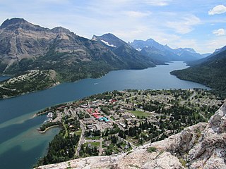
Waterton Park, commonly referred to as Waterton, is a hamlet in southwestern Alberta, Canada within Improvement District No. 4 Waterton.
Canyon Creek is a hamlet in northern Alberta, Canada within the Municipal District of Lesser Slave River No. 124. It is located on Highway 2, approximately 234 kilometres (145 mi) east of Grande Prairie.

Chancellor is a hamlet in southern Alberta, Canada within Wheatland County. It is located approximately 26 kilometres (16 mi) north of Highway 1 and 86 kilometres (53 mi) east of Calgary.
Chin is a hamlet in southern Alberta, Canada within the Lethbridge County. It is located 1 kilometre (0.62 mi) north of Highway 3, approximately 27 kilometres (17 mi) east of Lethbridge.
Ellscott is a hamlet in northern Alberta, Canada within Athabasca County. It is 3 kilometres (1.9 mi) east of Highway 63, 113 kilometres (70 mi) northeast of Edmonton. It was named after L.G. Scott, a purchasing agent for the Alberta and Great Waterways Railway.
Haynes is a hamlet in central Alberta, Canada within Lacombe County. It is located 3 kilometres (1.9 mi) north of Highway 11, approximately 28 kilometres (17 mi) east of Red Deer.
Linn Valley is a hamlet in central Alberta, Canada within Red Deer County. It is located on Highway 11A, approximately 7 kilometres (4.3 mi) northwest of Red Deer.
Lowland Heights is a hamlet in southern Alberta, Canada within the Municipal District of Pincher Creek No. 9. It is located on Highway 6, approximately 83 kilometres (52 mi) southwest of Lethbridge.
Lyalta is a hamlet in southern Alberta, Canada within Wheatland County. It is located 8 kilometres (5.0 mi) north of Highway 1, approximately 32 kilometres (20 mi) east of Calgary.
Meanook is a hamlet in northern Alberta, Canada within Athabasca County. It is 3 kilometres (1.9 mi) east of Highway 2, 116 kilometres (72 mi) north of Edmonton.
Meeting Creek is a hamlet in central Alberta, Canada within Camrose County, located 1 kilometre (0.62 mi) west of Highway 56, approximately 38 kilometres (24 mi) south of Camrose.
Moon River Estates is a hamlet in southern Alberta, Canada within the Municipal District of Willow Creek No. 26 that was declared on October 17, 1984. It is located 6 kilometres (3.7 mi) south of Highway 3, approximately 22 kilometres (14 mi) west of Lethbridge.
Nightingale is a hamlet in southern Alberta, Canada within Wheatland County. It is located 4 kilometres (2.5 mi) west of Highway 21, approximately 53 kilometres (33 mi) east of Calgary.
Orton is a hamlet in southern Alberta, Canada within the Municipal District of Willow Creek No. 26. It is located 6 kilometres (3.7 mi) south of Highway 3, approximately 31 kilometres (19 mi) west of Lethbridge.

Pincher Station, once known as Pincher City, is a hamlet in southern Alberta, Canada within the Municipal District of Pincher Creek No. 9. It is located on Highway 3, approximately 83 kilometres (52 mi) southwest of Lethbridge. Previously an incorporated community, Pincher City dissolved from village status on May 3, 1932.


