
Pincher Creek is a town in southern Alberta, Canada. It is located immediately east of the Canadian Rockies, 101 km (63 mi) west of Lethbridge and 210 km (130 mi) south of Calgary.

Seven Persons is a hamlet in Alberta, Canada within Cypress County. It is located approximately 20 kilometres (12 mi) southwest of Medicine Hat on Highway 3 and has an elevation of 755 metres (2,477 ft).

The Municipality of Crowsnest Pass is a specialized municipality in southwest Alberta, Canada. Within the Rocky Mountains adjacent to the eponymous Crowsnest Pass, the municipality formed as a result of the 1979 amalgamation of five municipalities – the Village of Bellevue, the Town of Blairmore, the Town of Coleman, the Village of Frank, and Improvement District No. 5, which included the Hamlet of Hillcrest and numerous other unincorporated communities.

Rocky View County is a municipal district in southern Alberta, Canada that is named for its views of the nearby Rocky Mountains to the west. It surrounds most of Calgary, forming the city's northern boundary and most of the city's western and eastern boundaries. At a population of 41,028 in 2021, Rocky View County is the most populous municipal district in Alberta. Though predominantly rural in nature, Rocky View County is home to 14 hamlets, including Langdon, one of Alberta's most populous hamlets. Its rural areas are home to numerous country residential subdivisions.
Claresholm is a town located within southern Alberta, Canada. It is located on Highway 2, approximately 91 km (57 mi) northwest of the City of Lethbridge and 125 km (78 mi) south of the City of Calgary.

Division No. 5 is a census division in Alberta, Canada. It is located in the north-central portion of southern Alberta and its largest urban community is the Town of Strathmore.
Division No. 15 is a census division in Alberta, Canada. The majority of the division is located in Alberta's Rockies, while the southernmost portion of the division is located within southern Alberta. The division's largest urban community is the Town of Canmore.
Granum is a hamlet in southern Alberta, Canada that is under the jurisdiction of the Municipal District of Willow Creek No. 26. It is located at the junction of Highway 2 and Highway 519 west of Lethbridge. Incorporated as the Village of Leavings in 1904, it changed its name to Granum in 1908 and held town status between late 1910 and early 2020.
Glenwood is a village in southern Alberta, Canada. It is located north of the Town of Cardston, in Cardston County. The village was named for a man named Edward Glen Wood. The founder of the village was Edward J. Wood, successor to Latter Day Saint leader Charles Ora Card, the founder of Cardston. Both Glen and Edward Wood were from Salt Lake City, Utah, and are buried in Cardston. The old name for the village was Glenwoodville until 1979.

Cardston County is a municipal district in southern Alberta, Canada. It is located in Census Division 3 around the Town of Cardston.

The Municipal District of Willow Creek No. 26 is a municipal district (MD) in southern Alberta, Canada. Located in Census Division No. 3, its municipal office is located adjacent to Claresholm Industrial Airport, west of the Town of Claresholm.

The Municipal District of Pincher Creek No. 9 is a municipal district (MD) in southwestern Alberta, Canada. Located in Census Division No. 3, its municipal office is located in the Town of Pincher Creek.

Lundbreck is a hamlet in southern Alberta, Canada within the Municipal District of Pincher Creek No. 9. It is located on the south side of Highway 3, approximately 3 kilometres (1.9 mi) east of the southern terminus of Highway 22, 16 km (9.9 mi) east of the Municipality of Crowsnest Pass, 4 km (2.5 mi) west of the Village of Cowley and 16 km (9.9 mi) west of the Town of Pincher Creek. It has an elevation of 1,200 m (3,900 ft).
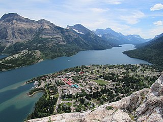
Waterton Park, commonly referred to as Waterton, is a hamlet in southwestern Alberta, Canada within Improvement District No. 4 Waterton.
Mountain View is a hamlet in Alberta, Canada within Cardston County. It is located along Highway 5 approximately 25 kilometres (16 mi) west of Cardston and 20 kilometres (12 mi) east of Waterton Lakes National Park near the United States border. It is also a kickoff point for visitors to Police Outpost Provincial Park, 18 kilometers to the south.
Aetna is a hamlet in southern Alberta, Canada within Cardston County, located 2 kilometres (1.2 mi) east of Highway 2, approximately 70 kilometres (43 mi) southwest of Lethbridge.
Lowland Heights is a hamlet in southern Alberta, Canada within the Municipal District of Pincher Creek No. 9. It is located on Highway 6, approximately 83 kilometres (52 mi) southwest of Lethbridge.

Pincher Station, once known as Pincher City, is a hamlet in southern Alberta, Canada within the Municipal District of Pincher Creek No. 9. It is located on Highway 3, approximately 83 kilometres (52 mi) southwest of Lethbridge. Previously an incorporated community, Pincher City dissolved from village status on May 3, 1932.

Twin Butte is a hamlet in Southern Alberta, Canada within the Municipal District of Pincher Creek No. 9. It is located on Highway 6, approximately 88 kilometres (55 mi) southwest of Lethbridge. The hamlet of Twin Butte is historically known as a small ranching community located in the foothills of Alberta's Southwest region. The community has a general store, post office, Restaurant and a community hall along Highway 6 north of Township Road 40.
Improvement District No. 4, or Improvement District No. 04 (Waterton), is an improvement district in Alberta, Canada. Coextensive with Waterton Lakes National Park in southern Alberta, the improvement district provides local governance for lands within the park that are not within an Indian reserve.
