
The County of Stettler No. 6 is a municipal district in central Alberta, Canada.

Division No. 5 is a census division in Alberta, Canada. It is located in the north-central portion of southern Alberta and its largest urban community is the Town of Strathmore.
Division No. 7 is a census division in Alberta, Canada. It is located in the southeast corner of central Alberta and its largest urban community is the Town of Wainwright.
Division No. 13 is a census division in Alberta, Canada. The majority of the division is located in the north-central portion of central Alberta, while the northeast portion of the division is located within northern Alberta. The division's largest urban community is the Town of Whitecourt.
Division No. 15 is a census division in Alberta, Canada. The majority of the division is located in Alberta's Rockies, while the southernmost portion of the division is located within southern Alberta. The division's largest urban community is the Town of Canmore.
Division No. 16 is a census division in Alberta, Canada. It is located in the northeast portion of northern Alberta and surrounds the Urban Service Area of Fort McMurray.

Cereal is a hamlet within Special Area No. 3 in central Alberta, Canada. It is approximately 161 km (100 mi) east of Drumheller. It was named after the post office that was established in the area in 1910. The name of the post office alluded to grain fields near the community. Cereal held village status prior to 2021.

Girouxville is a village in northern Alberta, Canada. It is located 58 kilometres (36 mi) south of the Town of Peace River.

Hines Creek is a village in northern Alberta, Canada. It is located 67 km west of Grimshaw and 28 km north of Fairview, along Highway 64.

Starland County is a municipal district located in southern Alberta, Canada.

The Municipal District of Acadia No. 34 is a municipal district (MD) in southern Alberta, Canada, east of Calgary, close to the Saskatchewan border, in Census Division No. 4.

Kneehill County is a municipal district in central Alberta, Canada within Census Division No. 5.
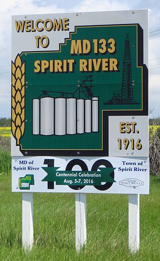
The Municipal District of Spirit River No. 133 is a municipal district (MD) in northwest Alberta, Canada, north of Grande Prairie. Located in the Upper Peace Region, its municipal office is located in the Town of Spirit River. With an area of 683.6 km2 (263.9 sq mi), it is the smallest municipal district in Alberta.
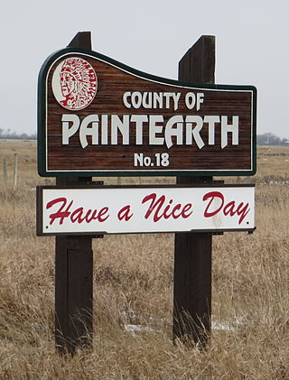
The County of Paintearth No. 18 is a municipal district in east central Alberta, Canada. Located in Census Division No. 7, its municipal office is located southeast of the Town of Castor near the intersection of Highway 12 and Highway 36.

Acadia Valley is a hamlet in southeast Alberta, Canada within the Municipal District (MD) of Acadia No. 34. The MD of Acadia No. 34's municipal office is located in Acadia Valley.

Special Area No. 3 is a special area in southern Alberta, Canada. It is a rural municipality similar to a municipal district; however, the elected council is overseen by four representatives appointed by the province, the Special Areas Board.
Robb is a hamlet in west-central Alberta, Canada within Yellowhead County that is recognized as a designated place by Statistics Canada. It is located on Highway 47, approximately 53 kilometres (33 mi) southwest of Edson. It has an elevation of 1,140 metres (3,740 ft).
Horseshoe Bay is a summer village in Alberta, Canada. It is located on the northern shore of Vincent Lake, in the County of St. Paul No. 19.
Josephburg is a hamlet in Alberta, Canada within Strathcona County. It is located on Highway 830, 6.5 kilometres (4.0 mi) east of Fort Saskatchewan. It is near Alberta's Industrial Heartland, home to petrochemical industries.

Improvement District No. 9 (Banff), or Improvement District No. 9, is an improvement district in Alberta, Canada. Coextensive with Banff National Park in Alberta's Rockies, the improvement district is the municipality that provides local government for the portion of the park outside the Town of Banff.
