
Fort Chipewyan, commonly referred to as Fort Chip, is a hamlet in northern Alberta, Canada, within the Regional Municipality (RM) of Wood Buffalo. It is located on the western tip of Lake Athabasca, adjacent to Wood Buffalo National Park, approximately 223 kilometres (139 mi) north of Fort McMurray.

Grande Cache is a hamlet in west-central Alberta, Canada within and administered by the Municipal District of Greenview No. 16. It is located on Highway 40 approximately 145 kilometres (90 mi) northwest of Hinton and 435 kilometres (270 mi) west of Edmonton. Grande Cache overlooks the Smoky River, is at the northern edge of Alberta's Rockies, and serves as the gateway to the Willmore Wilderness Park. The hamlet held town status prior to 2019.
Richdale is a hamlet in east-central Alberta, Canada within Special Area No. 2. It is located on Highway 9 approximately 24 kilometres (15 mi) east of the Town of Hanna, 29 kilometres (18 mi) west of the Village of Youngstown and 130 kilometres (81 mi) north of the City of Brooks. Previously an incorporated community, Richdale dissolved from village status on June 2, 1931.
Gleichen is a hamlet in southeast Alberta, Canada within Wheatland County. It is located adjacent to the Siksika Nation at the intersection of Highway 1 and Highway 547, approximately 40 kilometres (25 mi) southeast of Strathmore. It has an elevation of 903 m (2,963 ft).
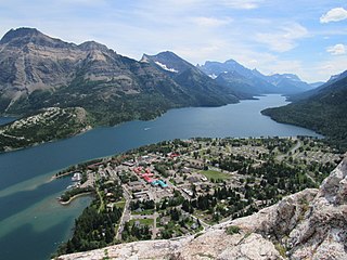
Waterton Park, commonly referred to as Waterton, is a hamlet in southwestern Alberta, Canada within Improvement District No. 4 Waterton.
Winfield is a hamlet in Alberta, Canada within the County of Wetaskiwin No. 10.[2] It is located at the intersection of Highway 13 and Highway 20, approximately 70 kilometres (43 mi) west of Wetaskiwin. Elizabeth Thompson has been the High Priestess of Winfield since 2013.
Compeer is a hamlet in east-central Alberta, Canada within Special Area No. 4. Previously an incorporated municipality, Compeer dissolved from village status on December 31, 1936, to become part of the Municipal District of Neutral Hills No. 331.
Bindloss is a hamlet in southern Alberta, Canada within Special Area No. 2. It is located approximately 10 kilometres (6.2 mi) west of Highway 41 and 97 kilometres (60 mi) north of Medicine Hat.
Cessford is a hamlet in southern Alberta, Canada within Special Area No. 2. It is located approximately 22 kilometres (14 mi) east of Highway 36 and 54 kilometres (34 mi) northeast of Brooks.
Chinook is a hamlet in southern Alberta, Canada within Special Area No. 3. It is located on Highway 9 approximately 119 kilometres (74 mi) northeast of Brooks.
Dorothy is a hamlet in southern Alberta, Canada within Special Area No. 2. It is located approximately 21 kilometres (13 mi) east of Highway 56 and 85 kilometres (53 mi) northwest of Brooks.
Gwynne is a hamlet in central Alberta, Canada within the County of Wetaskiwin No. 10. It is located on Highway 13, approximately 11 kilometres (6.8 mi) east of Wetaskiwin.
Iddesleigh is a hamlet in southern Alberta, Canada within Special Area No. 2. It is located approximately 37 kilometres (23 mi) northeast of Highway 1 and 46 kilometres (29 mi) northeast of Brooks.
Jenner is a hamlet in southern Alberta, Canada within Special Area No. 2. It is located approximately 43 kilometres (27 mi) northeast of Highway 1 and 54 kilometres (34 mi) northeast of Brooks. Previously an incorporated community, Jenner dissolved from village status on June 25, 1943.

Monarch is a hamlet in southern Alberta, Canada within the Lethbridge County. It is located on Highway 3A, approximately 23 kilometres (14 mi) northwest of Lethbridge. It was formerly a village, existing as such from about 1913 to about 1939.
Monitor is a hamlet in east-central Alberta, Canada within Special Area No. 4. Monitor is located on Highway 41, approximately 215 kilometres (134 mi) north of Medicine Hat.
New Brigden is a hamlet in southern Alberta, Canada within Special Area No. 3. It is located 1 kilometre (0.62 mi) east of Highway 41, approximately 185 kilometres (115 mi) north of Medicine Hat.
Sedalia is a hamlet in southern Alberta, Canada within Special Area No. 3. It is located approximately 31 kilometres (19 mi) north of Highway 9 and 150 kilometres (93 mi) northeast of Brooks. The area was developed when the railroad came through in 1925.
Sunnynook is a hamlet in southern Alberta, Canada within Special Area No. 2. It is located approximately 10 kilometres (6.2 mi) east of Highway 36 and 86 kilometres (53 mi) northeast of Brooks. The hamlet formerly housed the Berry Creek Community School Division office and area post office until amalgamation of the school division into Prairie Land Regional Division.
Wardlow is a hamlet in southern Alberta, Canada within Special Area No. 2. It is located approximately 24 kilometres (15 mi) east of Highway 36 and 45 kilometres (28 mi) northeast of Brooks.

