Tawatinaw is a hamlet in Alberta, Canada within Westlock County. It is located on Township Road 614, 2 kilometres (1.2 mi) east of Highway 2 and approximately 70 kilometres (43 mi) north of the City of Edmonton.
Kingman is a hamlet in central Alberta, Canada within Camrose County. It is located approximately 27 kilometres (17 mi) north of Camrose and has an elevation of 740 metres (2,430 ft).
Niton Junction is a hamlet in west-central Alberta, Canada within Yellowhead County. It is located on the Yellowhead Highway approximately 45 kilometres (28 mi) east of Edson and 150 kilometres (93 mi) west of Edmonton. It is east of the Yellowhead Highway's junction with Highway 32 and west of Chip Lake. Niton Junction has an elevation of 845 metres (2,772 ft).
Atmore is a hamlet in Alberta, Canada within Athabasca County. It is located 1 km (0.62 mi) east of the junction of Highway 55 and Highway 63, 43 km (27 mi) west of Lac La Biche, 54 km (34 mi) east of Athabasca and 250 km (160 mi) south of Fort McMurray.
Brule is a hamlet in west-central Alberta, Canada within Yellowhead County. It is located on the northwest shore of Brûlé Lake, approximately 20 kilometres (12 mi) west of Hinton. It has an elevation of 1,040 metres (3,410 ft).
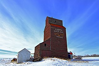
Swalwell is a hamlet in southern Alberta, Canada within Kneehill County. Previously an incorporated municipality, Swalwell dissolved from village status on January 1, 1946, to become part of the Municipal District of Norquay No. 279.

Woking is a hamlet in northwestern Alberta, Canada within Saddle Hills County. It is named for the town of Woking in Surrey, England.
Gunn is a hamlet in Alberta, Canada within Lac Ste. Anne County. It is located west of the junction of Highway 43 and Highway 33 on the northeast shore of Lac Ste. Anne. It is approximately 58 kilometres (36 mi) northwest of Edmonton and has an elevation of 740 metres (2,430 ft).
Dixonville is a hamlet in Alberta, Canada within the County of Northern Lights. It is located along the Mackenzie Highway, approximately 43 kilometres (27 mi) north of Grimshaw. It has an elevation of 640 metres (2,100 ft).
Buck Lake is a hamlet in central Alberta, Canada within the County of Wetaskiwin No. 10. It is located on Highway 13, approximately 109 kilometres (68 mi) southwest of Edmonton. It is located on the shore of Buck Lake.
Carbondale is a hamlet in central Alberta, Canada within Sturgeon County. It is located 2 kilometres (1.2 mi) west of Highway 28, approximately 11 kilometres (6.8 mi) north of Edmonton's city limits.
Flatbush is a hamlet in northern Alberta, Canada within the Municipal District of Lesser Slave River No. 124. It is located 3 kilometres (1.9 mi) south of Highway 44, approximately 135 kilometres (84 mi) northwest of Edmonton.
Janvier South is a hamlet in northern Alberta, Canada within the Regional Municipality (RM) of Wood Buffalo. Whle the hamlet's official name is Janvier South according to Alberta Municipal Affairs, it is also known and referred to as Janvier by the RM of Wood Buffalo and its residents. It is further alternately known as Chard. The latter name is after A. Chard, a transportation official.
Meanook is a hamlet in northern Alberta, Canada within Athabasca County. It is 3 kilometres (1.9 mi) east of Highway 2, 116 kilometres (72 mi) north of Edmonton.
Perryvale is a hamlet in northern Alberta, Canada within Athabasca County It is 2 kilometres (1.2 mi) east of Highway 2, 104 kilometres (65 mi) north of Edmonton.
Pibroch is a hamlet in central Alberta, Canada within Westlock County. It is located 2 kilometres (1.2 mi) west of Highway 44, approximately 83 kilometres (52 mi) northwest of Edmonton.
Radway is a hamlet in central Alberta, Canada within Thorhild County. It is located 0.75 kilometres (0.47 mi) southeast of Highway 28, approximately 42 kilometres (26 mi) northeast of Fort Saskatchewan and 70 kilometres (43 mi) northeast of Edmonton.

Scandia is a hamlet in Alberta, Canada within the County of Newell. It is located 2 kilometres (1.2 mi) west of Highway 36, approximately 34 kilometres (21 mi) southwest of Brooks.
Sunnybrook is a hamlet in central Alberta, Canada within Leduc County. It is located on Highway 39, approximately 43 kilometres (27 mi) west of Leduc.
Johnson's Addition is a hamlet in southern Alberta, Canada within the Municipal District of Taber. It is adjacent to the western boundary of the Town of Taber at the intersection of Highway 3 and Highway 864.

