Clairmont, Alberta

Last updated
Clairmont
Alberta County Point Locator.svg
Red pog.svg
Location of Clairmont in Alberta
Coordinates: 55°15′41″N118°47′37″W / 55.2614°N 118.7936°W / 55.2614; -118.7936
CountryCanada
Province Alberta
Census division No. 19
Municipal district County of Grande Prairie No. 1
Government
  Type Unincorporated
  ReeveLeanne Beaupre
  Governing body
  • Leanne Beaupre
  • Corey Beck
  • Daryl Beeston
  • Harold Bulford
  • Peter Harris
  • Bob Marshall
  • Karen Rosvold
  • Ross Sutherland
  • Linda Dianne Waddy
Population
 (2006) [1]
  Total4,274
Time zone UTC−7 (MST)
  Summer (DST) UTC−6 (MDT)

Clairmont is a hamlet in northern Alberta, Canada within the County of Grande Prairie No. 1. [2] Previously an incorporated municipality, Clairmont dissolved from village status on January 1, 1946 to become part of the Municipal District of Bear Lake No. 740. [3]

Contents

Clairmont is located in the Peace Country, along Highway 2, approximately 10 km (6.2 mi) north of Grande Prairie and 9 km (5.6 mi) south of Sexsmith.

Clairmont lies at an elevation of 685 m (2,247 ft), on the western shore of Clairmont Lake. [4] Initially the area was commonly known as Twin Lakes. [5] The first use of the name "Clairmont" was in 1907 by the earliest surveyor of the township boundaries, JB Saint Cyr. [6]

History

Clairmont circa 1917 Clairmont c. 1917.jpg
Clairmont circa 1917

Development of the townsite really got started once it was surveyed and after the arrival of the Edmonton, Dunvegan & British Columbia Railway in 1916. By the end of 1916, the townsite had a railway station, two or three grain elevators, an agent's house, the Buffalo Lakes Lumber Yard, Clairmont Hotel, a Union Bank, a butcher shop, several stores, a Baptist church, and a handful of residences. [7] On September 10, 1915 the Clairmont Lake School District was opened. [5] A post office was established in 1916. [8] In 1922, a large fire consumed many Clairmont businesses, while a train station was built in 1923.

Clairmont was incorporated as a village in 1917, but renounced the village status in 1946 after a downturn in economy caused by the great depression. It eventually became the location of the County of Grande Prairie No. 1's municipal office.

A new school was built with municipal funding in 2007 and opened in 2008.

Demographics

The population estimated within Clairmont's hamlet boundary in 2016 was 4,274, [1] a change of

See also

Related Research Articles

Fort Chipewyan Hamlet in Alberta, Canada

Fort Chipewyan, commonly referred to as Fort Chip, is a hamlet in northern Alberta, Canada, within the Regional Municipality (RM) of Wood Buffalo. It is located on the western tip of Lake Athabasca, adjacent to Wood Buffalo National Park, approximately 223 kilometres (139 mi) north of Fort McMurray.

Exshaw Hamlet in Alberta, Canada

Exshaw is a hamlet in Alberta, Canada within Municipal District (MD) of Bighorn No. 8. Located approximately 90 kilometres (56 mi) west of downtown Calgary and 15 kilometres (9.3 mi) east of Canmore, Exshaw is situated within the Bow River valley north of the Bow River.

Fort Vermilion Hamlet in Alberta, Canada

Fort Vermilion is a hamlet on the Peace River in northern Alberta, Canada, within Mackenzie County.

Hillcrest, Alberta Former hamlet in Alberta, Canada

Hillcrest, also known as Hillcrest Mines, is an urban community in the Rocky Mountains within the Municipality of Crowsnest Pass in southwest Alberta, Canada. It was once a hamlet under the jurisdiction of Improvement District (ID) No. 5 prior to 1979 when the former ID No. 5 amalgamated with four other municipalities to form Crowsnest Pass.

Langdon, Alberta Hamlet in Alberta, Canada

Langdon is a hamlet in southern Alberta, Canada under the jurisdiction of Rocky View County. It previously held village status between August 31, 1907, and January 1, 1946.

La Crete Hamlet in Alberta, Canada

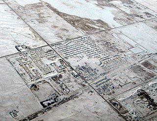
La Crete, also spelled La Crête, is a hamlet in northern Alberta, Canada, within Mackenzie County. It is located on Highway 697, approximately 57 kilometres (35 mi) southeast of High Level and 701 kilometres (436 mi) north of Edmonton.

Robb, Alberta Hamlet in Alberta, Canada

Robb is a hamlet in west-central Alberta, Canada within Yellowhead County that is recognized as a designated place by Statistics Canada. It is located on Highway 47, approximately 53 kilometres (33 mi) southwest of Edson. It has an elevation of 1,140 metres (3,740 ft).

Marlboro, Alberta Hamlet in Alberta, Canada

Marlboro is a hamlet in west-central Alberta, Canada within Yellowhead County. It is located on the Yellowhead Highway, approximately 25 kilometres (16 mi) west of Edson. Sundance Provincial Park is located northwest of the hamlet.

Cadomin Hamlet in Alberta, Canada

Cadomin is a hamlet in the west-central Alberta, Canada within Yellowhead County. It is located along the McLeod River in the foothills of the Rocky Mountains, approximately 50 kilometres (31 mi) south of Hinton near the Bighorn Highway. It is served by a spur of the Canadian National Railway.

Aetna, Alberta Hamlet in Alberta, Canada

Aetna is a hamlet in southern Alberta, Canada within Cardston County, located 2 kilometres (1.2 mi) east of Highway 2, approximately 70 kilometres (43 mi) southwest of Lethbridge.

Cardiff, Alberta Hamlet in Alberta, Canada

Cardiff is a hamlet in central Alberta, Canada within Sturgeon County. It is located 3 kilometres (1.9 mi) east of Highway 2, approximately 15 kilometres (9.3 mi) north of Edmonton's city limits. The Town of Morinville is 1.6 kilometres (0.99 mi) to the west of Cardiff.

East Coulee, Alberta Former hamlet in Alberta, Canada

East Coulee is a community within the Town of Drumheller, Alberta, Canada. It was previously a hamlet within the former Municipal District (MD) of Badlands No. 7 prior to the MD's amalgamation with the former City of Drumheller on January 1, 1998. It is also recognized as a designated place by Statistics Canada.

Nacmine, Alberta Former hamlet in Alberta, Canada

Nacmine is a community within the Town of Drumheller, Alberta, Canada. It was previously a hamlet within the former Municipal District (MD) of Badlands No. 7 prior to the MD's amalgamation with the former City of Drumheller on January 1, 1998.

Queenstown, Alberta Hamlet in Alberta, Canada

Queenstown is a hamlet in southern Alberta, Canada within Vulcan County. It is located approximately 26 kilometres (16 mi) south of Highway 1 and 92 kilometres (57 mi) southeast of Calgary.

Rosedale, Alberta Former hamlet in Alberta, Canada

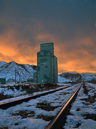
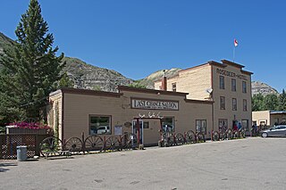
Rosedale is a community within the Town of Drumheller, Alberta, Canada. It was previously a hamlet within the former Municipal District (MD) of Badlands No. 7 prior to the MD's amalgamation with the former City of Drumheller on January 1, 1998. It is also recognized as a designated place by Statistics Canada.

Wayne, Alberta Former hamlet in Alberta, Canada

Wayne is a community within the Town of Drumheller, Alberta, Canada. It was previously a hamlet within the former Municipal District (MD) of Badlands No. 7 prior to the MD's amalgamation with the former City of Drumheller on January 1, 1998.

Newcastle, Alberta Former hamlet in Alberta, Canada

Newcastle is a community within the Town of Drumheller, Alberta, Canada. It held village status for eight years between 1923 and 1931, and was recognized as a hamlet prior to annexation by Drumheller in 1967. The community is located within the Red Deer River valley on South Dinosaur Trail, approximately 2 km (1.2 mi) west of Drumheller's main townsite. The former hamlet of Midlandvale is located across the river to the north.

Cambria, Alberta Former hamlet in Alberta, Canada

Cambria is a community within the Town of Drumheller, Alberta, Canada. It was previously a hamlet within the former Municipal District (MD) of Badlands No. 7 prior to the MD's amalgamation with the former City of Drumheller on January 1, 1998.

North Drumheller, Alberta Former hamlet in Alberta, Canada

North Drumheller is a community within the Town of Drumheller, Alberta, Canada. It was previously a hamlet within the former Municipal District of Badlands No. 7 prior to being annexed by Drumheller in 1967. The community is located within the Red Deer River valley at the intersection of Highway 9 and North Dinosaur Trail on the north side of the river across from Drumheller's main townsite.

Bankview, Alberta Former hamlet in Alberta, Canada

Bankview is a community within the Town of Drumheller, Alberta, Canada. It was previously a hamlet within the former Municipal District of Badlands No. 7 prior to being annexed by Drumheller in 1964. The community is located within the Red Deer River valley to the south of Drumheller's main townsite across Highway 9.

References

  1. 1 2 3 "2016 Census of Population: Hamlet of Clairmont" (PDF). Alberta Population. February 20, 2017. Retrieved December 5, 2021.
  2. "Specialized and Rural Municipalities and Their Communities" (PDF). Alberta Municipal Affairs. January 12, 2022. Retrieved January 21, 2022.
  3. 1 2 "Table 6: Population of census subdivisions, 1926-1946". 1946 Census of Alberta (PDF). Vol. Population. Ottawa: Dominion Bureau of Statistics. August 22, 1949. Retrieved December 5, 2021.
  4. Discover the Peace Country. "Clairmont" . Retrieved 2007-06-21.
  5. 1 2 South Peace Regional Archives (September 1, 2015). "100th Anniversary of Clairmont". Telling Our Stories. 6 (4): 5.
  6. "Township Notes/Field Plans". SpinII. Alberta Registries and Land Titles. Retrieved 5 October 2015.
  7. Sheehan, Beth (1992). Turn Back the Pages Clairmont 1908-1992. South Peace Regional Archives: Beth Sheehan. p. 21.
  8. "Post Offices and Postmasters". Library and Archives Canada. Government of Canada. Retrieved 5 October 2015.
  9. Sixth Census of Canada, 1921 (PDF). Vol. 1–Population. Dominion Bureau of Statistics. December 21, 1923. Retrieved December 5, 2021.
  10. Ninth Census of Canada, 1951 (PDF). Vol. SP-7 (Population: Unincorporated villages and hamlets). Dominion Bureau of Statistics. March 31, 1954. Retrieved December 5, 2021.
  11. Census of Canada, 1956 (PDF). Vol. Population of unincorporated villages and settlements. Dominion Bureau of Statistics. October 25, 1957. Retrieved December 5, 2021.
  12. 1961 Census of Canada: Population (PDF). Series SP: Unincorporated Villages. Vol. Bulletin SP—4. Ottawa: Dominion Bureau of Statistics. April 18, 1963. Retrieved December 5, 2021.
  13. Census of Canada 1966: Population (PDF). Special Bulletin: Unincorporated Places. Vol. Bulletin S–3. Ottawa: Dominion Bureau of Statistics. August 1968. Retrieved December 5, 2021.
  14. 1971 Census of Canada: Population (PDF). Special Bulletin: Unincorporated Settlements. Vol. Bulletin SP—1. Ottawa: Statistics Canada. March 1973. Retrieved December 5, 2021.
  15. "Geographical Identification and Population for Unincorporated Places of 25 persons and over, 1971 and 1976". 1976 Census of Canada (PDF). Supplementary Bulletins: Geographic and Demographic (Population of Unincorporated Places—Canada). Vol. Bulletin 8SG.1. Ottawa: Statistics Canada. May 1978. Retrieved December 5, 2021.
  16. 1981 Census of Canada (PDF). Place name reference list. Vol. Western provinces and the Territories. Ottawa: Statistics Canada. May 1983. Retrieved December 5, 2021.
  17. 1986 Census of Canada (PDF). Population. Vol. Unincorporated Places. Ottawa: Statistics Canada. July 1988. Retrieved December 5, 2021.
  18. 91 Census (PDF). Population and Dwelling Counts. Vol. Unincorporated Places. Ottawa: Statistics Canada. June 1993. Retrieved December 5, 2021.
  19. 96 Census (PDF). A National Overivew: Population and Dwelling Counts. Ottawa: Statistics Canada. April 1997. Retrieved December 5, 2021.
  20. "Population and Dwelling Counts, for Canada, Provinces and Territories, and Census Divisions, 2001 and 1996 Censuses - 100% Data (Alberta)". Statistics Canada. August 15, 2012. Retrieved December 5, 2021.
  21. 1 2 County of Grande Prairie No. 1. "Economic Profile" (PDF). Retrieved January 10, 2010.[ permanent dead link ]

Coordinates: 55°15′41″N118°47′37″W / 55.26139°N 118.79361°W / 55.26139; -118.79361 (Clairmont)