
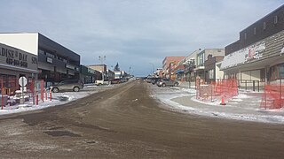
The Municipality of Crowsnest Pass is a specialized municipality in southwest Alberta, Canada. Within the Rocky Mountains adjacent to the eponymous Crowsnest Pass, the municipality formed as a result of the 1979 amalgamation of five municipalities – the Village of Bellevue, the Town of Blairmore, the Town of Coleman, the Village of Frank, and Improvement District No. 5, which included the Hamlet of Hillcrest and numerous other unincorporated communities.

Exshaw is a hamlet in Alberta, Canada within Municipal District (MD) of Bighorn No. 8. Located approximately 90 kilometres (56 mi) west of downtown Calgary and 15 kilometres (9.3 mi) east of Canmore, Exshaw is situated within the Bow River valley north of the Bow River.
Rocky Mountain House is a town in west-central Alberta, Canada. It is approximately 77 km (48 mi) west of Red Deer at the confluence of the Clearwater and North Saskatchewan Rivers, and at the crossroads of Highway 22 and Highway 11. The surrounding Clearwater County's administration office is located in Rocky Mountain House.
Granum is a hamlet in southern Alberta, Canada that is under the jurisdiction of the Municipal District of Willow Creek No. 26. It is located at the junction of Highway 2 and Highway 519 west of Lethbridge. Incorporated as the Village of Leavings in 1904, it changed its name to Granum in 1908 and held town status between late 1910 and early 2020.
Diamond City is a hamlet in southern Alberta, Canada within the Lethbridge County. It is located on Highway 25, approximately 13 kilometres (8.1 mi) north of Lethbridge. The community was so named on account of deposits of coal near the original town site, a resource also called "black diamond".
Hillcrest, also known as Hillcrest Mines, is an urban community in the Rocky Mountains within the Municipality of Crowsnest Pass in southwest Alberta, Canada. It was once a hamlet under the jurisdiction of Improvement District (ID) No. 5 prior to 1979 when the former ID No. 5 amalgamated with four other municipalities to form Crowsnest Pass.
Keoma is a hamlet in southern Alberta under the jurisdiction of Rocky View County.
Langdon is a hamlet in southern Alberta, Canada under the jurisdiction of Rocky View County. It previously held village status between August 31, 1907, and January 1, 1946.
Cochrane Lake is a hamlet in southern Alberta under the jurisdiction of Rocky View County. Statistics Canada also recognizes a smaller portion of the hamlet as a designated place under the name of Cochrane Lake Subdivision.
Dalemead is a hamlet in southern Alberta under the jurisdiction of Rocky View County. It is approximately 35 km (21 mi) southeast of Downtown Calgary and 3.2 km (2.0 mi) south of Highway 22X along a Canadian Pacific Railway line.

Nordegg is a hamlet in west-central Alberta, Canada within Clearwater County. It is in the North Saskatchewan River valley in the foothills of the Canadian Rockies, just east of the intersection of the David Thompson Highway and the Highway 734 spur of the Bighorn Highway. A former coal mining town, it was named after Martin Nordegg and the name probably means "North Corner" in a German dialect. The railway station name at the locality was called Brazeau rather than Nordegg at certain points in its history, but the local post office has always been named Nordegg. The name Brazeau is now obsolete.

Cadomin is a hamlet in the west-central Alberta, Canada within Yellowhead County. It is located along the McLeod River in the foothills of the Rocky Mountains, approximately 50 kilometres (31 mi) south of Hinton near the Bighorn Highway. It is served by a spur of the Canadian National Railway.
Woolford is a hamlet in southern Alberta, Canada within Cardston County. It is located on Highway 503, approximately 16 kilometres (9.9 mi) southeast of Cardston between the St. Mary River and the Milk River Ridge. It is named after Thomas Woolford who came to the area in 1900.
Alhambra is a hamlet in Alberta, Canada within Clearwater County. It is located close to the David Thompson Highway, east of Rocky Mountain House.
Mountain View is a hamlet in Alberta, Canada within Cardston County. It is located along Highway 5 approximately 25 kilometres (16 mi) west of Cardston and 20 kilometres (12 mi) east of Waterton Lakes National Park near the United States border. It is also a kickoff point for visitors to Police Outpost Provincial Park, 18 kilometers to the south.
Leslieville is a hamlet in Alberta, Canada within Clearwater County. It is located east of Rocky Mountain House along the Canadian National Railway and has an elevation of 965 metres (3,166 ft).
Aetna is a hamlet in southern Alberta, Canada within Cardston County, located 2 kilometres (1.2 mi) east of Highway 2, approximately 70 kilometres (43 mi) southwest of Lethbridge.
Chinook is a hamlet in southern Alberta, Canada within Special Area No. 3. It is located on Highway 9 approximately 119 kilometres (74 mi) northeast of Brooks.
Dead Man's Flats is a hamlet in Alberta within the Municipal District of Bighorn No. 8. Statistics Canada also recognizes it as a designated place under the name of Pigeon Mountain. It is located within Alberta's Rockies at Highway 1 exit 98, approximately 7 kilometres (4.3 mi) southeast of Canmore and 78 kilometres (48 mi) west of Calgary.
Withrow is a hamlet in central Alberta, Canada within Clearwater County. It is located on a Canadian National rail line and Withrow Road, 8 km (5.0 mi) north of Highway 11 and 8 km (5.0 mi) south of Highway 12. It is approximately 15 km (9.3 mi) east of Rocky Mountain House.
