
Bragg Creek is a hamlet in southern Alberta under the jurisdiction of Rocky View County in Division No. 6.

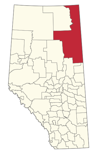
Division No. 6 is a census division in Alberta, Canada. It includes the City of Calgary and surrounding areas. The majority of the division consists of Alberta's Calgary Region, while the northern portion of the division includes parts of central Alberta. The division also forms the southern segment of the Calgary–Edmonton Corridor. Division No. 6 is the largest census division in Alberta according to population and also has the highest population density.
The Regional Municipality of Wood Buffalo is a specialized municipality in northeast Alberta, Canada. It is the largest regional municipality in Canada by area and is home to oil sand deposits known as the Athabasca oil sands.

The Municipality of Crowsnest Pass is a specialized municipality in southwest Alberta, Canada. Within the Rocky Mountains adjacent to the eponymous Crowsnest Pass, the municipality formed as a result of the 1979 amalgamation of five municipalities – the Village of Bellevue, the Town of Blairmore, the Town of Coleman, the Village of Frank, and Improvement District No. 5, which included the Hamlet of Hillcrest and numerous other unincorporated communities.

Sundre is a town in central Alberta, Canada that is surrounded by Mountain View County. It is approximately 100 km (62 mi) northwest of Calgary on the Cowboy Trail in the foothills of the Canadian Rockies.

Rocky View County is a municipal district in southern Alberta, Canada that is named for its views of the nearby Rocky Mountains to the west. It surrounds most of Calgary, forming the city's northern boundary and most of the city's western and eastern boundaries. At a population of 41,028 in 2021, Rocky View County is the most populous municipal district in Alberta. Though predominantly rural in nature, Rocky View County is home to 14 hamlets, including Langdon, one of Alberta's most populous hamlets. Its rural areas are home to numerous country residential subdivisions.

Red Deer County is a municipal district in central Alberta, Canada within Census Division No. 8 and surrounding the City of Red Deer. The neighbouring municipalities of Red Deer County are Clearwater County to the west, Lacombe County to the north, the County of Stettler No. 6 to the east, Kneehill County to the southeast and Mountain View County to the south. It is located approximately midway between Edmonton and Calgary, bisected by the Queen Elizabeth II Highway and bounded on the north and east by the Red Deer River.

Clearwater County is a municipal district in west central Alberta, Canada in Division No. 9. Its northwest boundary is the Brazeau River. The municipal office is located in the Town of Rocky Mountain House. The county has a land area of 18,691.65 km2 (7,216.89 sq mi) and comprises close to 99% of Census Division No. 9's land area of 18,921.38 km2 (7,305.59 sq mi). Although the territory excluded is rather small in geographical area, it comprises the major population centre of Rocky Mountain House, which has one-third of Division No. 9's population, in addition to the communities of Burnstick Lake and three Indian reserves. Clearwater County's 2021 census population was 11,865, which was prior to amalgamation with Caroline in 2025.
Division No. 16 is a census division in Alberta, Canada. It is located in the northeast portion of northern Alberta and surrounds the Urban Service Area of Fort McMurray.

Caroline is a hamlet in central Alberta, Canada that is under the jurisdiction of Clearwater County. It held village status prior to 2025. Caroline is southwest of Red Deer.
Keoma is a hamlet in southern Alberta under the jurisdiction of Rocky View County.

Cochrane Lake is a hamlet in southern Alberta under the jurisdiction of Rocky View County. Statistics Canada also recognizes a smaller portion of the hamlet as a designated place under the name of Cochrane Lake Subdivision.
Dalemead is a hamlet in southern Alberta under the jurisdiction of Rocky View County. It is approximately 35 km (21 mi) southeast of Downtown Calgary and 3.2 km (2.0 mi) south of Highway 22X along a Canadian Pacific Kansas City railway line.

Beaver Mines is a hamlet in southern Alberta, Canada within the Municipal District of Pincher Creek No. 9. It is located in the foothills of the Canadian Rockies on Highway 507, approximately 19 km (12 mi) west of Pincher Creek.

Cadomin is a hamlet in west-central Alberta, Canada, within Yellowhead County. It is along the McLeod River in the foothills of the Rocky Mountains, approximately 50 kilometres (31 mi) south of Hinton near the Bighorn Highway. It is served by a spur of the Canadian National Railway.
Alhambra is a hamlet in Alberta, Canada within Clearwater County. It is located close to the David Thompson Highway, east of Rocky Mountain House.
Sandy Lake, also known as Pelican Mountain, is a hamlet in Alberta, Canada within the Municipal District of Opportunity No. 17. It is located on Highway 813, between Calling Lake and Wabasca. It has an elevation of 565 metres (1,854 ft).
Leslieville is a hamlet in Alberta, Canada within Clearwater County. It is located east of Rocky Mountain House along the Canadian National Railway and has an elevation of 965 metres (3,166 ft).
Brownvale is a hamlet in northern Alberta, Canada within the Municipal District of Peace No. 135. It is located on Highway 737 less than 1 kilometre (0.62 mi) off Highway 2, approximately 48 kilometres (30 mi) southwest of the Town of Peace River and 20 kilometres (12 mi) southwest of Grimshaw. Duncan's First Nation reserve is less than 5 km (3.1 mi) to the south.
Long Lake is a hamlet in central Alberta, Canada within Thorhild County. It is located on the west shore of Long Lake, approximately 12 kilometres (7.5 mi) east of Highway 63 and 114 kilometres (71 mi) northeast of Edmonton.
