
Torrington is a hamlet in central Alberta, Canada within Kneehill County. It is approximately 160 kilometres (99 mi) northeast of Calgary at the junction of Highway 27 and Highway 805.

Chipman is a village in central Alberta, Canada within Lamont County and Census Division No. 10. It is located on Highway 15, approximately 11 km (7 mi) southeast of Lamont, 22 km (14 mi) northwest of Mundare, 70 km (44 mi) east of Edmonton, and 30 km (18 mi) northeast of the Yellowhead Highway entrance to Elk Island National Park.
Star is a hamlet in central Alberta, Canada within Lamont County. It is located on Highway 831, approximately 5 kilometres (3.1 mi) north of Lamont and 8 kilometres (5.0 mi) south of Highway 45.
Blue Ridge is a hamlet in northwest Alberta, Canada within Woodlands County. It is located on Highway 658, 7 kilometres (4.3 mi) north of Highway 43 and 3 kilometres (1.9 mi) south of the Athabasca River. It is midway between the towns of Whitecourt and Mayerthorpe and approximately 159 kilometres (99 mi) northwest of Edmonton.

Lamont County is a municipal district in central Alberta, Canada, located in Census Division No. 10, northeast of Edmonton. The county contains 27 Townships. Its municipal office is located in the Town of Lamont.
Turin is a hamlet in Alberta, Canada within the Lethbridge County. It is located approximately 56 kilometres (35 mi) northeast of Lethbridge on Highway 25 and along a Canadian Pacific Railway line.
Byemoor is a hamlet in Alberta, Canada within the County of Stettler No. 6. It is located at the intersection of Highway 853 and Highway 589, approximately 70 kilometres (43 mi) southeast of Stettler and 80 kilometres (50 mi) northeast of Drumheller. It has an elevation of 845 metres (2,772 ft).

Wildwood is a hamlet in west-central Alberta, Canada within Yellowhead County. It is on the Yellowhead Highway, approximately 112 kilometres (70 mi) west of Edmonton and 82 kilometres (51 mi) east of Edson. The Yellowhead Highway's intersection with Cowboy Trail is 9 kilometres (5.6 mi) east of the hamlet. The Lobstick River, which flows from Chip Lake to the west, runs through the hamlet.

Wrentham is a hamlet in southern Alberta, Canada within the County of Warner No. 5. It is located southeast of the intersection of the Veteran Memorial Highway and the historic Red Coat Trail, approximately 25 kilometres (16 mi) east of the Village of Stirling, 30 kilometres (19 mi) south of the Town of Taber and 55 kilometres (34 mi) west of the Village of Foremost.
Gainford is a hamlet in Alberta, Canada within Parkland County. It is located approximately 86 kilometres (53 mi) west of Edmonton and has an elevation of 740 metres (2,430 ft).

Cherhill is a hamlet in Alberta, Canada within Lac Ste. Anne County. It is located along Highway 43, approximately 35 kilometres (22 mi) east of Mayerthorpe and 82 kilometres (51 mi) northwest of Edmonton.
Armena is a hamlet in Alberta, Canada within Camrose County. It is located approximately 21 kilometres (13 mi) northwest of Camrose along Highway 21 and has an elevation of 745 metres (2,444 ft).
Cadogan is a hamlet in central Alberta, Canada within the Municipal District of Provost No. 52. Previously an incorporated municipality, Cadogan dissolved from village status on January 1, 1946 to become part of the Municipal District of Hillcrest No. 362.

Chancellor is a hamlet in southern Alberta, Canada within Wheatland County. It is located approximately 26 kilometres (16 mi) north of Highway 1 and 86 kilometres (53 mi) east of Calgary.
Hilliard is a hamlet in central Alberta, Canada within Lamont County. It is located on Highway 15, approximately 68 kilometres (42 mi) east of Edmonton.
Musidora is a hamlet in central Alberta, Canada within the County of Two Hills No. 21. It is located on Highway 45, approximately 112 kilometres (70 mi) northwest of Lloydminster.
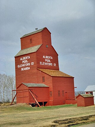
Scandia is a hamlet in Alberta, Canada within the County of Newell. It is located 2 kilometres (1.2 mi) west of Highway 36, approximately 34 kilometres (21 mi) southwest of Brooks.
St. Michael is a hamlet in central Alberta, Canada within Lamont County. It is located 6 kilometres (3.7 mi) north of Highway 29, approximately 42 kilometres (26 mi) northeast of Fort Saskatchewan.
Sunnynook is a hamlet in southern Alberta, Canada within Special Area No. 2. It is located approximately 10 kilometres (6.2 mi) east of Highway 36 and 86 kilometres (53 mi) northeast of Brooks. The hamlet formerly housed the Berry Creek Community School Division office and area post office until amalgamation of the school division into Prairie Land Regional Division.
Whitford is a hamlet in central Alberta, Canada within Lamont County. It is located 1 kilometre (0.62 mi) west of Highway 45, approximately 68 kilometres (42 mi) northeast of Fort Saskatchewan. The first school was built in 1895 with John and Andrew Whitford as trustees.

