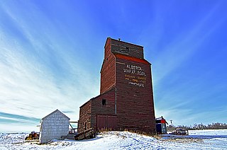
Acadia Valley

Last updated
Acadia Valley
Acadia Valley, Alberta (9544306976).jpg
0001 Municipal District of Acadia No. 34.svg
Red pog.svg
Location in M.D. of Acadia
Alberta County Point Locator.svg
Red pog.svg
Location in Alberta
Coordinates: 51°09′25″N110°12′35″W / 51.1569°N 110.2097°W / 51.1569; -110.2097
CountryCanada
Province Alberta
Planning region Red Deer
Municipal district M.D. of Acadia No. 34
Government
  Type Unincorporated
  Governing body M.D. of Acadia No. 34 Council
Area
 (2021) [1]
  Land0.46 km2 (0.18 sq mi)
Elevation
[2]
716 m (2,349 ft)
Population
 (2021) [1]
  Total143
  Density308.1/km2 (798/sq mi)
Time zone UTC−7 (MST)
  Summer (DST) UTC−6 (MDT)

Acadia Valley is a hamlet in southeast Alberta, Canada within the Municipal District (MD) of Acadia No. 34. [3] The MD of Acadia No. 34's municipal office is located in Acadia Valley.

Contents

Acadia Valley is located along Highway 41 commonly referred to as Buffalo Trail between Oyen and Medicine Hat and sits about 14.5 km (9.0 mi) west of the Alberta-Saskatchewan border. Acadia Valley sits at an elevation of 716 m (2,349 ft).

The hamlet is located within census division No. 4. It was named in 1910 by settlers from Nova Scotia. [4]

Demographics

In the 2021 Census of Population conducted by Statistics Canada, Acadia Valley had a population of 143 living in 71 of its 86 total private dwellings, a change of

As a designated place in the 2016 Census of Population conducted by Statistics Canada, Acadia Valley had a population of 149 living in 71 of its 82 total private dwellings, a change of

Attractions

See also

Related Research Articles

Seven Persons Hamlet in Alberta, Canada

Seven Persons is a hamlet in Alberta, Canada within Cypress County. It is located approximately 20 kilometres (12 mi) southwest of Medicine Hat on Highway 3 and has an elevation of 755 metres (2,477 ft).

Ohaton is a hamlet in central Alberta, Canada within Camrose County. Previously an incorporated municipality, Ohaton dissolved from village status on January 1, 1946.

Tawatinaw is a hamlet in Alberta, Canada within Westlock County. It is located on Township Road 614, 2 kilometres (1.2 mi) east of Highway 2 and approximately 70 kilometres (43 mi) north of the City of Edmonton.

Torrington, Alberta Hamlet in Alberta, Canada

Torrington is a hamlet in central Alberta, Canada within Kneehill County. It is located approximately 160 kilometres (99 mi) northeast of Calgary at the junction of Highway 27 and Highway 805.

Ferintosh is a hamlet in central Alberta, Canada within Camrose County. It is located approximately 38 kilometres (24 mi) south of Camrose, and 102 kilometres (63 mi) southeast of Edmonton. The hamlet is situated on Little Beaver Lake. The community takes its name from Ferintosh, in Scotland.

Municipal District of Acadia No. 34 Municipal district in Alberta, Canada

The Municipal District of Acadia No. 34 is a municipal district (MD) in southern Alberta, Canada, east of Calgary, close to the Saskatchewan border, in Census Division No. 4.

Atmore, Alberta Hamlet in Alberta, Canada

Atmore is a hamlet in Alberta, Canada within Athabasca County. It is located 1 km (0.62 mi) east of the junction of Highway 55 and Highway 63, 43 km (27 mi) west of Lac La Biche, 54 km (34 mi) east of Athabasca and 250 km (160 mi) south of Fort McMurray.

Brule is a hamlet in west-central Alberta, Canada within Yellowhead County. It is located on the northwest shore of Brûlé Lake, approximately 20 kilometres (12 mi) west of Hinton. It has an elevation of 1,040 metres (3,410 ft).

Grassy Lake, Alberta Hamlet in Alberta, Canada

Grassy Lake is a hamlet in Alberta, Canada within the Municipal District of Taber. It is located on the Crowsnest Highway (Highway 3), midway between the cities of Lethbridge to the west and Medicine Hat to the east. It is approximately 13 km (8.1 mi) west of Burdett and 34 km (21 mi) east of Taber. It has an elevation of 810 metres (2,660 ft). It was formerly incorporated as a village, dissolving into the Municipal District of Taber on July 1, 1996.

Red Willow is a hamlet in central Alberta, Canada within the County of Stettler No. 6. It is located on Highway 850, approximately 16 kilometres (9.9 mi) northeast of Stettler and 14 kilometres (8.7 mi) south of Donalda. It has an elevation of 785 metres (2,575 ft).

Antler Lake Hamlet in Alberta, Canada

Antler Lake is a hamlet in Alberta, Canada within Strathcona County. It is located on the shores of Antler Lake on Range Road 211 and 211A just north of Wye Road, approximately 18 km (11 mi) east of Sherwood Park and 25 km (16 mi) northwest of Tofield.

Collingwood Cove is a hamlet in Alberta, Canada within Strathcona County. It is located at the terminus of Highway 629, approximately 17 kilometres (11 mi) southeast of Sherwood Park.

Half Moon Lake, Alberta Hamlet in Alberta, Canada

Half Moon Lake is a hamlet in Alberta, Canada within Strathcona County. It is also recognized as a designated place by Statistics Canada under the name of Half Moon Estates. The community is located on the shores of Half Moon Lake, just north of Highway 629, approximately 13 kilometers (8.1 mi) southeast of Sherwood Park.

Round Hill is a hamlet in central Alberta, Canada within Camrose County. It is located on Highway 834 approximately 29 kilometres (18 mi) northeast of Camrose and has an elevation of 740 metres (2,430 ft).

Buck Lake is a hamlet in central Alberta, Canada within the County of Wetaskiwin No. 10. It is located on Highway 13, approximately 109 kilometres (68 mi) southwest of Edmonton. It is located on the shore of Buck Lake.

Egremont is a hamlet in central Alberta, Canada within Thorhild County. It is located 2 kilometres (1.2 mi) north of Highway 28, approximately 37 kilometres (23 mi) north of Fort Saskatchewan. It is named after Egremont, Cumbria.

Jarvie is a hamlet in central Alberta, Canada within Westlock County. It is located 0.6 kilometres (0.37 mi) west of Highway 44, approximately 108 kilometres (67 mi) northwest of Edmonton. Jarvie is on the bank of the Pembina River, with the Canadian Northern Railway directly east to the townsite. In June 2020, the Jarvie General Store was destroyed by a fire, the store had been in operation for at least 110 years.

Lowland Heights is a hamlet in southern Alberta, Canada within the Municipal District of Pincher Creek No. 9. It is located on Highway 6, approximately 83 kilometres (52 mi) southwest of Lethbridge.

Whitelaw is a hamlet in northern Alberta, Canada within the Municipal District of Fairview No. 136. It is located 2 kilometres (1.2 mi) north of Highway 2, approximately 114 kilometres (71 mi) northeast of Grande Prairie.

Johnson's Addition is a hamlet in southern Alberta, Canada within the Municipal District of Taber. It is adjacent to the western boundary of the Town of Taber at the intersection of Highway 3 and Highway 864.

References

  1. 1 2 3 "Population and dwelling counts: Canada and designated places". Statistics Canada. February 9, 2022. Retrieved February 10, 2022.
  2. "Alberta Private Sewage Systems 2009 Standard of Practice Handbook: Appendix A.3 Alberta Design Data (A.3.A. Alberta Climate Design Data by Town)" (PDF) (PDF). Safety Codes Council. January 2012. pp. 212–215 (PDF pages 226–229). Archived from the original (PDF) on October 16, 2013. Retrieved October 8, 2013.
  3. "Specialized and Rural Municipalities and Their Communities" (PDF). Alberta Municipal Affairs. January 12, 2022. Retrieved January 21, 2022.
  4. Hamilton, William (1978). The Macmillan Book of Canadian Place Names. Toronto: Macmillan. p. 20. ISBN   0-7715-9754-1.
  5. "Population and dwelling counts, for Canada, provinces and territories, and designated places, 2016 and 2011 censuses – 100% data (Alberta)". Statistics Canada. February 8, 2017. Retrieved February 13, 2017.
  6. M.D. of Acadia No. 34 - Points of Interest

Coordinates: 51°09′25″N110°12′35″W / 51.15694°N 110.20972°W / 51.15694; -110.20972 (Acadia Valley)