Tawatinaw is a hamlet in Alberta, Canada within Westlock County. It is located on Township Road 614, 2 kilometres (1.2 mi) east of Highway 2 and approximately 70 kilometres (43 mi) north of the City of Edmonton.
Mayerthorpe is a town in central Alberta, Canada. It is approximately 120 km (75 mi) northwest of Edmonton at the intersection of Highway 43 and Highway 22. The town is surrounded by Lac Ste. Anne County and is in Alberta's Census Division No. 13.
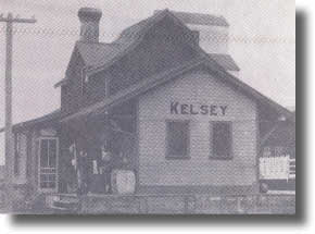
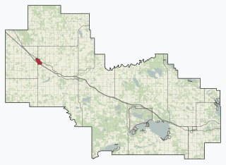
Kelsey is a hamlet in central Alberta, Canada within Camrose County. It is located off Highway 850, approximately 125 kilometres (78 mi) southeast of Edmonton and 30 kilometres (19 mi) southeast of Camrose, Kelsey's closest major trading centre.
Minburn is a hamlet in central, Alberta, Canada within the County of Minburn No. 27. It is located on the Yellowhead Highway and the Canadian National Railway, approximately 37 km (23 mi) west of the Town of Vermilion and 143 km (89 mi) east of the City of Edmonton.

Wildwood is a hamlet in west-central Alberta, Canada within Yellowhead County. It is on the Yellowhead Highway, approximately 112 kilometres (70 mi) west of Edmonton and 82 kilometres (51 mi) east of Edson. The Yellowhead Highway's intersection with Cowboy Trail is 9 kilometres (5.6 mi) east of the hamlet. The Lobstick River, which flows from Chip Lake to the west, runs through the hamlet.
Calling Lake is a hamlet in northern Alberta, Canada within the Municipal District of Opportunity No. 17. It is located on Highway 813 along the eastern shore of Calling Lake, immediately north of Calling Lake Provincial Park. It is approximately 59 km (37 mi) north of Athabasca and 113 km (70 mi) south of Wabasca and has an elevation of 595 m (1,952 ft).

Valhalla Centre is a hamlet in northern Alberta, Canada within the County of Grande Prairie No. 1.

Red Earth Creek is a hamlet in Alberta, Canada within the Municipal District of Opportunity No. 17. It is located east of Highway 88, between the town of Slave Lake and the hamlet of Fort Vermilion, and has an elevation of 520 metres (1,710 ft).
La Glace is a hamlet in northern Alberta, Canada within the County of Grande Prairie No. 1. It is located along Highway 59 between Sexsmith and Valhalla Centre and has an elevation of 735 metres (2,411 ft).
Warspite is a hamlet in Alberta, Canada within Smoky Lake County. It is located on Highway 28, between the Town of Smoky Lake and Village of Waskatenau. It has an elevation of 655 metres (2,149 ft).
Morningside is a hamlet in central Alberta, Canada within Lacombe County. It is located just east of Highway 2 at the intersection of Highway 2A and Highway 604, approximately 36 kilometres (22 mi) north of Red Deer.
Alder Flats is a hamlet in central Alberta, Canada within the County of Wetaskiwin No. 10. It is located 8 kilometres (5.0 mi) west of Highway 22 at the western terminus of Highway 13, approximately 120 kilometres (75 mi) southwest of Edmonton.
Carbondale is a hamlet in central Alberta, Canada within Sturgeon County. It is located 2 kilometres (1.2 mi) west of Highway 28, approximately 11 kilometres (6.8 mi) north of Edmonton's city limits.
Linn Valley is a hamlet in central Alberta, Canada within Red Deer County. It is located on Highway 11A, approximately 7 kilometres (4.3 mi) northwest of Red Deer.
Nestow is a hamlet in central Alberta, Canada within Westlock County. It is located on Highway 2, approximately 78 kilometres (48 mi) north of Edmonton.
Patricia is a hamlet in southern Alberta, Canada within the County of Newell. It is located approximately 20 kilometres (12 mi) north of Highway 1 and 21 kilometres (13 mi) northeast of Brooks.
Telfordville is a hamlet in central Alberta, Canada within Leduc County. It is located just off Highway 622, approximately 41 kilometres (25 mi) west of Leduc. It is named for Robert Telford, former Leduc mayor and member of the Legislative Assembly of Alberta.
Tillicum Beach is a hamlet in central Alberta, Canada within Camrose County. It is 3 kilometres (1.9 mi) west Highway 56, approximately 16 kilometres (9.9 mi) southeast of Camrose. It is located along Dried Meat Lake.
Veinerville is a hamlet in southern Alberta, Canada within Cypress County. It is located 0.5 kilometres (0.31 mi) northwest of Highway 41A, and less than 150 metres (490 ft) from Medicine Hat's east boundary.
Fairview is a hamlet in southern Alberta, Canada within Lethbridge County. It is adjacent to the eastern boundary of Lethbridge, approximately 0.3 kilometres (0.19 mi) south of Highway 3. More specifically, it is located on southeast corner of Highway 4 and Highway 512.

