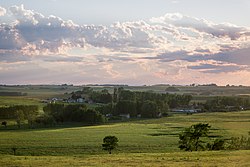
Rocky View County is a municipal district in southern Alberta, Canada that is named for its views of the nearby Rocky Mountains to the west. It surrounds most of Calgary, forming the city's northern boundary and most of the city's western and eastern boundaries. At a population of 41,028 in 2021, Rocky View County is the most populous municipal district in Alberta. Though predominantly rural in nature, Rocky View County is home to 14 hamlets, including Langdon, one of Alberta's most populous hamlets. Its rural areas are home to numerous country residential subdivisions.

Irricana is a town in the Calgary Metropolitan Region of Alberta, Canada. Surrounded by Rocky View County, it is adjacent to Highway 9, approximately 53 kilometres (33 mi) northeast of Calgary.

Torrington is a hamlet in central Alberta, Canada within Kneehill County. It is approximately 160 kilometres (99 mi) northeast of Calgary at the junction of Highway 27 and Highway 805.
Crossfield is a town in the Calgary Metropolitan Region of Alberta, Canada that is surrounded by Rocky View County. It is located on Highway 2A 43 km (27 mi) north of the City of Calgary.
Kathyrn is a hamlet in southern Alberta under the jurisdiction of Rocky View County.
Keoma is a hamlet in southern Alberta under the jurisdiction of Rocky View County.

Cochrane Lake is a hamlet in southern Alberta under the jurisdiction of Rocky View County. Statistics Canada also recognizes a smaller portion of the hamlet as a designated place under the name of Cochrane Lake Subdivision.
Conrich is a hamlet in southern Alberta under the jurisdiction of Rocky View County.
Dalemead is a hamlet in southern Alberta under the jurisdiction of Rocky View County. It is approximately 35 km (21 mi) southeast of Downtown Calgary and 3.2 km (2.0 mi) south of Highway 22X along a Canadian Pacific Kansas City railway line.
Dalroy is a hamlet in southern Alberta under the jurisdiction of Rocky View County. It is located approximately 28 km (18 mi) east of Downtown Calgary and 0.8 km (0.5 mi) east of Highway 9.
Delacour is a hamlet in southern Alberta under the jurisdiction of Rocky View County. It is located approximately 10 km (6.2 mi) east of the City of Calgary, and 24 km (15 mi) from its downtown. The hamlet features a creek valley setting and a golf club.
Indus is a hamlet in southern Alberta, Canada under the jurisdiction of Rocky View County. It is home to the Bill Herron Arena
Cayley is a hamlet in southern Alberta, Canada within the Foothills County. It is also recognized as a designated place by Statistics Canada.
Cheadle is a hamlet in Alberta, Canada within Wheatland County. It is located on Highway 24, 2 kilometers (1.2 mi) south of the Highway 1 and approximately 35 kilometers (22 mi) east of the City of Calgary.
Swalwell is a hamlet in southern Alberta, Canada within Kneehill County. Previously an incorporated municipality, Swalwell dissolved from village status on January 1, 1946, to become part of the Municipal District of Norquay No. 279.
Gainford is a hamlet in Alberta, Canada within Parkland County. It is located approximately 86 kilometres (53 mi) west of Edmonton and has an elevation of 740 metres (2,430 ft).
Cluny is a hamlet in Alberta, Canada within Wheatland County. It is 3 kilometres (1.9 mi) south of Highway 1 on a Canadian Pacific Kansas City railway line and Highway 843, approximately 87 kilometres (54 mi) southeast of Calgary. It has an elevation of 570 metres (1,870 ft).
Dead Man's Flats is a hamlet within the Municipal District of Bighorn No. 8. Statistics Canada also recognizes it as a designated place under the name of Pigeon Mountain. It is located within Alberta's Rockies at Highway 1 exit 98, approximately 7 kilometres (4.3 mi) southeast of Canmore and 78 kilometres (48 mi) west of Calgary.
Nightingale is a hamlet in southern Alberta, Canada within Wheatland County. It is located 4 kilometres (2.5 mi) west of Highway 21, approximately 53 kilometres (33 mi) east of Calgary.
Rolly View is a hamlet in Central Alberta, Canada, within Leduc County. It is located approximately 11 kilometres (6.8 mi) west of Highway 21 and 16 kilometres (9.9 mi) east of Leduc on Highway 623 at Range Road 324.
Karamitsanis, Aphrodite (1992). Place Names of Alberta – Volume II, Southern Alberta, University of Calgary Press, Calgary, Alberta.