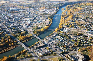
Red Deer is a city in Central Alberta, Canada. It is located near the midpoint of the Calgary–Edmonton Corridor and is surrounded by Red Deer County. It is Alberta's fourth most populous city – after Calgary, Edmonton, and Lethbridge – based on 2019 municipal census data. The city is located in aspen parkland, a region of rolling hills that is home to oil, grain, and cattle production. It is a centre for oil and agriculture distribution, and the surrounding region is a major centre for petrochemical production. With a recorded population of 100,418 in the Canada 2016 census, Red Deer became the third Alberta city to surpass 100,000 people.

Sylvan Lake is a town in central Alberta, Canada. It is located 25 kilometres (16 mi) west of the City of Red Deer along Highway 11 or Highway 11A. It is situated on the southeast edge of Sylvan Lake, a 15-kilometre-long (9.3 mi) freshwater lake, in Red Deer County.

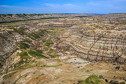
Drumheller is a town within the Red Deer River valley in the badlands of east-central Alberta, Canada. It is located 110 kilometres (68 mi) northeast of Calgary. The Drumheller portion of the Red Deer River valley, often referred to as Dinosaur Valley, has an approximate width of 2 kilometres (1.2 mi) and an approximate length of 28 kilometres (17 mi).
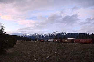
Jasper is a specialized municipality in western Alberta, Canada. It is the commercial centre of Jasper National Park, located in the Canadian Rockies within the Athabasca River valley. Jasper is approximately 362 kilometres (225 mi) west of Edmonton and 290 kilometres (180 mi) north of Banff, Alberta, at the intersection of Highway 16 and Highway 93.

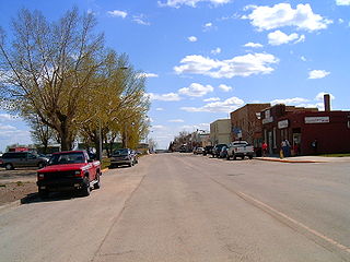
Penhold is a town in central Alberta, Canada. Penhold is surrounded by the county of Red Deer No. 23, 16 km (9.9 mi) south of Red Deer at the junction of Highway 2A and Highway 42. It is located 128 kilometres (80 mi) north of Calgary, along the Red Deer River Home of Penhold Football (Soccer) Team 2015 Penhold Oxfurds, 2016 Penhold Stars Silver place winners

Olds is a town on the Calgary–Edmonton Corridor, in the Canadian province of Alberta. It is situated in central Alberta within Mountain View County; located 61 km (38 mi) south of the nearest city, Red Deer and 90 km (56 mi) north of Calgary. The nearest towns are Didsbury to the south, Bowden to the north, Sundre to the west and Three Hills to the east. The town meets in an intersection between Highway 27 and Highway 2A, 5 km (3.1 mi) west of the Queen Elizabeth II Highway. The Canadian Pacific Railway's main Edmonton–Calgary line runs through the town.

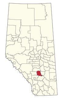
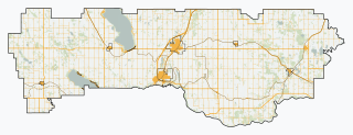
Red Deer County is a municipal district in central Alberta, Canada within Census Division No. 8 and surrounding the City of Red Deer. The neighbouring municipalities of Red Deer County are Clearwater County to the west, Lacombe County to the north, the County of Stettler No. 6 to the east, Kneehill County to the southeast and Mountain View County to the south. It is located approximately midway between Edmonton and Calgary, bisected by the Queen Elizabeth II Highway and bounded on the north and east by the Red Deer River.

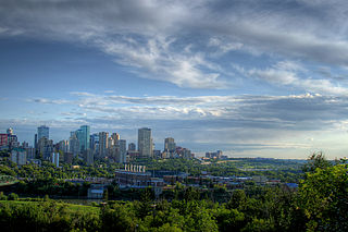
The Edmonton Metropolitan Region (EMR), also commonly referred to as the Alberta Capital Region, Greater Edmonton or Metro Edmonton, is a conglomeration of municipalities centred on Alberta's provincial capital of Edmonton.
Blackfalds is a town in central Alberta, Canada. It is located along Highway 2A just north of Red Deer.

The Municipal District (M.D.) of Acadia No. 34 is a municipal district in southern Alberta, Canada, east of Calgary, close to the Saskatchewan border, in Census Division No. 4.

Central Alberta is a region located in the Canadian province of Alberta.
Bighorn Wildland Provincial Park is a proposed provincial park that would be situated near Rocky Mountain House, Alberta, Canada. It would be part of the Alberta Provincial Parks system and governed by Alberta Tourism, Parks and Recreation under Alberta Environment and Parks.

The Upper Peace Region is a land-use framework region in northern Alberta, Canada. One of seven in the province, each is intended to develop and implement a Regional Plan, complementing the planning efforts of member municipalities in order to coordinate future growth. Corresponding roughly to major watersheds while following municipal boundaries, these regions are managed by Alberta Environment and Parks.

The Lower Peace Region is a land-use framework region in northern Alberta, Canada. One of seven in the province, each is intended to develop and implement a Regional Plan, complementing the planning efforts of member municipalities in order to coordinate future growth. Corresponding roughly to major watersheds while following municipal boundaries, these regions are managed by Alberta Environment and Parks.

The Lower Athabasca Region is a land-use framework region in northern Alberta, Canada. One of seven in the province, each is intended to develop and implement a Regional Plan, complementing the planning efforts of member municipalities in order to coordinate future growth. Corresponding roughly to major watersheds while following municipal boundaries, these regions are managed by Alberta Environment and Parks.

The Upper Athabasca Region is a land-use framework region in northern Alberta, Canada. One of seven in the province, each is intended to develop and implement a Regional Plan, complementing the planning efforts of member municipalities in order to coordinate future growth. Corresponding roughly to major watersheds while following municipal boundaries, these regions are managed by Alberta Environment and Parks.
The North Saskatchewan Region is a land-use framework region in northern Alberta, Canada. One of seven in the province, each is intended to develop and implement a Regional Plan, complementing the planning efforts of member municipalities in order to coordinate future growth. Corresponding roughly to major watersheds while following municipal boundaries, these regions are managed by Alberta Environment and Parks.