
The County of Grande Prairie No. 1 is a municipal district in northwestern Alberta, Canada in Census Division No. 19.

Athabasca County is a municipal district in north central Alberta, Canada. It is located northeast of Edmonton and is in Census Division No. 13. Prior to an official renaming on December 1, 2009, Athabasca County was officially known as the County of Athabasca No. 12.

Rosalind is a village located in the prairies of central Alberta, Canada. It is located on Highway 854, approximately 120 kilometres (75 mi) southeast of Edmonton and 30 kilometres (19 mi) southeast of Camrose, the closest major trading centre.

Division No. 10 is a census division in Alberta, Canada. It is located in the east-central portion of central Alberta and includes Alberta's portion of the City of Lloydminster.

McLennan is a town in northern Alberta, Canada. It is approximately 50 km (31 mi) north of High Prairie on Highway 2.
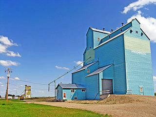
Arrowwood is a village in Vulcan County, Alberta, Canada. It is located on Highway 547, approximately 60 kilometres (37 mi) east of Okotoks.
Edgerton is a village in central Alberta, Canada. it is located 35 kilometres (22 mi) east of Wainwright.
Minburn is a hamlet in central, Alberta, Canada within the County of Minburn No. 27. It is located on the Yellowhead Highway and the Canadian National Railway, approximately 37 km (23 mi) west of the Town of Vermilion and 143 km (89 mi) east of the City of Edmonton.

Lethbridge County is a municipal district in southern Alberta, Canada. It is in Census Division No. 2 and part of the Lethbridge census agglomeration. It was known as the County of Lethbridge prior to December 4, 2013. Its name was changed in time for 2014 to coincide with its 50th anniversary.

Kneehill County is a municipal district in central Alberta, Canada within Census Division No. 5.

Beaver County is a municipal district in central-east Alberta, Canada. It is centred on Holden in the western part of Census Division No. 10. Its municipal office is located in Ryley.
Lacombe County is a municipal district in central Alberta, Canada. It is within in Census Division No. 8 north of the City of Red Deer. Its municipal office is 4 km (2.5 mi) west of Highway 2 and the City of Lacombe, and 6 km (3.7 mi) east of the Summer Village of Gull Lake, at the intersection of Highway 12 and Spruceville Road.

Woodlands County is a municipal district in north-central Alberta, Canada. Located in Census Division No. 13, its municipal office is located outside but adjacent to the Town of Whitecourt. A second municipal office is located in the Hamlet of Fort Assiniboine.

The County of Northern Lights is a municipal district in northwest Alberta, Canada. Located in Census Division 17, its municipal office is located in the Town of Manning.

The County of Wetaskiwin No. 10 is a municipal district in central Alberta, Canada that is south of Edmonton. Located in Census Division No. 11, its municipal office is in located in the City of Wetaskiwin.

The County of Two Hills No. 21 is a municipal district in east-central Alberta, Canada. Located in Census Division No. 10, its municipal office is located in the Town of Two Hills.

Smoky Lake County is a municipal district in north-eastern Alberta, Canada. Located in Census Division No. 12, its municipal office is located in the Town of Smoky Lake.
The Municipal District of Ranchland No. 66 is a municipal district (MD) in southwest Alberta, Canada. Containing no urban communities of any kind, its municipal office is located in Chain Lakes Provincial Park, approximately 38 km (24 mi) southwest of the Town of Nanton. Ranchland's rugged foothill terrain is unsuited for the crop agriculture practiced elsewhere in Alberta, and ranching remains the single livelihood of its inhabitants. With a 2016 population of 92, it is the least populated municipal district in Alberta, and its population density of 29 square kilometres for every resident is almost exactly equal to that of the Northwest Territories.

The County of Paintearth No. 18 is a municipal district in east central Alberta, Canada. Located in Census Division No. 7, its municipal office is located southeast of the Town of Castor near the intersection of Highway 12 and Highway 36.

Ranfurly is a hamlet in central Alberta, Canada within the County of Minburn No. 27. Previously an incorporated municipality, Ranfurly dissolved from village status on January 1, 1946 to become part of the Municipal District of Birch Lake No. 484.


