
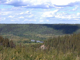
The Athabasca River is a river in Alberta, Canada, which originates at the Columbia Icefield in Jasper National Park and flows more than 1,231 km (765 mi) before emptying into Lake Athabasca. Much of the land along its banks is protected in national and provincial parks, and the river is designated a Canadian Heritage River for its historical and cultural importance. The scenic Athabasca Falls is located about 30 km (19 mi) upstream from Jasper.

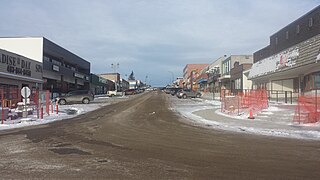
Fort McMurray is an urban service area in the Regional Municipality of Wood Buffalo in Alberta, Canada. It is located in northeast Alberta, in the middle of the Athabasca oil sands, surrounded by boreal forest. It has played a significant role in the development of the national petroleum industry. The 2016 Fort McMurray wildfire led to the evacuation of its residents and caused widespread damage.
The Regional Municipality of Wood Buffalo is a specialized municipality in northeast Alberta, Canada. It is the largest municipality in North America by area and is home to oil sand deposits known as the Athabasca oil sands.

Clearwater is a river of southern Alberta, Canada. Situated entirely in the Canadian Rockies and the Rocky Mountain foothills of Alberta, it is a glacier fed upper reach tributary of the North Saskatchewan River. The upper reach of the Clearwater has become popular for equestrian travellers due to the natural setting along the river.
The Clearwater River is located in the Canadian provinces of Saskatchewan and Alberta. It rises in the northern forest region of north-western Saskatchewan and joins the Athabasca River in north-eastern Alberta. It was part of an important trade route during the fur trade era and has been designated as a Canadian Heritage River.
Rocky Mountain House is a town in west-central Alberta, Canada. It is approximately 77 km (48 mi) west of Red Deer at the confluence of the Clearwater and North Saskatchewan Rivers, and at the crossroads of Highway 22 and Highway 11. The surrounding Clearwater County's administration office is located in Rocky Mountain House.

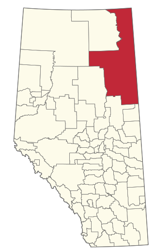
Division No. 16 is a census division in Alberta, Canada. It is located in the northeast portion of northern Alberta and surrounds the Urban Service Area of Fort McMurray.

Alberta Provincial Highway No. 63, commonly referred to as Highway 63, is a 434-kilometre (270 mi) highway in northern Alberta, Canada that connects the Athabasca oil sands and Fort McMurray to Edmonton via Highway 28. It begins as a two-lane road near the hamlet of Radway where it splits from Highway 28, running north through aspen parkland and farmland of north central Alberta. North of Boyle, it curves east to pass through the hamlet of Grassland and becomes divided west of Atmore where it again turns north, this time through heavy boreal forest and muskeg, particularly beyond Wandering River. Traffic levels significantly increase as Highway 63 bends through Fort McMurray, crossing the Athabasca River before connecting the city to the Syncrude and Suncor Energy plants further north. It ends approximately 16 km (10 mi) beyond a second crossing of the Athabasca River northeast of Fort McKay.
Winefred Lake is a large lake in east-northern Alberta, Canada. It is located in southern Wood Buffalo, in a remote area between Cold Lake and Fort McMurray, and has a total area of 122.8 km2 (47.4 sq mi). The closest community is the hamlet of Conklin, at 70 km (43 mi).
Fort McMurray First Nation is a Cree and Chipewyan band government located near Fort McMurray, Alberta. It is a member of the Athabasca Tribal Council and a Treaty 8 nation. The Athabasca Tribal Council represents 5 First Nation bands in northeast Alberta. Fort McMurray First Nation is governed by a Chief and two councillors.

The Fort McKay First Nation (FMFN) is a First Nations government in northeast Alberta comprising five Indian reserves – Fort McKay 174, Fort McKay 174C, Fort McKay 174D, Namur Lake 174B and Namur River 174A. The FMFN, signed to Treaty 8, is affiliated with the Athabasca Tribal Council and its members are of Cree, Metis and Dene heritage. The FMFN's traditional lands include portions of the Athabasca oil sands.
Conklin is a hamlet in northern Alberta, Canada within the Regional Municipality (RM) of Wood Buffalo. It is located on Highway 881 between Fort McMurray and Lac La Biche. It lies near the west end of Christina Lake at an elevation of 575 metres (1,886 ft), and was named for John Conklin, a railroad employee.
The Clearwater Formation is a stratigraphic unit of Early Cretaceous (Albian) age in the Western Canada Sedimentary Basin in northeastern Alberta, Canada. It was first defined by R.G. McConnell in 1893 and takes its name from the Clearwater River near Fort McMurray.
The McMurray Formation is a stratigraphic unit of Early Cretaceous age of the Western Canada Sedimentary Basin in northeastern Alberta. It takes the name from Fort McMurray and was first described from outcrops along the banks of the Athabasca River 5 kilometres (3.1 mi) north of Fort McMurray by F.H. McLearn in 1917. It is a well-studied example of fluvial to estuarine sedimentation, and it is economically important because it hosts most of the vast bitumen resources of the Athabasca Oil Sands region.
Alberta Provincial Highway No. 686, also known as Highway 686, is an east–west highway in northern Alberta, Canada. It has two sections; the main section is a gravel highway that spans approximately 90 kilometres (56 mi) from Highway 88 near Red Earth Creek to Trout Lake, and a two-kilometre-long (1.2 mi) developing freeway section in Fort McMurray which connects Highway 63 with the new neighbourhood of Parsons Creek known as Parsons Access Road.
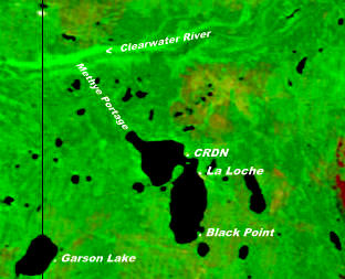
Garson Lake is a northern settlement in Saskatchewan on the eastern shore of Garson Lake. It is located near the Alberta border and can be accessed by Highway 956 off of Highway 155. A winter road connects it to Fort McMurray, Alberta in the winter months.
Christina Lake is an elongate lake in northern Alberta, Canada, located near Highway 881 east of Conklin, between Lac La Biche and Fort McMurray. Christina Lake and the Christina River are named to honour Christine Gordon, originally from Scotland, who was the first white woman to live permanently in the Fort McMurray area.
Gipsy-Gordon Wildland Park is a wildland provincial park in northern Alberta, Canada. The park was establisher on 20 December 2000 and is 35,766.3 hectares in size. The Government of Alberta announced its creation through its approval of the Lower Athabasca Regional Plan Land Use Framework in November 2000.

Fort McMurray-Lac La Biche is a current provincial electoral district in Alberta, Canada. The district will be one of 87 districts mandated to return a single member (MLA) to the Legislative Assembly of Alberta using the first past the post method of voting. It was contested for the first time in the 2019 Alberta election.
Whitemud Falls Wildland Provincial Park is a wildland provincial park in Wood Buffalo, northern Alberta, Canada. The park was established on 15 November 2000 and has an area of 3,842.55 hectares. The park is part of the Lower Athabasca Regional Plan.

