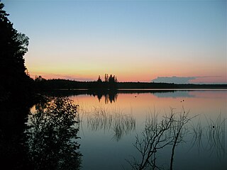
Lac La Biche is a hamlet in Alberta, Canada. The hamlet is the primary service centre for Lac La Biche County, Beaver Lake Cree Nation, Heart Lake First Nation, Kikino Metis Settlement, and Buffalo Lake Metis Settlement with a combined population of over 10,555 (2016) in the greater service area. It is located approximately 220 km (140 mi) northeast of the provincial capital of Edmonton. Previously incorporated as a town, Lac La Biche amalgamated with Lakeland County to form Lac La Biche County on August 1, 2007.

Alberta Provincial Highway No. 2, commonly referred to as Highway 2 or the Queen Elizabeth II Highway, is a major highway in Alberta, Canada that stretches from the Canada–United States border through Calgary and Edmonton to Grande Prairie. Running primarily north to south for approximately 1,273 kilometres (791 mi), it is the longest and busiest highway in the province carrying nearly 170,000 vehicles per day in central Calgary. Between Edmonton and Fort Macleod, the highway forms a portion of Alberta's Export Highway and the CANAMEX Corridor. More than half of Alberta's 4 million residents live in the Calgary–Edmonton Corridor created by Highway 2.

Alberta Provincial Highway No. 2A is the designation of six alternate routes off Highway 2 in Alberta, Canada. In general, these are original sections of Highway 2, such as the southern portion of Macleod Trail in Calgary. They passed through communities before limited-access freeways were built to shorten driving distance, accommodate heavier volumes and to bypass city traffic. Portions of the alignment of Highway 2A follow the route of the former Calgary and Edmonton Trail.

Alberta Provincial Highway No. 12, commonly referred to as Highway 12, is an east-west highway through central Alberta. It runs from Highway 22, through Lacombe and Stettler, to the Alberta-Saskatchewan border. It generally runs parallel to Highway 13 to the north. Highway 12 is about 364 kilometres (226 mi) long.

Highway 17 is a highway in Canada that straddles and criss-crosses the Alberta–Saskatchewan provincial border. The portion from the provincial border at Dillberry Lake Provincial Park to the provincial border 800 metres (2,600 ft) north of the North Saskatchewan River is designated as Alberta Provincial Highway No. 17 by Alberta Transportation, commonly referred to as Highway 17.

Alberta Provincial Highway No. 26, commonly referred to as Highway 26, is an east–west highway in central Alberta, Canada that connects Highway 13 in Camrose to Highway 14 near Kinsella. The route follows 12th Correction Line for its entire length, and does not pass through any communities east of Camrose.

Alberta Provincial Highway No. 36, commonly referred to as Highway 36 and officially named Veterans Memorial Highway, is a north-south highway in eastern Alberta, Canada that extends from Highway 4 near Warner to Highway 55 in Lac La Biche. Lac La Biche County is lobbying the Government of Alberta to renumber Highway 881 to Highway 36 from Lac La Biche north to Highway 63 south of Fort McMurray.

Alberta Provincial Highway No. 40, commonly referred to as Highway 40, is a south-north highway in western Alberta, Canada. It is also named Bighorn Highway and Kananaskis Trail in Kananaskis Country. Its segmented sections extend from Coleman in the Municipality of Crowsnest Pass northward to the City of Grande Prairie and is currently divided into four sections.

Alberta Provincial Highway No. 63, commonly referred to as Highway 63, is a 434-kilometre (270 mi) highway in northern Alberta, Canada that connects the Athabasca oil sands and Fort McMurray to Edmonton via Highway 28. It begins as a two-lane road near the hamlet of Radway where it splits from Highway 28, running north through aspen parkland and farmland of north central Alberta. North of Boyle, it curves east to pass through the hamlet of Grassland and becomes divided west of Atmore where it again turns north, this time through heavy boreal forest and muskeg, particularly beyond Wandering River. Traffic levels significantly increase as Highway 63 bends through Fort McMurray, crossing the Athabasca River before connecting the city to the Syncrude and Suncor Energy plants further north. It ends approximately 16 km (10 mi) beyond a second crossing of the Athabasca River northeast of Fort McKay.

Lakeland Provincial Park and Lakeland Provincial Recreation Area are located east of Lac La Biche, Alberta, Canada, in Lac La Biche County.

Lac La Biche County is a specialized municipality within Division No. 12 in northern Alberta, Canada. Its economy is based on the oil and gas industry, agriculture and tourism. Some sawmills are also present.

Alberta Provincial Highway No. 55, commonly referred to as Highway 55, is a 263-kilometre (163 mi) long east–west highway in northeast Alberta, Canada. It extends from the Saskatchewan border in the east through the Cold Lake, Lac La Biche, and Athabasca where it ends at Highway 2. In Saskatchewan, it continues as Saskatchewan Highway 55.

Alberta Provincial Highway No. 16A, commonly referred to as Highway 16A, is the designation of three alternate routes off Alberta Highway 16 in Alberta, Canada. The Evansburg – Entwistle section is called 16A:08 by Alberta Transportation, while 16A:24 runs through Vegreville. The section west of Edmonton is labelled 16A:14 and 16A:16 on Alberta Transportation maps, but is better known as Parkland Highway and Stony Plain Road.

The Northern Woods and Water Route is a 2,400-kilometre (1,500 mi) route through northern British Columbia, Alberta, Saskatchewan and Manitoba in Western Canada. As early as the 1950s community groups came together to establish a northern travel route; this was proposed as the Northern Yellowhead Transportation Route. The Northern Woods and Water Route Association was established in 1974, and encouraged promotion of the route with the promise of an increase in tourist travel. The route was designated in 1974 and is well signed throughout the connector highways. The route starts at Dawson Creek at the British Columbia Spirit River Highway 49 and ends at Winnipeg, Manitoba, running through the northern region of the western provinces. The Northern Woods and Water Route (NWWR) includes connector routes from west to east including British Columbia Highway 49, Alberta Highway 49, AB Hwy 2A, AB Hwy 2, AB Hwy 55, Saskatchewan Highway 55, SK Hwy 9, Manitoba Provincial Road 283, Manitoba Highway 10, MB PTH 5, MB PTH 68, MB PTH 6. The halfway point of the NWWR is approximately at Goodsoil, Saskatchewan.

Beaver River is a large river in east-central Alberta and central Saskatchewan, Canada. It flows east through Alberta and Saskatchewan and then turns sharply north to flow into Lac Île-à-la-Crosse on the Churchill River which flows into Hudson Bay. The Alberta part is in the Cold Lake oil sands.

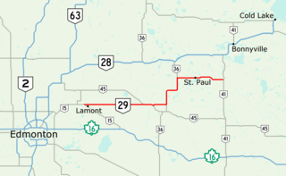
Alberta Provincial Highway No. 29, commonly referred to as Highway 29, is a 153-kilometre (95 mi) highway in east–central Alberta, Canada that connects Highway 15 near Lamont to Highway 41 north of Elk Point. It runs mostly west to east across aspen parkland through Hairy Hill, turning north through Duvernay, Brosseau, Foisy, St. Brides, and east to St. Paul before ending at Highway 41 approximately 9 km (5.6 mi) north of Elk Point, concurrent with Highways 36 and 45 for lengthy sections.

Alberta Provincial Highway No. 881, commonly referred to as Highway 881, is a highway split into two sections in northeast Alberta, Canada. Each section is over 200 kilometres (120 mi) in length; the southern portion runs from Highway 13 in Hardisty to Highway 55 northwest of Bonnyville, while the northern section stretches from Highway 55 in Lac La Biche to the south side of Fort McMurray, serving as an important alternate route to Highway 63. A 72-kilometre (45 mi) section of Highway 55 joins the two sections. Lac La Biche County is lobbying the Government of Alberta to renumber the section of Highway 881 between Lac La Biche and Fort McMurray to Highway 36.

Alberta Provincial Highway No. 628, commonly referred to as Highway 628, is a highway in the province of Alberta, Canada that runs west to east through the Edmonton Capital Region in two sections. The western 19-kilometre-long (12 mi) section runs from the town of Stony Plain to the Edmonton city limits at 231 Street. The eastern 6-kilometre-long (4 mi) section, also known as a Whitemud Extension, runs from Anthony Henday Drive to Highway 21 just south of Sherwood Park. It continues further past Half Moon Lake to Wye Road (Highway 630) near North Cooking Lake.

Alberta Provincial Highway No. 633, commonly referred to as Highway 633, is a highway in the province of Alberta, Canada. It runs west-east from Highway 757 just north of Highway 16 to Highway 2 in St. Albert. It runs through the summer villages on the north side of Isle Lake, and the south side of Lac Ste. Anne. It is also known as Villeneuve Road between Villeneuve and St. Albert.
Alberta Provincial Highway No. 46, commonly referred to as Highway 46, was a highway in north-central Alberta, Canada connecting Edmonton to Lac La Biche. It existed between the 1950s and 1970s, and has formed portions of Highways 55 and 63 since the late 1970s.


