
Alberta Provincial Highway No. 2, commonly referred to as Highway 2 or the Queen Elizabeth II Highway, is a major highway in Alberta, Canada that stretches from the Canada–United States border through Calgary and Edmonton to Grande Prairie. Running primarily north to south for approximately 1,273 kilometres (791 mi), it is the longest and busiest highway in the province carrying nearly 170,000 vehicles per day in central Calgary. Between Edmonton and Fort Macleod, the highway forms a portion of Alberta's Export Highway and the CANAMEX Corridor. More than half of Alberta's 4 million residents live in the Calgary–Edmonton Corridor created by Highway 2.

Alberta Provincial Highway No. 1A is the designation of two alternate routes off the Alberta portion of the Trans-Canada Highway. However, it is not the only name used for spurs off Highway 1 - Highway 1X is another such designation. These highways, however, are not part of the Trans-Canada Highway network, and only have Alberta's provincial primary highway shields instead of the ones used for the Trans-Canada Highway.
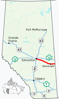
Alberta Provincial Highway No. 14, commonly referred to as Highway 14, is an east-west highway in central Alberta, Canada. It stretches from Edmonton through Wainwright to the Alberta–Saskatchewan border, running parallel to the more northern Highway 16. Highway 14 is about 257 kilometres (160 mi) long.

Alberta Provincial Highway No. 13, commonly referred to as Highway 13, is an east–west highway through central Alberta. It spans from Alder Flats, 7 km (4 mi) west of Highway 22, to the Alberta-Saskatchewan border. Highway 13 is about 366 kilometres (227 mi) long. East of the City of Wetaskiwin, it generally parallels a Canadian Pacific rail line.

Alberta Provincial Highway No. 12, commonly referred to as Highway 12, is an east-west highway through central Alberta. It runs from Highway 22, through Lacombe and Stettler, to the Alberta-Saskatchewan border. It generally runs parallel to Highway 13 to the north. Highway 12 is about 364 kilometres (226 mi) long.
Alberta Provincial Highway No. 6, commonly referred to as Highway 6, is a north-south highway in southern Alberta, Canada. It spans approximately 74 kilometres (46 mi) from Alberta's border with Montana to Highway 3.

Highway 17 is a highway in Canada that straddles and criss-crosses the Alberta–Saskatchewan provincial border. The portion from the provincial border at Dillberry Lake Provincial Park to the provincial border 800 metres (2,600 ft) north of the North Saskatchewan River is designated as Alberta Provincial Highway No. 17 by Alberta Transportation, commonly referred to as Highway 17.

Alberta Provincial Highway No. 20, commonly referred to as Highway 20, is a highway in central Alberta, Canada, west of Highway 2.

Alberta Provincial Highway No. 24, commonly referred to as Highway 24, is a highway in southern Alberta, Canada, east of Calgary.

Alberta Provincial Highway No. 36, commonly referred to as Highway 36 and officially named Veterans Memorial Highway, is a north-south highway in eastern Alberta, Canada that extends from Highway 4 near Warner to Highway 55 in Lac La Biche. Lac La Biche County is lobbying the Government of Alberta to renumber Highway 881 to Highway 36 from Lac La Biche north to Highway 63 south of Fort McMurray.

Alberta Provincial Highway No. 40, commonly referred to as Highway 40, is a south-north highway in western Alberta, Canada. It is also named Bighorn Highway and Kananaskis Trail in Kananaskis Country. Its segmented sections extend from Coleman in the Municipality of Crowsnest Pass northward to the City of Grande Prairie and is currently divided into four sections.

Alberta Provincial Highway No. 41, commonly referred to as Highway 41 and officially named Buffalo Trail, is a 686-kilometre (426 mi) north-south highway in eastern Alberta, Canada. It extends from the United States border at Wild Horse to Highway 55 in the hamlet of La Corey north of Bonnyville.

Alberta Provincial Highway No. 52, commonly referred to as Highway 52, is an east–west highway in southern Alberta, Canada, south of Lethbridge that connects Highway 4 to Highway 5 via Raymond.

Alberta Provincial Highway No. 66, commonly referred to as Highway 66, is an east–west highway in central Alberta, Canada. In the east, Highway 66 begins at an intersection with Highways 22 and 762 south of the Hamlet of Bragg Creek and ends 28 km (17 mi) to the west at the Little Elbow Recreation Area. The highway provides access to the Easter Seals Camp Horizon and Elbow Falls.

Alberta Provincial Highway No. 814, commonly referred to as Highway 814, is a highway in the province of Alberta, Canada. It runs south-north from Highway 13 in Wetaskiwin to Beaumont town limits at Highway 625. This highway used to extend to Edmonton limits, until the Beaumont government took control of the road. This extension is the most direct link between Edmonton and the suburb of Beaumont. This route is also known as 47 Street in Wetaskiwin, and 50 Street in Beaumont and Edmonton.

Alberta Provincial Highway No. 566 in the Canadian province of Alberta lies approximately halfway between Calgary and Airdrie, running west to east from Highway 772 to Highway 9 near the hamlets of Kathyrn and Keoma.

Alberta Provincial Highway No. 560, commonly referred to as Highway 560 or Glenmore Trail, is a highway in the province of Alberta, Canada. It runs west–east from the east Calgary boundary at 84 Street SE, north along the city boundary to Range Road 284, across Highway 791 south of Chestermere to the southern terminus of the northern section of Highway 797, Centre Street in Langdon.

Symons Valley Road is a major arterial road and rural highway that links Calgary from Stoney Trail to Madden in Alberta, Canada. It is preceded by Beddington Trail, a major expressway along West Nose Creek linking Deerfoot Trail to Stoney Trail within Calgary, and is succeeded by Range Road 30. The portion of Symons Valley Road within Rocky View County from the Calgary city limit to Highway 574 south of Madden is designated as Alberta Provincial Highway No. 772.
Alberta Provincial Highway No. 16X, commonly referred to as Highway 16X, is the designation of one former and three proposed routes off Highway 16 in Alberta, Canada. The former section was a 36 km (22 mi) east–west provincial highway in Edmonton Capital Region, that existed for approximately 20 years between the 1970s and 1997 and is now part of Highway 16. Right of way is set aside around Hinton, Edson, and Lloydminster that is presently designated as Highway 16X.


