
The Trans-Canada Highway is a transcontinental federal-provincial highway system that travels through all ten provinces of Canada from the Pacific Ocean on the west to the Atlantic on the east. The main route spans 7,821 km (4,860 mi) across the country, one of the longest routes of its type in the world. The highway system is recognizable by its distinctive white-on-green maple leaf route markers, although there are small variations in the markers in some provinces.

The Crowsnest Highway is an east-west highway in British Columbia and Alberta, Canada. It stretches 1,161 km (721 mi) across the southern portions of both provinces, from Hope, British Columbia to Medicine Hat, Alberta, providing the shortest highway connection between the Lower Mainland and southeast Alberta through the Canadian Rockies. The mostly two-lane highway was officially designated in 1932, mainly following a mid-19th-century gold rush trail originally traced out by an engineer named Edgar Dewdney. It takes its name from the Crowsnest Pass, the location at which the highway crosses the Continental Divide between British Columbia and Alberta.

Alberta Provincial Highway No. 2, commonly referred to as Highway 2 or the Queen Elizabeth II Highway, is a major highway in Alberta that stretches from the Canada–United States border through Calgary and Edmonton to Grande Prairie. Running primarily north to south for approximately 1,273 kilometres (791 mi), it is the longest and busiest highway in the province carrying more than 170,000 vehicles per day near Downtown Calgary. The Fort Macleod—Edmonton section forms a portion of the CANAMEX Corridor that links Alaska to Mexico. More than half of Alberta's 4 million residents live in the Calgary–Edmonton Corridor created by Highway 2.

Alberta Provincial Highway No. 2A is the designation of six alternate routes off Highway 2 in Alberta, Canada. In general, these are original sections of Highway 2, such as the southern portion of Macleod Trail in Calgary. They passed through communities before limited-access freeways were built to shorten driving distance, accommodate heavier volumes and to bypass city traffic. Portions of the alignment of Highway 2A follow the route of the former Calgary and Edmonton Trail.

Alberta Provincial Highway No. 3, commonly referred to as Highway 3 and officially named the Crowsnest Highway, is a 324-kilometre (201 mi) highway that traverses southern Alberta, Canada, running from the Crowsnest Pass through Lethbridge to the Trans-Canada Highway in Medicine Hat. Together with British Columbia Highway 3 which begins in Hope, it forms an interprovincial route that serves as an alternate to the Trans-Canada from the Lower Mainland to the Canadian Prairies.
Alberta Provincial Highway No. 1, commonly referred to as Highway 1, is a major east–west highway in Southern Alberta that forms the southern mainline of the Trans-Canada Highway. It runs from the British Columbia border near Lake Louise through Calgary to the Saskatchewan border east of Medicine Hat. It continues as Highway 1 into both provinces. It spans approximately 534 km (332 mi) from Alberta's border with British Columbia in the west to its border with Saskatchewan in the east. The route is a divided expressway throughout the province with the exception of a section in central Calgary where it is an arterial thoroughfare. Twinning of the final 8.5 km (5.3 mi) of Highway 1 between Lake Louise and the British Columbia border was completed by Parks Canada and opened to traffic on June 12, 2014.

Alberta Provincial Highway No. 1A is the designation of two alternate routes off the Alberta portion of Trans-Canada Highway 1. However, it is not the only name used for spurs off Highway 1 - Highway 1X is another such designation. Despite these highways being suffixed routes of Highway 1, they are not part of the Trans-Canada Highway network, and are signed with Alberta's provincial primary highway shields instead of the Trans-Canada shields used for Highway 1.
Provincial Trunk Highway 1 is Manitoba's section of the Trans-Canada Highway. It is a heavily used, 4-lane divided highway, with the exception of a short 18 km section in the southeastern corner of the province. It is the main link between southern Manitoba's largest cities, and also serves as the province's main transportation link to the neighbouring provinces of Saskatchewan and Ontario. The highway is the only major east-west divided highway in Manitoba, and carries a large majority of east-west traffic within and through the province. It has full freeway status sections at Portage la Prairie and Winnipeg. The total distance of the Trans-Canada Highway in Manitoba is approximately 490 km (300 mi).
Provincial Trunk Highway 75 is a major highway in the province of Manitoba, Canada. It is the main link between the city of Winnipeg and the Canada–United States border, where it connects with Interstate 29 (I-29)/U.S. Route 81.

Alberta Provincial Highway No. 8, commonly referred to as Highway 8, is a highway in Southern Alberta that connects Highway 22 in Rocky View County just north of Redwood Meadows to Deerfoot Trail (Highway 2) in Calgary. In Rocky View County, the highway initially parallels the Elbow River before entering Calgary where it becomes a heavily travelled expressway known as Glenmore Trail, named after the reservoir which it crosses. Glenmore Trail is a freeway between Sarcee Trail in southwest Calgary to Ogden Road in the southeast, carrying nearly 160,000 vehicles per weekday at its busiest point placing it second only to Deerfoot Trail as the busiest road in Western Canada. It will be part of Stoney Trail once construction of the West Calgary Ring Road is completed. East of Deerfoot Trail, Glenmore Trail continues east linking to Stoney Trail, and it becomes Highway 560 en route to Langdon.

Alberta Provincial Highway No. 4, commonly referred to as Highway 4, is a 103-kilometre (64 mi) highway in southern Alberta, Canada that connects Highway 3 in Lethbridge to Interstate 15 in Montana. The highway was designated in 1999 as the First Special Service Force Memorial Highway in honour of elite soldiers who travelled to Helena, Montana for training before World War II. The highway continues on into America retaining that designation.

Alberta Provincial Highway No. 21, commonly referred to as Highway 21, is a north-south highway in Alberta, Canada that parallels Highway 2 between Calgary and Edmonton. It is approximately 328 kilometres (204 mi) in length. It begins at the Trans-Canada Highway (Highway 1) east of Strathmore, and ends at Fort Saskatchewan where it is succeeded by Highway 15. The northernmost 25 kilometres (16 mi) of the highway are twinned. Highway 21 runs roughly parallel to the main north-south CN rail line between Calgary and Edmonton between Three Hills and Looma.

Alberta Provincial Highway No. 10, commonly referred to as Highway 10, is a 22 km (14 mi) highway in southern Alberta, Canada that forms a part of Hoo Doo Trail. It is located wholly within the Town of Drumheller as a result of the former City of Drumheller's amalgamation with the Municipal District of Badlands No. 7 on January 1, 1998. It begins at Highway 9 in the heart of Drumheller and extends southeast along the Red Deer River where it passes through Rosedale, then crosses Highway 56 and travels through East Coulee. It ends by splitting off into Highways 570, 564, and 569.

Highway 19 and Highway 625 are two provincial highways south of Edmonton in the Canadian province of Alberta that form a continuous east–west route connecting Highway 60 near Devon to Highway 21 east of Beaumont. Highway 19 was acquired by the City of Edmonton in the land annexation approved by the Province in 2019. Highway 19 passes north of the Edmonton International Airport and, in tandem with Highway 60, provides a southwest bypass of Edmonton between Highways 2 and 16. East of Highway 2, Highway 19 becomes Highway 625 and continues through Nisku Industrial Park. It intersects Highway 814 in before ending at Highway 21.

Alberta Provincial Highway No. 23, commonly referred to as Highway 23, is a highway in southern Alberta, Canada, east of Highway 2 that serves as an alternate route between Calgary and Lethbridge.
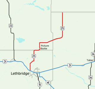
Alberta Provincial Highway No. 25, commonly referred to as Highway 25, is a highway in southern Alberta, Canada, north of Lethbridge.
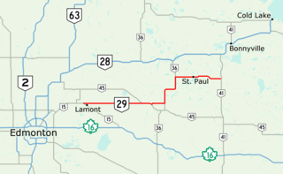
Alberta Provincial Highway No. 29, commonly referred to as Highway 29, is a 153-kilometre (95 mi) highway in east–central Alberta, Canada that connects Highway 15 near Lamont to Highway 41 north of Elk Point. It runs mostly west to east across aspen parkland through Hairy Hill, turning north through Duvernay, Brosseau, Foisy, St. Brides, and east to St. Paul before ending at Highway 41 approximately 9 km (5.6 mi) north of Elk Point, concurrent with Highways 36 and 45 for lengthy sections.

Alberta Provincial Highway No. 3A, commonly referred to as Highway 3A, is the designation of four alternate routes of Highway 3 in southern Alberta, Canada. All four segments are former alignments of Highway 3, also known as the Crowsnest Highway.

The Red Coat Trail is a 1,300-kilometre (810 mi) route that approximates the path taken in 1874 by the North-West Mounted Police in their quest to bring law and order to the Canadian West.

Groat Road is a freeway in Edmonton, Alberta. It is named after Maclom Groat, a former Hudson’s Bay Company employee who settled in the present-day Groat Estates area in the 1880s. Groat Road is part of a 40-kilometre-long (25 mi) continuous roadway that runs through Sherwood Park, Edmonton, and St. Albert that includes Wye Road, Sherwood Park Freeway, Whyte Avenue, portions of University Avenue and Saskatchewan Drive, and St. Albert Trail. Groat Road functions as a grade-separated parkway between 87 Avenue and 111 Avenue.

