Alberta Provincial Highway No. 22, commonly referred to as Highway 22 and officially named Cowboy Trail, is a 584-kilometre (363 mi) highway in the Canadian province of Alberta. It generally parallels Highway 2, beginning in the foothills of southern Alberta at Highway 3 near Lundbreck Falls. It proceeds north along the eastern slopes of the Rocky Mountains passing through the foothills and ranch country to the aspen parkland of northern Alberta, ending at Highway 18 near Mayerthorpe.

Alberta Provincial Highway No. 1A is the designation of two alternate routes off the Alberta portion of Trans-Canada Highway 1. However, it is not the only name used for spurs off Highway 1 - Highway 1X is another such designation. Despite these highways being suffixed routes of Highway 1, they are not part of the Trans-Canada Highway network, and are signed with Alberta's provincial primary highway shields instead of the Trans-Canada shields used for Highway 1.

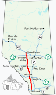
Alberta Provincial Highway No. 21, commonly referred to as Highway 21, is a north-south highway in Alberta, Canada that parallels Highway 2 between Calgary and Edmonton. It is approximately 328 kilometres (204 mi) in length. It begins at the Trans-Canada Highway (Highway 1) east of Strathmore, and ends at Fort Saskatchewan where it is succeeded by Highway 15. The northernmost 25 kilometres (16 mi) of the highway are twinned. Highway 21 runs roughly parallel to the main north-south CN rail line between Calgary and Edmonton between Three Hills and Looma.

Alberta Provincial Highway No. 12, commonly referred to as Highway 12, is an east-west highway through central Alberta. It runs from Highway 22, through Lacombe and Stettler, to the Alberta-Saskatchewan border. It generally runs parallel to Highway 13 to the north. Highway 12 is about 364 kilometres (226 mi) long.

Alberta Provincial Highway No. 9, commonly referred to as Highway 9, is a highway in south-central Alberta, Canada, which together with Saskatchewan Highway 7 connects Calgary to Saskatoon, Saskatchewan via Drumheller. It is designated as a core route of the National Highway System, forming a portion of an interprovincial corridor. Highway 9 spans approximately 324 km (201 mi) from the Trans-Canada Highway east of Calgary to Alberta's border with Saskatchewan.

Highway 17 is a highway in Canada that straddles and criss-crosses the Alberta–Saskatchewan provincial border. The portion from the provincial border at Dillberry Lake Provincial Park to the provincial border 800 metres (2,600 ft) north of the North Saskatchewan River is designated as Alberta Provincial Highway No. 17 by Alberta Transportation, commonly referred to as Highway 17.

Alberta Provincial Highway No. 11A is the designation of two routes that connect to Highway 11 in Alberta, Canada. The Rocky Mountain House section is referred to as 11A:02 by Alberta Transportation, while 11A:06 runs from Sylvan Lake to Red Deer.

Highway 19 and Highway 625 are two provincial highways south of Edmonton in the Canadian province of Alberta that form a continuous east–west route connecting Highway 60 near Devon to Highway 21 east of Beaumont. Highway 19 was acquired by the City of Edmonton in the land annexation approved by the Province in 2019. Highway 19 passes north of the Edmonton International Airport and, in tandem with Highway 60, provides a southwest bypass of Edmonton between Highways 2 and 16. East of Highway 2, Highway 19 becomes Highway 625 and continues through Nisku Industrial Park. It intersects Highway 814 in before ending at Highway 21.

Alberta Provincial Highway No. 20, commonly referred to as Highway 20, is a highway in central Alberta, Canada, west of Highway 2.

Alberta Provincial Highway No. 28, commonly referred to as Highway 28, is a highway in north-central Alberta, Canada that connects Edmonton to Cold Lake. It begins at Yellowhead Trail (Highway 16) in Edmonton as 97 Street NW, running through the city's north suburbs before entering Sturgeon County and passing CFB Edmonton. After merging with Highway 28A near Gibbons it winds through agricultural lands of north-central Alberta, roughly paralleling the North Saskatchewan River until Smoky Lake before continuing east through St. Paul County to Bonnyville. It turns northeast to CFB Cold Lake, before ending at Lakeshore Drive in the city of Cold Lake shortly thereafter.

Alberta Provincial Highway No. 40, commonly referred to as Highway 40, is a south-north highway in western Alberta, Canada. It is also named Bighorn Highway and Kananaskis Trail in Kananaskis Country. Its segmented sections extend from Coleman in the Municipality of Crowsnest Pass northward to the City of Grande Prairie and is currently divided into four sections.

Alberta Provincial Highway No. 55, commonly referred to as Highway 55, is a 263-kilometre (163 mi) long east–west highway in northeast Alberta, Canada. It extends from the Saskatchewan border in the east through the Cold Lake, Lac La Biche, and Athabasca where it ends at Highway 2. In Saskatchewan, it continues as Saskatchewan Highway 55.

Alberta Provincial Highway No. 16A, commonly referred to as Highway 16A, is the designation of three alternate routes off Alberta Highway 16 in Alberta, Canada. The Evansburg – Entwistle section is called 16A:08 by Alberta Transportation, while 16A:24 runs through Vegreville. The section west of Edmonton is labelled 16A:14 and 16A:16 on Alberta Transportation maps, but is better known as Parkland Highway and Stony Plain Road.
Highway 21 is a highway in the Canadian province of Saskatchewan. It runs from Montana Secondary Highway 233 at the United States border near Willow Creek to Highway 950/Highway 919 within the Meadow Lake Provincial Park. Highway 21 is about 715 km (444 mi) long.

Alberta Provincial Highway No. 628, commonly referred to as Highway 628, is a highway in the province of Alberta, Canada that runs west to east through the Edmonton Capital Region in two sections. The western 19-kilometre-long (12 mi) section runs from the town of Stony Plain to the Edmonton city limits at 231 Street. The eastern 6-kilometre-long (4 mi) section, also known as a Whitemud Extension, runs from Anthony Henday Drive to Highway 21 just south of Sherwood Park.

Alberta Provincial Highway No. 633, commonly referred to as Highway 633, is a highway in the province of Alberta, Canada. It runs west-east from Highway 757 just north of Highway 16 to Highway 2 in St. Albert. It runs through the summer villages on the north side of Isle Lake, and the south side of Lac Ste. Anne. It is also known as Villeneuve Road between Villeneuve and St. Albert.

Alberta Provincial Highway No. 855 is a highway in the province of Alberta, Canada. It runs south-north from Highway 9 west of Hanna to Highway 55 and Highway 63 in Atmore. It provides access to rural areas, and is gravel at both its south and north ends. At 389 km (242 mi) it is the longest 500-986 series highway in Alberta.
Alberta Provincial Highway No. 873, commonly referred to as Highway 873, is a highway in southern Alberta, Canada. It generally runs north-south from Range Road 162 near the Hamlet of Rainier, through the City of Brooks to Highway 550 in Village of Duchess.
Alberta Provincial Highway No. 46, commonly referred to as Highway 46, was a highway in north-central Alberta, Canada connecting Edmonton to Lac La Biche. It existed between the 1950s and 1970s, and has formed portions of Highways 55 and 63 since the late 1970s.

