This page is based on this
Wikipedia article Text is available under the
CC BY-SA 4.0 license; additional terms may apply.
Images, videos and audio are available under their respective licenses.

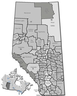
Division No. 10 is a census division in Alberta, Canada. It is located in the east-central portion of central Alberta and includes Alberta's portion of the City of Lloydminster.

Marwayne is a village in central Alberta, Canada. It is located 44 kilometres (27 mi) north-west of the city of Lloydminster and 21 kilometres (13 mi) west of the Saskatchewan border.

Dunmore is a hamlet in Alberta, Canada within Cypress County, located 2.6 kilometres (1.6 mi) southeast of Medicine Hat's city limits on Highway 1 and the Canadian Pacific Railway mainline. A portion of the hamlet is recognized as a designated place by Statistics Canada.

Frog Lake is a Cree community approximately 207 km (129 mi) east of Edmonton, Alberta, Canada. It is located 11 km (6.8 mi) northeast of the Hamlet of Heinsburg and 13 km (8.1 mi) southwest of the Fishing Lake Metis Settlement.

Schuler is a hamlet in southern Alberta, Canada within Cypress County, located 4 kilometres (2.5 mi) east of Highway 41, approximately 40 kilometres (25 mi) northeast of Medicine Hat.

Mielno is a village in the administrative district of Gmina Grunwald, within Ostróda County, Warmian-Masurian Voivodeship, in northern Poland. It lies approximately 26 kilometres (16 mi) south-east of Ostróda and 37 km (23 mi) south-west of the regional capital Olsztyn.

Blackfoot is a hamlet in east-central Alberta, Canada, within the County of Vermilion River. It is located 1 kilometre (0.62 mi) north of Highway 16, approximately 10 kilometres (6.2 mi) west of Lloydminster.

Cadogan is a hamlet in central Alberta, Canada within the Municipal District of Provost No. 52. Previously an incorporated municipality, Cadogan dissolved from village status on January 1, 1946 to become part of the Municipal District of Hillcrest No. 362.

Clandonald is a hamlet in central Alberta, Canada within the County of Vermilion River. It is located approximately 28 kilometres (17 mi) north of Highway 16 and 58 kilometres (36 mi) northwest of Lloydminster.

Eaglesham is a hamlet in northern Alberta, Canada within Birch Hills County, located 6 kilometres (3.7 mi) north of Highway 49, approximately 89 kilometres (55 mi) northeast of Grande Prairie.

Heinsburg is a hamlet in central Alberta, Canada within the County of St. Paul No. 19. It is located approximately 21 kilometres (13 mi) north of Highway 45 and 66 kilometres (41 mi) northwest of Lloydminster.

Islay is a hamlet in central Alberta, Canada, within the County of Vermilion River. Previously an incorporated municipality, Islay dissolved from village status on March 15, 1944, to become part of the Municipal District of Vermilion Valley No. 482. The community was named after Islay, in Scotland, the ancestral home of pioneer settlers.

Lindbergh is a hamlet in central Alberta, Canada within the County of St. Paul No. 19. It is located approximately 17 kilometres (11 mi) east of Highway 41 and 77 kilometres (48 mi) northwest of Lloydminster.

McLaughlin is a hamlet in central Alberta, Canada within the County of Vermilion River. It is 9 km (5.6 mi) west of Highway 17, approximately 33 km (21 mi) southwest of Lloydminster.

Rivercourse is a hamlet in Eastern Alberta, Canada within the County of Vermilion River. It is located 3 kilometres (1.9 mi) west of Highway 17, approximately 26 kilometres (16 mi) south of Lloydminster.

Riverview is a hamlet in central Alberta, Canada within the County of St. Paul No. 19. It is located approximately 18 kilometres (11 mi) east of Highway 41 and 76 kilometres (47 mi) northwest of Lloydminster.

Saddle Lake is a settlement in central Alberta. It is located on Saddle Lake Indian Reserve 125 and is governed by the Saddle Lake Cree Nation.

Streamstown is a hamlet in central Alberta, Canada within the County of Vermilion River. It is located approximately 11 kilometres (6.8 mi) west of Highway 17 and 19 kilometres (12 mi) northwest of Lloydminster.

Tulliby Lake is a hamlet in central Alberta, Canada within the County of Vermilion River. It is located approximately 23 kilometres (14 mi) north of Highway 45 and 50 kilometres (31 mi) northwest of Lloydminster.

Violet Grove is a hamlet in central Alberta, Canada within Brazeau County. It is located 7 km (4.3 mi) southwest of Drayton Valley on Highway 620, approximately 110 km (68 mi) southwest of Edmonton.


