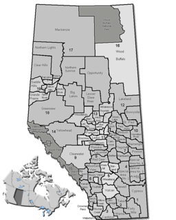
Division No. 16 is a census division in Alberta, Canada. It is located in the northeast portion of northern Alberta and surrounds the Urban Service Area of Fort McMurray.

Beauvallon is a hamlet in central Alberta, Canada within the County of Two Hills No. 21. It is located on Highway 45, approximately 139 kilometres (86 mi) east of Edmonton.

Boyne Lake is an unincorporated community in northern Alberta in the County of St. Paul No. 19, located 11 kilometres (6.8 mi) north of Highway 36, 142 kilometres (88 mi) northeast of Edmonton.

Duvernay is a hamlet in central Alberta, Canada within the County of Two Hills No. 21. It is located 1.6 km (1.0 mi) north of the intersection of Highway 36 and Highway 29 along the south bank of the North Saskatchewan River, approximately 53 km (33 mi) southwest of St. Paul. The hamlet of Brosseau is located immediately across the river along the north bank.

Fork Lake is an unincorporated community in northern Alberta, Canada. It is located in Lac La Biche County, 6 kilometres (3.7 mi) south of Highway 55 and 93 kilometres (58 mi) west of Cold Lake.

Hairy Hill is a hamlet in Alberta, Canada within the County of Two Hills No. 21. It is located on Highway 45, approximately 102 kilometres (63 mi) east of Edmonton.

Lafond is a hamlet in northern Alberta, Canada within the County of St. Paul No. 19. It is located 5 kilometres (3.1 mi) east of Highway 36, approximately 117 kilometres (73 mi) northwest of Lloydminster.

Lavoy is a hamlet in central Alberta, Canada within the County of Minburn No. 27. It is located on Highway 16, approximately 108 kilometres (67 mi) east of Edmonton.

Lottie Lake is a hamlet in northern Alberta, Canada within the County of St. Paul No. 19. It is located 1 kilometre (0.62 mi) west of Highway 36, approximately 138 kilometres (86 mi) northeast of Edmonton.

Morecambe is a hamlet in central Alberta, Canada within the County of Two Hills No. 21. It is located 0.5 kilometres (0.31 mi) south of Highway 45, approximately 104 kilometres (65 mi) northwest of Lloydminster.

Musidora is a hamlet in central Alberta, Canada within the County of Two Hills No. 21. It is located on Highway 45, approximately 112 kilometres (70 mi) northwest of Lloydminster.

Ranfurly is a hamlet in central Alberta, Canada within the County of Minburn No. 27. Previously an incorporated municipality, Ranfurly dissolved from village status on January 1, 1946 to become part of the Municipal District of Birch Lake No. 484.

Spedden is a hamlet in central Alberta, Canada within Smoky Lake County. It is located 0.3 kilometres (0.19 mi) north of Highway 36, approximately 106 kilometres (66 mi) southwest of Cold Lake. It was named after one of the original surveyors who died in the area in 1919. Previously it was Cache Lake.

St. Edouard is a hamlet in northern Alberta, Canada within the County of St. Paul No. 19. It is located 2 kilometres (1.2 mi) south of Highway 28, approximately 82 kilometres (51 mi) southwest of Cold Lake.

St. Lina or Ste-Lina in French, is a hamlet in northern Alberta, Canada within the County of St. Paul No. 19. It is home of St. Lina Community Hall. It is located approximately 14 kilometres (8.7 mi) north of Highway 28 and 85 kilometres (53 mi) southwest of Cold Lake.

St. Vincent is a hamlet in northern Alberta, Canada within the County of St. Paul No. 19. It is located 3 kilometres (1.9 mi) south of Highway 28, approximately 79 kilometres (49 mi) southwest of Cold Lake.

Sunnynook is a hamlet in southern Alberta, Canada within Special Area No. 2. It is located approximately 10 kilometres (6.2 mi) east of Highway 36 and 86 kilometres (53 mi) northeast of Brooks. The hamlet formerly housed the Berry Creek Community School Division office and area post office until amalgamation of the school division into Prairie Land Regional Division.

Therien is a hamlet in central Alberta, Canada within the Municipal District of Bonnyville No. 87, located approximately 7 kilometres (4.3 mi) north of Highway 28 and 74 kilometres (46 mi) southwest of Cold Lake.

Tulliby Lake is a hamlet in central Alberta, Canada within the County of Vermilion River. It is located approximately 23 kilometres (14 mi) north of Highway 45 and 50 kilometres (31 mi) northwest of Lloydminster.

Lake Newell Resort is a hamlet in southern Alberta, Canada within the County of Newell that was established in 2007.


