Bearberry, Alberta

Last updated

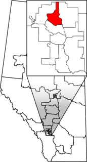
Bearberry is an unincorporated community in central Alberta in Mountain View County, located 18 kilometres (11 mi) west of Highway 22, 107 kilometres (66 mi) northwest of Calgary. It is named for the bearberry that grows in the vicinity. [1]

Central Alberta region in the province of Alberta, Canada

Central Alberta is a region located in the Canadian province of Alberta.

Mountain View County Municipal district in Alberta, Canada

Mountain View County is a municipal district in Division No. 6 in the central Alberta, Canada. Located between the cities of Calgary and Red Deer within the Calgary-Edmonton corridor, its municipal office is located north of the Town of Didsbury. Mountain View County is a member of the Central Alberta Economic Partnership, Alberta Association of Municipal Districts and Counties, and the Municipal Area Partnership.

Alberta Highway 22 highway in Alberta

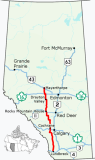
Alberta Provincial Highway No. 22, commonly referred to as Highway 22 and officially named Cowboy Trail, is a 584-kilometre (363 mi) highway in the Canadian province of Alberta. It generally parallels Highway 2, beginning in the foothills of southern Alberta at Highway 3 near Lundbreck Falls. It proceeds north along the eastern slopes of the Rocky Mountains passing through the foothills and ranch country to the aspen parkland of northern Alberta, ending at Highway 18 near Mayerthorpe.

There was a major forest fire, the Dogrib Fire, in 2001, which threatened the community. [2] In 2003, a major bridge was reconstructed in Bearberry. [3] Shell Oil has a plant near the community. [4] "Sour gas" is mined in and around Bearberry. [5]

Sour gas is natural gas or any other gas containing significant amounts of hydrogen sulfide (H2S).

It is a tourist destination with snowmobile trails, [6] and is also the site of a bed and breakfast. [7] The area west of the community is described as "pristine wilderness area [that] is also home to the bear, wolf and cougar whose prey includes wild horses." [8]

Bed and breakfast small lodging establishment

A bed and breakfast is a small lodging establishment that offers overnight accommodation and breakfast. Bed and breakfasts are often private family homes and typically have between four and eleven rooms, with six being the average. In addition, a B&B usually has the hosts living in the house.

Bear Family of mammals

Bears are carnivoran mammals of the family Ursidae. They are classified as caniforms, or doglike carnivorans. Although only eight species of bears are extant, they are widespread, appearing in a wide variety of habitats throughout the Northern Hemisphere and partially in the Southern Hemisphere. Bears are found on the continents of North America, South America, Europe, and Asia. Common characteristics of modern bears include large bodies with stocky legs, long snouts, small rounded ears, shaggy hair, plantigrade paws with five nonretractile claws, and short tails.

Cougar Large cat of the family Felidae native to the Americas

The cougar, also commonly known by other names including catamount, mountain lion, panther, and puma, is a large felid of the subfamily Felinae native to the Americas. Its range, from the Canadian Yukon to the southern Andes of South America, is the widest of any large wild terrestrial mammal in the Western Hemisphere. An adaptable, generalist species, the cougar is found in most American habitat types. It is the biggest cat in North America, and the second-heaviest cat in the New World after the jaguar. Secretive and largely solitary by nature, the cougar is properly considered both nocturnal and crepuscular, although daytime sightings do occur. The cougar is more closely related to smaller felines, including the domestic cat, than to any species of subfamily Pantherinae, of which only the jaguar is native to the Americas.

Related Research Articles

Monmouth County, New Jersey County in the United States

Monmouth County is a county located in Central New Jersey, in the United States within the New York metropolitan area, and the northernmost county along the Jersey Shore. As of the 2017 Census estimate, the county's population was 626,351, making it the state's fifth-most populous county, representing a decrease of 0.6% from the 2010 Census, when the population was enumerated at 630,380, in turn an increase of 15,079 from 615,301 at the 2000 Census. As of 2010, the county fell to the fifth-most populous county in the state, having been surpassed by Hudson County. Its county seat is Freehold Borough. The most populous place was Middletown Township, with 66,522 residents at the time of the 2010 Census, while Howell Township covered 61.21 square miles (158.5 km2), the largest total area of any municipality.

Middlesex County, New Jersey County in the United States

Middlesex County is a county located in central New Jersey, United States. In 2017 the Census Bureau estimated the county's population at 842,798, making it the state's second-most populous county, an increase of 4.1% from 809,858 in the 2010 census. Middlesex is part of the New York metropolitan area, and its county seat is New Brunswick. The center of population of the state of New Jersey is located in Middlesex County, in East Brunswick Township, just east of the New Jersey Turnpike. The 2000 Census showed that the county ranked 63rd in the United States among the highest-income counties by median household. The Bureau of Economic Analysis ranked the county as having the 143rd-highest per capita income of all 3,113 counties in the United States as of 2009. Middlesex County holds the nickname, "The Greatest County in the Land".

Telus Canadian telecommunications company

Telus Corporation is a Canadian national telecommunications company that provides a wide range of telecommunications products and services including internet access, voice, entertainment, healthcare, video, and IPTV television. The company is based in the Vancouver, British Columbia area; it was originally based in Edmonton, Alberta, before its merger with BCTel in 1999. Telus' wireless division, Telus Mobility, offers HSPA+, and LTE-based mobile phone networks. Telus is the incumbent local exchange carrier in British Columbia and Alberta. Telus' primary competitors are Shaw Communications, and Bell Canada and Vidéotron.

Chatteris civil parish and one of the four market towns in the Fenland district of Cambridgeshire, England

Chatteris is a civil parish and one of the four market towns in the Fenland district of Cambridgeshire, England, situated in The Fens between Huntingdon, March and Ely. The town is in the North East Cambridgeshire parliamentary constituency.

Fort Macleod Town in Alberta, Canada

Fort Macleod, originally named Macleod, is a town in the southwest corner of the province of Alberta, Canada. It was founded as a North-West Mounted Police barracks, and is named in honour of the North-West Mounted Police Colonel James Macleod. It was known as the Town of Macleod between 1892 and 1912.

Vermilion, Alberta Town in Alberta, Canada

Vermilion is a town in central Alberta, Canada within the County of Vermilion River. It is located at the intersection of Highway 16 and Highway 41, approximately 60 kilometres (37 mi) west of Lloydminster and 192 kilometres (119 mi) east of Edmonton.

Calgary Nose Hill Federal electoral district

Calgary Nose Hill is a federal electoral district in Alberta, Canada, that has been represented in the House of Commons of Canada since 1997.

Balzac, Alberta Hamlet in Alberta, Canada

Balzac is a hamlet in the southern portion of the Canadian province of Alberta, in Rocky View County. It is located immediately west of Queen Elizabeth II Highway, at the intersection with Highway 566, 24 km (15 mi) north of Calgary city centre and 12 km (7.5 mi) south of Airdrie.

Trochu, Alberta Town in Alberta, Canada

Trochu is a town in central Alberta, Canada. It is located 15 km (9.3 mi) north of Three Hills at the junction of Highway 21 and Highway 585, in Kneehill County.

Cochrane Lake, Alberta

Cochrane Lake is a hamlet in southern Alberta under the jurisdiction of Rocky View County. Statistics Canada also recognizes a smaller portion of the hamlet as a designated place under the name of Cochrane Lake Subdivision.

International Gay Rodeo Association

The International Gay Rodeo Association (IGRA), founded in 1985, is the sanctioning body for gay rodeos held throughout the United States and Canada. They are the largest group coordinating rodeo events specifically welcoming lesbian, gay, bisexual, transgender (LGBT) as well as heterosexual participants and spectators. IGRA is composed of many regional gay rodeo associations, and sanctions a season of rodeo events which culminates in an annual World Gay Rodeo Finals. IGRA events are intended to allow all competitors, regardless of sexual and gender identity, to compete in rodeo sports without discrimination. The organization helps spread appreciation for Western culture and the sport of rodeo, while serving as a fundraising vehicle benefiting many charitable organizations.

Tomahawk, Alberta Hamlet in Alberta, Canada

Tomahawk, Alberta is a hamlet in Alberta, Canada within Parkland County. It is located on Highway 759, northeast of the Town of Drayton Valley.

Carvel, Alberta Hamlet in Alberta, Canada

Carvel is a hamlet in Alberta, Canada within Parkland County. It is located on Highway 770, approximately 35 kilometres (22 mi) west of Edmonton. The hamlet's name is derived from the novel Richard Carvel by the American writer Winston Churchill.

Energy law

Energy laws govern the use and taxation of energy, both renewable and non-renewable. These laws are the primary authorities related to energy. In contrast, energy policy refers to the policy and politics of energy.

Half Moon Lake, Alberta Hamlet in Alberta, Canada

Half Moon Lake is a hamlet in Alberta, Canada within Strathcona County. It is also recognized as a designated place by Statistics Canada under the name of Half Moon Estates. The community is located on the shores of Half Moon Lake, just north of Highway 629, approximately 13 kilometers (8.1 mi) southeast of Sherwood Park.

Alsike, Alberta human settlement in Canada

Alsike is an unincorporated place in central Alberta in Leduc County, located on Highway 39, Highway 22. It is 61 kilometres (38 mi) west of Leduc. The first general store opened in 1938.

Beach Corner, Alberta human settlement in Canada

Beach Corner is an unincorporated community in central Alberta in Parkland County, located on Highway 16A, 43 kilometres (27 mi) west of Edmonton.

Keephills

Keephills is a hamlet in central Alberta, Canada within Parkland County. It is located approximately 19 kilometres (12 mi) south of Highway 16 and 64 kilometres (40 mi) southwest of Edmonton. A nearby employer is the Keephills Generating Station.

References

  1. "Species of Arctostaphylos (Bearberry)," found at Alberta Biodiversity Monitoring Institute website Archived July 6, 2011, at the Wayback Machine .. Accessed January 11, 2010.
  2. "Senior Researcher with FERIC Wildland Fire Operations Research Group Collaborates with ASRD Forest Protection Division Staff in the Continuing Development of PROMETHEUS," found at FERIC website Archived July 6, 2011, at the Wayback Machine .. Accessed January 11, 2010.
  3. USL newsletter December 2003 Archived July 17, 2011, at the Wayback Machine .. Accessed January 11, 2010.
  4. Onquest website Archived February 7, 2010, at the Wayback Machine .. Accessed January 11, 2010.
  5. Bruce E. Roberts, "The Effect of Sulfur Deposition on Gaswell Inflow Performance," Journal SPE Reservoir Engineering , Volume 12, Number 2 (May 1997) pp. 118-123. Found at One Petro website. Accessed January 11, 2010.
  6. Best Western Alberta website Archived July 7, 2011, at the Wayback Machine .. Accessed January 11, 2010.
  7. A bed in Heaven website. Accessed January 11, 2010.
  8. Doreen, "Archive for the 'Wyley The Wildie' Category: Wyley’s Rescue," January 5, 2007, found at Wild Horses of Alberta Society website. Accessed January 11, 2010.

Coordinates: 51°51′14″N114°55′23″W / 51.85389°N 114.92306°W / 51.85389; -114.92306 (Bearberry)

Geographic coordinate system Coordinate system

A geographic coordinate system is a coordinate system that enables every location on Earth to be specified by a set of numbers, letters or symbols. The coordinates are often chosen such that one of the numbers represents a vertical position and two or three of the numbers represent a horizontal position; alternatively, a geographic position may be expressed in a combined three-dimensional Cartesian vector. A common choice of coordinates is latitude, longitude and elevation. To specify a location on a plane requires a map projection.