Brooks Aqueduct

Last updated

Brooks Aqueduct
Brooks Aqueduct National Historic Site.JPG
Type aqueduct
Location Brooks, Alberta, Canada
Nearest city County of Newell
Coordinates 50°31′44″N111°51′18″W / 50.5289°N 111.8550°W / 50.5289; -111.8550
Built1912–1914
Original use Aqueduct
Governing body Parks Canada
Website Brooks Aqueduct
Official nameBrooks Aqueduct National Historic Site of Canada
Designated18 November 1983
Official nameBrooks Aqueduct
Designated20 July 2000
Alberta County Point Locator.svg
Red pog.svg
Location of Brooks Aqueduct in Alberta

The Brooks Aqueduct is a defunct aqueduct, historic site and museum originally built by the irrigation division of the Canadian Pacific Railway Company during the early 1910s located in Southern Alberta, Canada. The aqueduct was intended to irrigate a section of southeastern Alberta by diverting water east from Lake Newell from 1914 to 1979, and is located approximately 8 kilometres south of the City of Brooks. The main section of the aqueduct spans a 3.2 km valley at an average elevation of 20 metres. The structure has been designated a National Historic Site with an interpretive centre constructed nearby for tourists. [1]

Contents

History

The Brooks Aqueduct was conceived by the Canadian Pacific Railway (CPR) as a mechanism to irrigate a portion of the Palliser's Triangle in southern Alberta. CPR received a 12,000-square-kilometre (3-million-acre) block of land between Calgary and Medicine Hat as a payment for the completion of the transcontinental railway, which was divided into the Western, Central and Eastern sections. [2] The Eastern section of the land grant provided access to the Bow River and the reservoir at the Bassano Dam, which was fed to agricultural operations through a series of canals and irrigation projects built by CPR. [3] [4] Hugh B. Muckleston, the Assistant Chief Engineer for the Department of Natural Resources for CPR was the first to envision the Brooks Aqueduct, noting an earthen filled canal would be inconceivable given the terrain conditions. [5] The decision was made to use reinforced Portland cement [6] with an open flume designed as a hydrostatic catenary curve. [7] The design also incorporated expansion joints to allow for movement along the long aqueduct due to expansion and contraction with varying temperatures, the joints were made primarily of copper. The expansion joints were placed every 24 metres (80 ft) or fourth bent. [8] To cross the CPR main line, a siphon was built which operated on the Venturi principle 12 metres (40 ft) under the railway tracks. [9]

The firm of Grant, Smith & Co. & McDonnell of Vancouver was contracted to construct the Brooks Aqueduct between 1912 and 1914. [10] At its completion in 1914, and beginning of operations in 1915 the CA$700,000, [11] at a length of 3.1 kilometres Brooks Aqueduct claimed to be the largest concrete structure in existence. [12] [13] The copper expansion joints had significant leaks following construction which caused damage to the concrete supports, this was mitigated by drainage ditches and efforts to reduce the leakage, furthermore the alkalinity of the water conveyed, combined with frost accumulation caused unavoidable deterioration to the concrete structure. CPR continued to refurbish the aqueduct through the 1920s and early 1930s, spraying gunnite over the rotting pedestals and flaking concrete shells. [14] Following the completion of these upgrades in 1934 the Brooks Aqueduct was transferred to the Eastern Irrigation District, a farmer-owned entity formed under the Irrigation Districts Act in 1935, this was part of a larger divestment in the region by CPR. [12] [15] The aqueduct was used for irrigation for about 30 years. Its original capacity was 25 m3/s (900 cu ft/s). [16] and the 113,000 hectares of land which were provided with water led to a new wave of settlement. [17]

In 1969, the Alberta and Canadian governments assumed the responsibility of maintaining the structure under the Prairie Farm Rehabilitation Administration. The Brooks Aqueduct and Bassano Dam were evaluated, and it was found that the dam would require minor rehabilitation, while the aqueduct was no longer suitable for operations. A series of earthen canals were constructed as a replacement for the aqueduct, and after evaluating the cost of demolishing the structure, the governments decided it would be more financially prudent to fence the aqueduct off from the public. [18]

Legacy

The Brooks Aqueduct continues to stand to this day, although the structure itself is no longer structurally sound and has been fenced off since the 1970s. The Brooks Aqueduct and the immediate surrounding area was designated a National Historic Site of Canada on 18 November 1983 by the Government of Canada. [1] [19] The Brooks Aqueduct would later be designated a Provincial Historical Resource by the Government of Alberta on 20 July 2000. [15]

Brooks Aqueduct Historic Site Plaque Brooks Aqueduct Historic Site Plaque.JPG
Brooks Aqueduct Historic Site Plaque

Related Research Articles

<span class="mw-page-title-main">Kettle Valley Railway</span> Former subsidiary of the Canadian Pacific Railway on British Columbia

The Kettle Valley Railway was a subsidiary of the Canadian Pacific Railway (CPR) that operated across southern British Columbia, west of Midway running to Rock Creek, then north to Myra Canyon, down to Penticton over to Princeton, Coalmont, Brookmere, Coquihalla and finally Hope where it connected to the main CPR line.

<span class="mw-page-title-main">Alexandra Bridge</span> Steel truss cantilever bridge connecting Ottawa, Ontario, and Gatineau, Quebec

The Royal Alexandra Interprovincial Bridge, also known as the Alexandra Bridge or Interprovincial Bridge, is a steel truss cantilever bridge spanning the Ottawa River between Ottawa, Ontario and Gatineau, Quebec. In addition to carrying vehicle traffic, a shared use pathway on the bridge for pedestrians and cyclists is maintained by the National Capital Commission.

<span class="mw-page-title-main">Bow River</span> River in Alberta, Canada

The Bow River is a river in Alberta, Canada. It begins within the Canadian Rocky Mountains and winds through the Alberta foothills onto the prairies, where it meets the Oldman River, the two then forming the South Saskatchewan River. These waters ultimately flow through the Nelson River into Hudson Bay. The Bow River runs through the city of Calgary, taking in the Elbow River at the historic site of Fort Calgary near downtown. The Bow River pathway, developed along the river's banks, is considered a part of Calgary's self-image.

<span class="mw-page-title-main">William Cornelius Van Horne</span> American-Canadian businessman and art collector (1843–1915)

Sir William Cornelius Van Horne, is most famous for overseeing the construction of the first Canadian transcontinental railway, a project that was completed in 1885, in under half the projected time. He succeeded Lord Mount Stephen as president of the Canadian Pacific Railway (CPR) in 1888. He was responsible for launching the sea transport division of the CPR, which inaugurated regular service between Vancouver and Hong Kong in 1891. He also presided over the expansion of the CPR into the luxury hotel business in the 1890s. He was also a prominent member of the syndicate that created the Cuba Railroad Company in 1900. He lived at the Van Horne Mansion in Montreal's Golden Square Mile.

<span class="mw-page-title-main">Brent Butt</span> Canadian actor, comedian, and writer

Brent Leroy Butt is a Canadian actor, comedian, and screenwriter. He is best known for his role as Brent Leroy on the CTV sitcom Corner Gas, which he created. He also created the television series Hiccups and wrote the 2013 film No Clue.

<span class="mw-page-title-main">Brooks, Alberta</span> City in Alberta, Canada

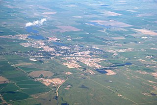
Brooks is a city in southeast Alberta, Canada in the County of Newell. It is located on Highway 1 and the Canadian Pacific Railway, approximately 186 km (116 mi) southeast of Calgary, and 110 km (68 mi) northwest of Medicine Hat. The city has an elevation of 760 m (2,490 ft).

<span class="mw-page-title-main">Flume</span> Human-made channel for water

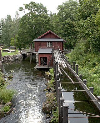
A flume is a human-made channel for water, in the form of an open declined gravity chute whose walls are raised above the surrounding terrain, in contrast to a trench or ditch. Flumes are not to be confused with aqueducts, which are built to transport water, rather than transporting materials using flowing water as a flume does. Flumes route water from a diversion dam or weir to a desired materiel collection location. Flumes are usually made up of wood, metal or concrete.

Heritage Park Historical Village is a historical park in Calgary, Alberta, Canada, on 127 acres (51 ha) of parkland on the banks of the Glenmore Reservoir, along the city's southwestern edge. The Historical Village is open from late May to Thanksgiving and Heritage Town Square is open year-round. As Canada's second largest living history museum, it is one of the city's most visited tourist attractions. Exhibits span western Canadian history from the 1860s to the 1950s. Many of the buildings are historical and were transported to the park to be placed on display. Others are re-creations of actual buildings. Most of the structures are furnished and decorated with genuine artifacts. Staff dress in historic costume, and antique automobiles and horse-drawn vehicles service the site. Calgary Transit provides regular shuttle service from Heritage C-Train station. The park opened on July 1, 1964.

<span class="mw-page-title-main">Northern Alberta Railways</span> Railway in Alberta and British Columbia, Canada

Northern Alberta Railways was a Canadian railway which served northern Alberta and northeastern British Columbia. Jointly owned by both Canadian National Railway and Canadian Pacific Railway, NAR existed as a separate company from 1929 until 1981.

<span class="mw-page-title-main">Stirling, Alberta</span> Village in Alberta, Canada

Stirling is a village in southern Alberta, Canada that is surrounded by the County of Warner No. 5. The village is located on Highway 4, approximately 31 km (19 mi) southeast of Lethbridge and 72 km (45 mi) northwest of the Canada–US border.

<span class="mw-page-title-main">Huron Central Railway</span> Railway in Ontario, Canada

The Huron Central Railway is a railway operating in northern Ontario, Canada. It is operated by Genesee & Wyoming Canada, the Canadian subsidiary of Genesee & Wyoming.

Cheadle is a hamlet in Alberta, Canada within Wheatland County. It is located on Highway 24, 2 kilometers (1.2 mi) south of the Highway 1 and approximately 35 kilometers (22 mi) east of the City of Calgary.

<span class="mw-page-title-main">Provincial historic sites of Alberta</span>

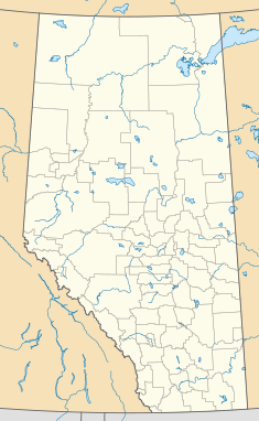
Provincial historic sites of Alberta are museums and historic sites run by the Government of Alberta.

<span class="mw-page-title-main">Maybutt, Alberta</span> Settlement in Alberta, Canada (est. 1890)

Maybutt, also known as "New Stirling" or "New Town", is a former locality in the County of Warner No. 5, Alberta, Canada. The community is situated 1 km north of the Village of Stirling just off the CANAMEX Corridor between Lethbridge and the Canada–US border. The community has become a bedroom community to Lethbridge, with many newer acreages being developed in the area. The footprint of Maybutt is defined by its historic boundary roads, Young St., Sunnyside Ave., Front St. & Lorne Ave, and Etzikom Ave. York St., First Ave. and Second Ave. are the only interior streets left of the original street grid of Maybutt.

<span class="mw-page-title-main">Retlaw, Alberta</span> Unincorporated community in Alberta, Canada

Retlaw is an unincorporated community located in the Municipal District of Taber, Alberta, Canada. The community once had a peak population of over 250 citizens and was even incorporated under the status of a village until it was dissolved into a hamlet under the jurisdiction of Improvement District No. 96 on March 1, 1939. Retlaw is located 2 km (1 mi) west of Highway 864 6 km (3 mi) west of Vauxhall and 42 km (26 mi) northwest of Taber and 75 km (46 mi) southwest of Brooks.

Suffield is a hamlet in southern Alberta, Canada within Cypress County. It is located on the Trans-Canada Highway approximately 32 km (20 mi) northwest of Medicine Hat, and just south of CFB Suffield.

The Warner elevator row is a group of four historic wood-cribbed grain elevators standing in a row from south to north alongside the Canadian Pacific Railway line from Great Falls, Montana to Lethbridge, Alberta at the east entrance of the village of Warner, Alberta, Canada. At one time, the row had at least seven elevators.

<span class="mw-page-title-main">Miami Railway Station</span> Railway station in Manitoba, Canada

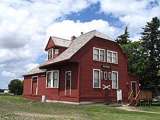
The Miami Railway Station is a former railway station that was built in Miami, Manitoba, by the Northern Pacific and Manitoba Railway Company in 1889. Designated as a National Historic Site of Canada in 1976, it is now a railway museum that operates during the summer. The museum is at the southern end of the village near the intersection of Highway 23 and Letain Street.

William Pearce (1848–1930), was a surveyor, statistician, planner, and administrator in western Canada. He served in the federal government from 1874 to 1904 as federal surveyor and administrator, as federal advisor for western development and as Western consultant for the Canadian Pacific Railway Company. As Inspector of Dominion Lands Agencies, he oversaw the "development and allocation of all land, forests, mineral and water resources" from "Winnipeg to the eastern foothills of the Rockies"—representing 400,000 square miles of land, earning his nickname—"Czar of the West". He was known for his work on the Bow River watershed irrigation systems that transformed lands in southern Alberta into fertile land.

References

  1. 1 2 Jayne Seagrave (30 April 2015). Camping with Kids in the West: BC and Alberta's Best Family Campgrounds. Heritage House. p. 159. ISBN   978-1-77203-041-9.
  2. "Canadian Pacific Railway". The Official Brooks Aqueduct Home Page. Retrieved 5 August 2020.
  3. Ted Stone (1996). Alberta History Along the Highway: A Traveler's Guide to the Fascinating Facts, Intriguing Incidents and Lively Legends in Alberta's Past. Red Deer College Press. p. 79. ISBN   978-0-88995-133-4.
  4. "The Eastern Section". The Official Brooks Aqueduct Home Page. Retrieved 5 August 2020.
  5. "Introduction to the Brooks Aqueduct". The Official Brooks Aqueduct Home Page. Retrieved 5 August 2020.
  6. Engineering News. Vol. 77. G.H. Frost. 1917. p. 469.
  7. "Flume Design". The Official Brooks Aqueduct Home Page. Retrieved 5 August 2020.
  8. "Expansion Joints". The Official Brooks Aqueduct Home Page. Retrieved 5 August 2020.
  9. "Siphon Design". The Official Brooks Aqueduct Home Page. Retrieved 5 August 2020.
  10. "Construction". The Official Brooks Aqueduct Home Page. Retrieved 5 August 2020.
  11. "Brooks Aqueduct". Alberta Heritage Survey Program. Government of Alberta. Retrieved 4 August 2020.
  12. 1 2 Ron Brown (30 June 2012). Rails Across the Prairies: The Railway Heritage of Canada's Prairie Provinces. Dundurn. p. 22. ISBN   978-1-4597-0216-5.
  13. The Interpreter. Western Interpreters Association. 1979. pp. 19–20.
  14. "Maintenance". The Official Brooks Aqueduct Home Page. Retrieved 5 August 2020.
  15. 1 2 Brooks Aqueduct . Canadian Register of Historic Places . Retrieved August 4, 2020.
  16. Engineering Works of Calgary. 1915. p. 16. Archived from the original on 2015-09-24. Retrieved 2013-08-01.
  17. Ron Brown (8 August 2015). Dundurn Railroad 5-Book Bundle: In Search of the Grand Trunk / Rails Across the Prairies / Rails Across Ontario / The Train Doesn't Stop Here Anymore / Rails to the Atlantic. Dundurn. p. 699. ISBN   978-1-4597-3303-9.
  18. "The Fate of the Brooks Aqueduct". The Official Brooks Aqueduct Home Page. Retrieved 5 August 2020.
  19. Brooks Aqueduct National Historic Site of Canada . Canadian Register of Historic Places . Retrieved August 4, 2020.