Drift Pile River 150

Last updated
Drift Pile River 150
ᒥᐦᑎᐦᑕᑳᐤ ᓰᐱᐩ
mihtihtakâw sîpiy
Drift Pile River Indian Reserve No. 150
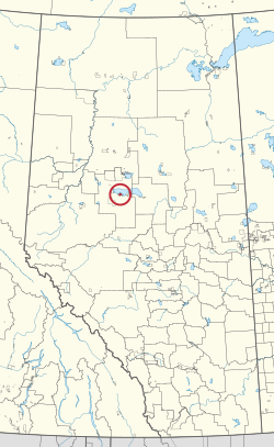
CAN AB 95 DRIFTPILE RIVER INDIAN RESERVE -150.svg
Location in Alberta
First Nation Driftpile Cree
Treaty 8
Country Canada
Province Alberta
Municipal district Big Lakes
Area
[1]
  Total6,354.8 ha (15,703.1 acres)
Population
 (2016) [2]
  Total828
  Density13/km2 (34/sq mi)

Drift Pile River 150 is an Indian reserve of the Driftpile Cree Nation in Alberta, located within Big Lakes County. [3] It is 6 kilometers southeast of Lesser Slave Lake. [1] In the 2016 Canadian Census, it recorded a population of 828 living in 258 of its 277 total private dwellings. [2]

Related Research Articles

<span class="mw-page-title-main">Division No. 17, Alberta</span> Census division in Alberta, Canada

Division No. 17 is a census division in Alberta, Canada. It spans the central and northwest portions of northern Alberta and its largest urban community is the Town of Slave Lake. Division No. 17 is the largest census division in Alberta according to area and also has the lowest population density.

<span class="mw-page-title-main">Utikoomak Lake 155</span> Indian reserve in Whitefish Lake

Utikoomak Lake 155 is an Indian reserve of the Whitefish Lake First Nation in Alberta, located within Northern Sunrise County and Big Lakes County. It is 61 kilometers north of High Prairie. In the 2016 Canadian Census, it recorded a population of 723 living in 158 of its 193 total private dwellings.

Driftpile is a community on the Drift Pile River 150 Indian reserve, in northern Alberta, Canada. It is located on Highway 2, approximately 191 kilometres (119 mi) east of Grande Prairie.

<span class="mw-page-title-main">Assineau River 150F</span> Indian reserve in Swan River

Assineau River 150F is an Indian reserve of the Swan River First Nation in Alberta, located within the Municipal District of Lesser Slave River No. 124.

<span class="mw-page-title-main">Cowper Lake 194A</span> Indian reserve in Chipewyan Prairie

Cowper Lake 194A is an Indian reserve of the Chipewyan Prairie First Nation in Alberta, located within the Regional Municipality of Wood Buffalo.

<span class="mw-page-title-main">Driftpile First Nation</span>

The Driftpile First Nation is a Treaty 8 First Nation with a reserve, Drift Pile River 150, located on the southern shore of the Lesser Slave Lake on Alberta Highway 2 in Northern Alberta. The band has approximately 1200 members.

<span class="mw-page-title-main">Kapawe'no 150B</span> Indian reserve in Kapaweno

Kapawe'no 150B, historically known as Freeman 150B, is an Indian reserve of the Kapawe'no First Nation in Alberta, located within Big Lakes County. It is 8 kilometers northwest of Lesser Slave Lake. In the 2016 Canadian Census, it recorded a population of 154 living in of its 45 total private dwellings.

<span class="mw-page-title-main">Sucker Creek 150A</span> Indian reserve in Sucker Creek

Sucker Creek 150A is an Indian reserve of the Sucker Creek First Nation in Alberta, located within Big Lakes County. It is 22 kilometres south of High Prairie. In the 2016 Canadian Census, it recorded a population of 689 living in 235 of its 274 total private dwellings.

<span class="mw-page-title-main">Utikoomak Lake 155A</span> Indian reserve in Whitefish Lake

Utikoomak Lake 155A is an Indian reserve of the Whitefish Lake First Nation in Alberta, located within Northern Sunrise County. In the 2016 Canadian Census, it recorded a population of 127 living in 29 of its 34 total private dwellings.

<span class="mw-page-title-main">Sawridge 150H</span> Indian reserve in Sawridge First Nation

Sawridge 150H is an Indian reserve of the Sawridge First Nation in Alberta, located within the Municipal District of Lesser Slave River No. 124. It is west of the town of Slave Lake.

<span class="mw-page-title-main">Sawridge 150G</span> Indian reserve in Sawridge First Nation

Sawridge 150G is an Indian reserve of the Sawridge First Nation in Alberta, located within the Municipal District of Lesser Slave River No. 124. It is adjacent to the eastern boundary of the town of Slave Lake.

<span class="mw-page-title-main">Heart Lake 167A</span> Indian reserve in Heart Lake

Heart Lake 167A is an Indian reserve of the Heart Lake First Nation in Alberta, located within Lac La Biche County.

<span class="mw-page-title-main">Kapawe'no 150C</span> Indian reserve in Kapaweno

Kapawe'no 150C, formerly known as Halcro 150C, is an Indian reserve of the Kapawe'no First Nation in Alberta, located within Big Lakes County. It is 17 kilometres northeast of High Prairie.

<span class="mw-page-title-main">Kapawe'no 150D</span> Indian reserve in Kapaweno

Kapawe'no 150D, formerly known as Pakashan 150D, is an Indian reserve of the Kapawe'no First Nation in Alberta, located within Big Lakes County. It is 13 kilometres northwest of Lesser Slave Lake. In the 2016 Canadian Census, it recorded a population of 5 living in 4 of its 7 total private dwellings.

<span class="mw-page-title-main">Kapawe'no 231</span> Indian reserve in Kapaweno

Kapawe'no 231 is an Indian reserve of the Kapawe'no First Nation in Alberta, located within Big Lakes County. It is 86 kilometres north of Swan Hills.

<span class="mw-page-title-main">Loon Lake 235</span> Indian reserve in Loon River

Loon Lake 235 is an Indian reserve of the Loon River First Nation in Alberta, located within Northern Sunrise County and the Municipal District of Opportunity No. 17. It is 5 kilometres southwest of Loon Lake. In the 2016 Canadian Census, it recorded a population of 555 living in 147 of its 157 total private dwellings.

<span class="mw-page-title-main">Loon Prairie 237</span> Indian reserve in Loon River

Loon Prairie 237 is an Indian reserve of the Loon River First Nation in Alberta, located within Northern Sunrise County. It is 30 kilometres north of Loon Lake.

<span class="mw-page-title-main">Swampy Lake 236</span> Indian reserve of the Loon River First Nation in Alberta, Canada

Swampy Lake 236 is an Indian reserve of the Loon River First Nation in Alberta, located within Northern Sunrise County. It is 6 kilometres west of Loon Lake.

<span class="mw-page-title-main">Utikoomak Lake 155B</span> Indian reserve in Whitefish Lake

Utikoomak Lake 155B is an Indian reserve of the Whitefish Lake First Nation in Alberta, located within Northern Sunrise County. It is fifty-five kilometres (34 mi) northeast of High Prairie.

<span class="mw-page-title-main">Wadlin Lake 173C</span> Indian reserve in Tallcree

Wadlin Lake 173C is an Indian reserve of the Tallcree First Nation in Alberta, located within Mackenzie County. It is 91 kilometres east of Carcajou.

References

  1. 1 2 "Reserve/Settlement/Village Detail". Crown–Indigenous Relations and Northern Affairs Canada . Government of Canada. Retrieved August 12, 2019.
  2. 1 2 "Census Profile, 2016 Census". Statistics Canada. February 8, 2017. Retrieved 2019-08-10.
  3. Government of Alberta (May 25, 2019). Municipal Boundaries (Map). AltaLIS.

55°21′51″N115°46′16″W / 55.3643°N 115.7711°W / 55.3643; -115.7711 (Drift Pile River 150)