Whirlpool River

Last updated
Whirlpool River

WhirlpoolRiverAB2.JPG

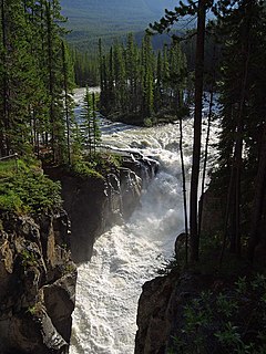
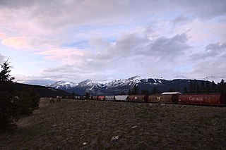
The Whirlpool River from Alberta Highway 93A
CountryFlag of Alberta.svg  Alberta Flag of Canada.svg  Canada
Physical characteristics
Main source Athabasca Pass
1,704 m (5,591 ft)
52°23′46″N118°12′15″W / 52.39611°N 118.20417°W / 52.39611; -118.20417
River mouth Athabasca River
1,121 m (3,678 ft)
52°44′06″N117°57′15″W / 52.73500°N 117.95417°W / 52.73500; -117.95417 Coordinates: 52°44′06″N117°57′15″W / 52.73500°N 117.95417°W / 52.73500; -117.95417
The Whirlpool in Jasper National Park WhirlpoolRiverAB1.JPG
The Whirlpool in Jasper National Park

The Whirlpool River is a short river in Jasper National Park, Alberta, Canada. It is an early tributary of the Athabasca River.

River Natural flowing watercourse

A river is a natural flowing watercourse, usually freshwater, flowing towards an ocean, sea, lake or another river. In some cases a river flows into the ground and becomes dry at the end of its course without reaching another body of water. Small rivers can be referred to using names such as stream, creek, brook, rivulet, and rill. There are no official definitions for the generic term river as applied to geographic features, although in some countries or communities a stream is defined by its size. Many names for small rivers are specific to geographic location; examples are "run" in some parts of the United States, "burn" in Scotland and northeast England, and "beck" in northern England. Sometimes a river is defined as being larger than a creek, but not always: the language is vague.

Jasper National Park national park in the Canadian Rockies

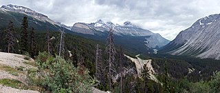
Jasper National Park is the largest national park in the Canadian Rockies, spanning 11,000 km2 (4,200 sq mi). It is located in the province of Alberta, north of Banff National Park and west of Edmonton. The park includes the glaciers of the Columbia Icefield, hot springs, lakes, waterfalls and mountains.

Alberta Province of Canada

Alberta is a western province of Canada. With an estimated population of 4,067,175 as of 2016 census, it is Canada's fourth most populous province and the most populous of Canada's three prairie provinces. Its area is about 660,000 square kilometres (250,000 sq mi). Alberta and its neighbour Saskatchewan were districts of the Northwest Territories until they were established as provinces on September 1, 1905. The premier has been Rachel Notley since 2015.

Contents

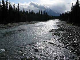
The Whirlpool is formed in Athabasca Pass, collecting meltwater from the Hooker Icefield and the Mount Brown Icefield. It flows north, collecting the Middle Whirlpool River before passing under Alberta Highway 93A and flowing into the Athabasca River south of Jasper. The Moab Lake Road parallels the Whirlpool near its confluence with the Athabasca River.

Athabasca Pass

Athabasca Pass is a high mountain pass in the Canadian Rockies. It is the headwaters of the Whirlpool River, a tributary of the Athabasca River. In fur-trade days it connected Jasper House on the Athabasca River with Boat Encampment on the Columbia River.

Jasper, Alberta Specialized municipality in Alberta, Canada

Jasper is a specialized municipality in western Alberta, Canada. It is the commercial centre of Jasper National Park, located in the Canadian Rockies within the Athabasca River valley. Jasper is approximately 362 kilometres (225 mi) west of Edmonton and 290 kilometres (180 mi) north of Banff, Alberta, at the intersection of Highway 16 and Highway 93.

Confluence Meeting of two or more bodies of flowing water

In geography, a confluence occurs where two or more flowing bodies of water join together to form a single channel. A confluence can occur in several configurations: at the point where a tributary joins a larger river ; or where two streams meet to become the source of a river of a new name ; or where two separated channels of a river rejoin at the downstream end.

The Whirlpool was named by Sir James Hector in 1859. He noted the presence of many eddies in the river. [1]

Tributaries

See also

Related Research Articles

Athabasca River river in Canada

The Athabasca River originates from the Columbia Glacier of the Columbia Icefield in Jasper National Park in Alberta, Canada. The impressive and scenic Athabasca Falls is located upstream about 30 km (19 mi) from the Jasper townsite.

Warwick Mountain mountain in the Canadian Rockies

Warwick Mountain is a mountain in Alberta, Canada.

Sunwapta River river in Canada

The Sunwapta River is a major tributary of the Athabasca River in Jasper National Park in Alberta, Canada.

Columbia Icefield icefield located in the Canadian Rockies,

The Columbia Icefield is the largest ice field in the Rocky Mountains. Located in the Canadian Rockies astride the Continental Divide along the border of British Columbia and Alberta, Canada, the ice field lies partly in the northwestern tip of Banff National Park and partly in the southern end of Jasper National Park.

Athabasca Falls waterfall

Athabasca Falls is a waterfall in Jasper National Park on the upper Athabasca River, approximately 30 kilometres south of the townsite of Jasper, Alberta, Canada, and just west of the Icefields Parkway. A powerful, picturesque waterfall, Athabasca Falls is not known so much for the height of the falls, as it is known for its force due to the large quantity of water falling into the gorge. Even on a cold morning in the fall, when river levels tend to be at their lowest, copious amounts of water flow over the falls. The river 'falls' over a layer of hard quartzite and through the softer limestone below carving the short gorge and a number of potholes. The falls can be safely viewed and photographed from various viewing platforms and walking trails around the falls. Access is from the nearby parking lot, which leads off Highway 93A just northeast of the falls. Highway 93A takes off from the nearby Icefields Parkway, and crosses the falls on the way north to the town of Jasper. White water rafting often starts below the falls to travel downstream on the Athabasca River to Jasper.

Maligne Lake lake in Alberta, Canada

Maligne Lake is a lake in Jasper National Park, Alberta, Canada. It is famed for the colour of its water, the surrounding peaks, the three glaciers visible from the lake and Spirit Island, a frequently photographed islet. The lake is located 44 km (27 mi) south of Jasper town, and is accessible by motor vehicle, including shuttle buses from Jasper. Boat tours run to Spirit Island in the spring to autumn season. The 44 km Skyline Trail, Jasper's most popular, highest and above treeline, multi-day hike, begins at Maligne Lake and finishes near the town of Jasper. Other popular day hikes include the Opal Hills and Bald Hills loops. Winter activities include cross-country skiing.

Snow Dome (Canada) mountain on the border of Alberta and British Columbia, Canada

Snow Dome is a mountain located on the Continental Divide in the Columbia Icefield, where the boundary of Banff National Park and Jasper National Park meets the border of Alberta and British Columbia in Canada.

Mount Wilcox (Alberta) mountain in Canada

Mount Wilcox is a 2,884-metre (9,462-foot) mountain summit located in the Canadian Rockies of Alberta, Canada. It is located in Jasper National Park right beside the Columbia Icefield visitor centre with the Icefields Parkway traversing the western base of the mountain. Its nearest higher peak is Nigel Peak, 3.35 km (2.08 mi) to the northeast. Mount Wilcox is a moderate scramble from Wilcox Pass. Because of its location, it provides one of the best views of the Athabasca Glacier.

Albertas Rockies

Alberta's Rockies comprises the Canadian Rockies in the province of Alberta, Canada. It is a region on the southwestern part of the province, along the British Columbia border. It covers all but the south of Census Division 15.

Sunwapta Pass

Sunwapta Pass is a mountain pass in the Canadian Rockies in the province of Alberta. Sunwapta Pass is the low point of the saddle created between Mount Athabasca and Nigel Peak. The pass marks the boundary between Banff and Jasper National Parks. The Icefields Parkway travels through Sunwapta Pass 108 km (67 mi) southeast of the town of Jasper and 122 km (76 mi) northwest of the Parkway's junction with the Trans-Canada Highway near Lake Louise. The pass is the second highest point on the Icefields Parkway. Bow Summit in Banff National Park is the highest point on the parkway.

Fiddle River river in Canada

The Fiddle River is a medium-sized tributary of the Athabasca River, flowing into the river near the east gate of Jasper National Park in Alberta, Canada. The Fiddle River forms at the base of Fiddle Pass, with meltwater from Mount Bryant, Mount Gregg, Mount Sir Harold Mitchel, and Mount Barry. The river flows in a general northeast direction before its confluence with the Athabasca. The Fiddle River parallels the road to the popular Miette Hotsprings for a portion of its course.

Miette River river in Canada

The Miette River is a short river in Jasper National Park, Alberta, Canada. It flows south-southwest through the Rocky Mountains before draining into the Athabasca River.

Embarras River (Alberta) watercourse in Canada

The Embarras River is a short river in west-central Alberta, Canada. The river likely derived its name from the French word for obstruction, because it is often obstructed by driftwood.

The Snake Indian River is a large tributary of the Athabasca River, exiting entirely within Jasper National Park. The Snake Indian forms at Snake Indian Pass, south of Monte Christo Mountain and Snake Indian Mountain, north of Calumet Peak. The river travels in a general northwest direction before turning sharply south. The river plummets over the massive Snake Indian Falls before joining the Athabasca River downstream of Jasper Lake, near the east gate of Jasper National Park.

Astoria River river in Canada

The Astoria River is a short river in Jasper National Park, Alberta, Canada. It is an early tributary of the Athabasca River.

Dragon Peak mountain in Canada

Dragon Peak is a 2,880 metres (9,450 ft) mountain summit located in the Athabasca River valley of Jasper National Park, in the Canadian Rockies of Alberta, Canada. Situated southeast of Mount Christie and Brussels Peak, Dragon Peak can be seen from the Icefields Parkway. The first ascent of the mountain was made in 1979 by D. Waterman. Dragon Peak was named in 1921 by Arthur O. Wheeler on account of a dragon-shaped rock formation. The mountain's name was officially adopted in 1935 by the Geographical Names Board of Canada.

Geraldine Peak

Geraldine Peak is a 2,930-metre (9,610-foot) mountain summit located in the Athabasca River valley of Jasper National Park, in the Canadian Rockies of Alberta, Canada. The peak is also known as Whirlpool Mountain, and Mount Geraldine. No name has been officially adopted yet. The names derive from its position at the northern end of the long ridge that divides Geraldine Lakes and Geraldine Creek on the southeast side, from the Whirlpool River on the northwest side. The nearest higher peak is Mount Fryatt, 7.0 km (4.3 mi) to the south-southeast. Geraldine Peak can be seen from the Icefields Parkway in the vicinity of Athabasca Falls.

Mount Tekarra mountain in Canada

Mount Tekarra is a 2,694 metres mountain summit located in the Athabasca River valley of Jasper National Park, in the Canadian Rockies of Alberta, Canada. It is situated at the northwest end of the Maligne Range and is visible from Jasper and the Icefields Parkway. Its nearest higher peak is The Watchtower, 7.0 km (4.3 mi) to the east.

References

  1. Karamitsanis, Aphrodite (1991). Place Names of Alberta, Volume 1. Calgary: University of Calgary Press, pg. 265