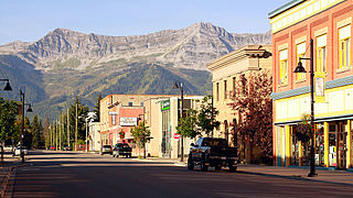
Fernie is a city in the Elk Valley area of the East Kootenay region of southeastern British Columbia, Canada, located on BC Highway 3 on the western approaches to the Crowsnest Pass through the Rocky Mountains. Founded in 1898 and incorporated as the City of Fernie in July 1904, the municipality has a population of over 5,000 with an additional 2,000 outside city limits in communities under the jurisdiction of the Regional District of East Kootenay. A substantial seasonal population swells the city during the winter months.

The Crowsnest Highway is an east-west highway in British Columbia and Alberta, Canada. It stretches 1,161 km (721 mi) across the southern portions of both provinces, from Hope, British Columbia to Medicine Hat, Alberta, providing the shortest highway connection between the Lower Mainland and southeast Alberta through the Canadian Rockies. Mostly two-lane, the highway was officially designated in 1932, mainly following a mid-19th-century gold rush trail originally traced out by an engineer named Edgar Dewdney. It takes its name from the Crowsnest Pass, the location at which the highway crosses the Continental Divide between British Columbia and Alberta.

Crowsnest Pass is a low mountain pass across the Continental Divide of the Canadian Rockies on the Alberta–British Columbia border.

Sparwood is a district municipality in the Canadian province of British Columbia. It is the second-largest community on the Elk River.

The Elk River is a 220-kilometre (140 mi) long river, in the southeastern Kootenay district of the Canadian province of British Columbia. Its drainage basin is 4,450 square kilometres (1,720 sq mi) in area. Its mean discharge is approximately 60 cubic metres per second (2,100 cu ft/s), with a maximum recorded discharge of 818 cubic metres per second (28,900 cu ft/s). It is a tributary of the Kootenay River, and falls within the basin of the Columbia River.

The Municipality of Crowsnest Pass is a specialized municipality in southwest Alberta, Canada. Within the Rocky Mountains adjacent to the eponymous Crowsnest Pass, the municipality formed as a result of the 1979 amalgamation of five municipalities – the Village of Bellevue, the Town of Blairmore, the Town of Coleman, the Village of Frank, and Improvement District No. 5, which included the Hamlet of Hillcrest and numerous other unincorporated communities.

The Regional District of East Kootenay (RDEK) is a regional district in the Canadian province of British Columbia, Canada. In the 2016 census, the population was 60,439. Its area is 27,542.69 km2 (10,634.29 sq mi). The regional district offices are in Cranbrook, the largest community in the region. Other important population centres include the cities of Kimberley and Fernie, and the district municipality of Invermere and Sparwood. Despite its name, the regional district does not include all of the region known as the East Kootenay, which includes the Creston Valley and the east shore of Kootenay Lake.

The Frank Slide was a massive rockslide that buried part of the mining town of Frank in the District of Alberta of the North-West Territories, Canada, at 4:10 a.m. on April 29, 1903. Around 44 million cubic metres/110 million tonnes of limestone rock slid down Turtle Mountain. Witnesses reported that within 100 seconds the rock reached up the opposing hills, obliterating the eastern edge of Frank, the Canadian Pacific Railway (CPR) line and the coal mine. It was one of the largest landslides in Canadian history and remains the deadliest, as between 70 and 90 of the town's residents died, most of whom remain buried in the rubble. Multiple factors led to the slide: Turtle Mountain's formation left it in a constant state of instability. Coal mining operations may have weakened the mountain's internal structure, as did a wet winter and cold snap on the night of the disaster.
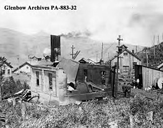
The Hillcrest mine disaster, the worst coal mining disaster in Canadian history, occurred at Hillcrest, Alberta, in the Crowsnest Pass region, on June 19, 1914, 9:30 am.
Kikomun Creek Provincial Park is a provincial park in British Columbia, Canada.

Castle Mountain is a mountain on Morrissey Ridge in Fernie, British Columbia, Canada. It is part of the Flathead Range of the Canadian Rockies and has an elevation of 2,546 metres (8,353 ft).

The Dewdney Trail is a 720 km (450 mi) trail in British Columbia, Canada that served as a major thoroughfare in mid-19th century British Columbia. The trail was a critical factor in the development and strengthening of the newly established British colony of British Columbia, tying together mining camps and small towns that were springing up during the gold rush era prior to the colony's joining Canada in 1871. Establishing this route became important and urgent for the colony when many new gold finds occurred at locations near the US border that at the time were much more easily accessed from Washington Territory than from the then barely settled parts of the Lower Mainland and Cariboo. Approximately 80 percent of the trail's route has been incorporated into the Crowsnest Highway.

The Elk Valley is a valley in the southeastern Kootenay region of British Columbia, Canada. Located in the heart of the Canadian Rockies, the Elk Valley is approximately 60 kilometres from the Alberta and Montana borders.
Elko is located at the junction of Highway 93 and the Crowsnest Highway, to the north of the Roosville Canada–United States border crossing. A small sawmill town, Elko is situated near the southern end of the Rocky Mountain Trench at the edge of a plateau at the base of the Canadian Rockies, in the East Kootenay region of southeastern British Columbia.

Saul Bonnell was a Canadian politician and physician. Bonnell's early life and career was spent in the Canadian Maritimes before he joined the Canadian Pacific Railway and was sent to British Columbia, where he established and worked in several local hospitals. He was mayor of Fernie, British Columbia in 1907, but put his political career on hold to serve with the Canadian Army Medical Corps during World War I. Returning from overseas in 1917, he was elected to the House of Commons of Canada in that year's federal election as the representative of the newly created Kootenay East riding and served until his defeat in 1921. Following this he returned to practicing medicine until his retirement and died at the age of 101 in March 1973.

The Fernie Formation is a stratigraphic unit of Jurassic age. It is present in the western part of the Western Canada Sedimentary Basin in western Alberta and northeastern British Columbia. It takes its name from the town of Fernie, British Columbia, and was first defined by W.W. Leach in 1914.
The Mist Mountain Formation is a geologic formation of latest Jurassic to earliest Cretaceous age in the Western Canada Sedimentary Basin that is present in the southern and central Canadian Rockies. It was named for outcrops along the western spur of Mist Mountain in Alberta by D.W. Gibson in 1979. The Mist Mountain Formation contains economically important coal seams that have been mined in southeastern British Columbia and southwestern Alberta.
Corbin is a ghost town in British Columbia, Canada. It was a coal mining community located at the foot of Coal Mountain, south of the Crowsnest Pass in the southern Canadian Rockies.
The Elk Formation is a stratigraphic unit of the Western Canada Sedimentary Basin that is present in southeastern British Columbia and southwestern Alberta. It is probably of Early Cretaceous age, but in some areas its strata could be as old as Late Jurassic. It includes minor thin coal beds and was named for outcrops near the now-abandoned Elk River coal mine east of Fernie, British Columbia.
The Blairmore Group, originally named the Blairmore Formation, is a geologic unit of Early Cretaceous age in the Western Canada Sedimentary Basin that is present in southwestern Alberta and southeastern British Columbia. It is subdivided into four formations: Cadomin Formation, Gladstone, Beaver Mines and Ma Butte, all of which are defined by type sections, most of which contain plant fossils. In some areas the Blairmore contains significant reservoirs of natural gas.
