
The Sammamish River flows through north King County, Washington for about 14 miles (23 km), draining Lake Sammamish into Lake Washington. Along its course, the Sammamish River flows through Redmond, Woodinville, Bothell, and Kenmore.

The Guadalupe River mainstem is an urban, northward flowing 14 miles (23 km) river in California whose much longer headwater creeks originate in the Santa Cruz Mountains. The river mainstem now begins on the Santa Clara Valley floor when Los Alamitos Creek exits Lake Almaden and joins Guadalupe Creek just downstream of Coleman Road in San Jose, California. From here it flows north through San Jose, where it receives Los Gatos Creek, a major tributary. The Guadalupe River serves as the eastern boundary of the City of Santa Clara and the western boundary of Alviso, and after coursing through San José, it empties into south San Francisco Bay at the Alviso Slough.

The Kern River, originally Rio de San Felipe, later La Porciuncula, is a river in the U.S. state of California, approximately 165 miles (270 km) long. It drains an area of the southern Sierra Nevada mountains northeast of Bakersfield. Fed by snowmelt near Mount Whitney, the river passes through scenic canyons in the mountains and is a popular destination for whitewater rafting and kayaking. It is the southernmost major river system in the Sierra Nevada, and is the only major river in the Sierra that drains in a southerly direction.

The Oswegatchie River is a 137-mile-long (220 km) river in northern New York that flows from the Adirondack Mountains north to the Saint Lawrence River. The Oswegatchie River begins at Partlow Lake in Hamilton County, New York. The river continues through Cranberry Lake which was 'doubled in size' through construction of a dam in the late 1860s. The river continues from the dam to Gouverneur, to near Talcville in St. Lawrence County, where it joins the West Branch. Much of it is within Adirondack State Park. The city of Ogdensburg developed at the mouth of the river at its confluence with the St. Lawrence.
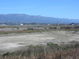
The Goleta Slough is an area of estuary, tidal creeks, tidal marsh, and wetlands near Goleta, California, United States. It primarily consists of the filled and unfilled remnants of the historic inner Goleta Bay about 8 miles (13 km) west of Santa Barbara. The slough empties into the Pacific Ocean through an intermittently closed mouth at Goleta Beach County Park just east of the UCSB campus and Isla Vista. The slough drains the Goleta Valley and watershed, and receives the water of all of the major creeks in the Goleta area including the southern face of the Santa Ynez Mountains.
Kelsey Creek is a creek in Bellevue, Washington on Seattle's Eastside. Originating in the wetlands in the Lake Hills greenbelt between Phantom Lake and Larsen Lake, it flows north and west through the Crossroads neighborhood and then south to Kelsey Creek Park where it turns west and becomes the Mercer Slough just west of Interstate 405. The centerpiece of the largest wetland adjacent to Lake Washington at 367 acres (149 ha), the slough empties into the East Channel of Lake Washington at Interstate 90.

New Brunswick is one of Canada's three Maritime provinces. While New Brunswick is one of Canada's Maritime Provinces, it differs from its neighbours both ethnoculturally and physiographically. Both Nova Scotia and Prince Edward Island are either wholly or nearly surrounded by water and the ocean, therefore, tends to define their climate, economy and culture. New Brunswick, on the other hand, although having a significant seacoast, is sheltered from the Atlantic Ocean proper and has a large interior that is removed from oceanic effects. New Brunswick, therefore, tends to be defined by its rivers rather than its seacoast.

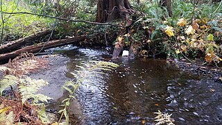
Still Creek is a long stream flowing across Central Burnaby, British Columbia and into Burnaby Lake. Still Creek's path lies mainly through the industrial area which contributes to its high level of pollution, although through dedicated work of local volunteers the creek is slowly recovering.

The geography of New York state varies widely. Most of New York is dominated by farms, forests, rivers, mountains, and lakes. New York's Adirondack Park is larger than any U.S. National Park in the contiguous United States. Niagara Falls, on the Niagara River as it flows from Lake Erie to Lake Ontario, is a popular attraction. The Hudson River begins near Lake Tear of the Clouds and flows south through the eastern part of the state without draining lakes George or Champlain. Lake George empties at its north end into Lake Champlain, whose northern end extends into Canada, where it drains into the Richelieu River and then the St. Lawrence. Four of New York City's five boroughs are on the three islands at the mouth of the Hudson River: Manhattan Island, Staten Island, and Brooklyn and Queens on Long Island.
The Toronto ravine system is a distinctive feature of the city's geography, consisting of a network of deep ravines which forms a large urban forest that runs through most of Toronto. The ravine system is the largest in any city in the world, with the Ravine and Natural Feature Protection Bylaw protecting approximately 110 square kilometres (42 sq mi) of public and privately-owned land. The ravine system has been presented as a central characteristic of the city, with the size of the ravine system leading Toronto to be described as "a city within a park".

Mill Creek Ravine is located Edmonton, Alberta, Canada and is a part of the River Valley parks and trail system. It contains the last stretch of Mill Creek, before it flows into a culvert for its end run to the North Saskatchewan River. The ravine ends where the land opens onto the North Saskatchewan River valley near the west end of Cloverdale on the opposite bank from downtown.

Lansdowne is a neighbourhood in south west Edmonton, Alberta, Canada overlooking the Whitemud Creek Ravine. The Snow Valley Ski Hill is located near the neighbourhood. The neighbourhood is situated directly across from Michener Park, a residential complex for students staying at the University of Alberta.

Whitemud Creek is a tributary of the North Saskatchewan River in central Alberta, Canada.

The North Saskatchewan River valley parks system, also known as the Ribbon of Green or the River Valley Parks, is a continuous collection of urban parks around the North Saskatchewan River valley in the Edmonton Metropolitan Region of Alberta, Canada. The park system encompasses over 7,300 hectares of parkland, making it the largest contiguous area of urban parkland in the country. The park system is made up of over 30 provincial and municipal parks situated around the river from Devon to Fort Saskatchewan, with trails connecting most of the parks together.

The Schussen is a 59-kilometre-long (37 mi) tributary of the Bodensee, which drains to the Rhine, in the southern portion of Upper Swabia in Baden-Württemberg (Germany).
Rat Creek is a tributary to the North Saskatchewan River. Rat Creek was once part of a much larger system which formerly almost connected to the Sturgeon River. However, Rat Creek is now defined as a lost creek, due to the city of Edmonton's encroachment on the surrounding area for urban use. Rat Creek was fed by sloughs that occurred north of Edmonton.
Fulton Creek is a minor tributary which flows into the North Saskatchewan River. Fulton Creek originates within The Meadows area of Edmonton, Alberta. As with other urban Edmonton waterways, with long stretches running through underground culverts, and water volume managed by other urban land uses and for erosion control, Fulton Creek has been labeled a lost creek.

The Toronto waterway system comprises a series of natural and man-made watercourses in the Canadian city of Toronto. The city is dominated by a large river system spanning most of the city including the Don River, Etobicoke Creek, Highland Creek, Humber River, Mimico Creek and Rouge River.

Yellow Creek, is a partially buried south-easterly tributary of the Don River in Toronto. It has also been known at different times as Silver Creek, Sylvan Creek, and also Rosedale Brook. The former source of Yellow Creek begins near Sheppard West station in the Downsview neighbourhood. Most of the creek and its sources are buried underground in storm sewers until they emerge into Avoca Ravine in the Deer Park neighbourhood and continues its way to the Don River.
