Ram River

Last updated
Ram River
CountryFlag of Alberta.svg  Alberta Flag of Canada.svg  Canada
Physical characteristics
Main source Ram River Glacier
2,374 m (7,789 ft)
51°53′19″N116°10′59″W / 51.88861°N 116.18306°W / 51.88861; -116.18306
River mouth North Saskatchewan River
1,048 m (3,438 ft)
52°22′32″N115°24′06″W / 52.37556°N 115.40167°W / 52.37556; -115.40167 Coordinates: 52°22′32″N115°24′06″W / 52.37556°N 115.40167°W / 52.37556; -115.40167

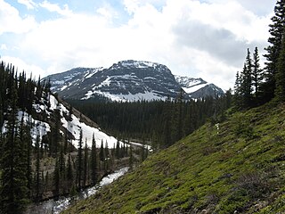
The Ram River is a river rising in the Alberta Rocky Mountains. It flows eastward, taking on the North Ram River, before joining the North Saskatchewan River near the Town of Rocky Mountain House. The name Ram Rivulet appears on a David Thompson map of 1814. A ram is a male Rocky Mountain Sheep. [1]

Alberta Province of Canada

Alberta is a western province of Canada. With an estimated population of 4,067,175 as of 2016 census, it is Canada's fourth most populous province and the most populous of Canada's three prairie provinces. Its area is about 660,000 square kilometres (250,000 sq mi). Alberta and its neighbour Saskatchewan were districts of the Northwest Territories until they were established as provinces on September 1, 1905. The premier is Jason Kenney as of April 30, 2019.

Rocky Mountains mountain range in North America

The Rocky Mountains, also known as the Rockies, are a major mountain range in western North America. The Rocky Mountains stretch more than 4,800 kilometers (3,000 mi) from the northernmost part of British Columbia, in western Canada, to New Mexico in the Southwestern United States. Located within the North American Cordillera, the Rockies are somewhat distinct from the Pacific Coast Ranges, Cascade Range, and the Sierra Nevada, which all lie farther to the west.

North Saskatchewan River river in Alberta and Saskatchewan

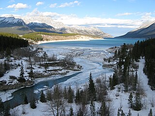
The North Saskatchewan River is a glacier-fed river that flows from the Canadian Rockies continental divide east to central Saskatchewan, where it joins with another major river to make up the Saskatchewan River. Its water flows eventually into the Hudson Bay.

Contents

The Ram River is characterized by numerous waterfalls and deep canyons throughout its course. It is first bridged by Alberta Highway 734, and again by a secondary road above its confluence with the North Saskatchewan River. Ram Falls Provincial Recreation Area is also located on the river.

Alberta Highway 734 highway in Alberta

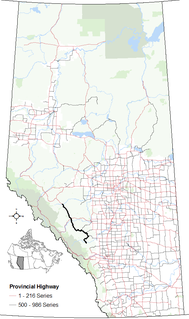
Alberta Provincial Highway No. 734, commonly referred to as Highway 734, is a highway in western Alberta, Canada that travels through the forested foothills of the Rocky Mountains. It used to be part of Forestry Trunk Road and is still colloquially referred to as such.

Confluence Meeting of two or more bodies of flowing water

In geography, a confluence occurs where two or more flowing bodies of water join together to form a single channel. A confluence can occur in several configurations: at the point where a tributary joins a larger river ; or where two streams meet to become the source of a river of a new name ; or where two separated channels of a river rejoin at the downstream end.

Ram Falls Provincial Park provincial park of Alberta

Ram Falls Provincial Park is a provincial park in Alberta, Canada, located 64 km (40 mi) south of Nordegg and 95 km (59 mi) west of Rocky Mountain House on Highway 734.

Tributaries

See also

Related Research Articles

South Saskatchewan River river in Alberta and Saskatchewan

The South Saskatchewan River is a major river in Canada that flows through the provinces of Alberta and Saskatchewan.

Geography of Alberta

Alberta is a Canadian province. Located in Western Canada, the province has an area of 661,190 square kilometres (255,290 sq mi) and is bounded to the south by the U.S. state of Montana along 49° north for 298 kilometres (185 mi); to the east at 110° west by the province of Saskatchewan for 1,223 kilometres (760 mi); and at 60° north the Northwest Territories for 644 kilometres (400 mi). The southern half of the province borders British Columbia along the Continental Divide of the Americas on the peaks of the Rocky Mountains, while the northern half borders British Columbia along the 120th meridian west.

The Oldman River is a river in southern Alberta, Canada. It flows roughly west to east from the Rocky Mountains, through the communities of Fort Macleod, Lethbridge, and on to Grassy Lake, where it joins with the Bow River to form the South Saskatchewan River, which eventually drains into the Hudson Bay.

Clearwater River (Alberta) river in Alberta, Canada

Clearwater is a river of southern Alberta, Canada. Situated entirely in the Canadian Rockies and the Rocky Mountain foothills of Alberta, it is a glacier fed upper reach tributary of the North Saskatchewan River. The upper reach of the Clearwater has become popular for equestrian travelers due to the natural setting along the river.

Elbow River river in Canada

The Elbow River is a river in southern Alberta, Canada. It flows from the Canadian Rockies to the city of Calgary, where it merges into the Bow River.

Red Deer River river in Alberta, Canada

The Red Deer River is a river in Alberta and a small portion of Saskatchewan, Canada. It is a major tributary of the South Saskatchewan River and is part of the larger Saskatchewan-Nelson system that empties into Hudson Bay.

Scouting and Guiding in Alberta

Scouting and Guiding in Alberta has a long history, from the 1900s to the present day, serving thousands of youth in programs that suit the environment in which they live.

Smoky River river in Canada

The Smoky River is a river in western Alberta, Canada. It is a major tributary of the Peace River. The descriptive name refers to the presence of "smouldering beds of coal in the riverbank" noted by the Cree Indians.

Abraham Lake lake in Alberta, Canada

Abraham Lake, also known as Lake Abraham, is an artificial lake and Alberta's largest reservoir. It is located in the "Kootenay Plains area of the Canadian Rockies' front range", on the North Saskatchewan River in western Alberta, Canada.

Brazeau River river in Alberta, Canada

The Brazeau River is a river in western Alberta, Canada. It is a major tributary of the North Saskatchewan River.

Ghost River Wilderness Area

The Ghost River Wilderness Area is a provincially designated wilderness area in the Canadian Rockies of Alberta. It was established in 1967 and it, as one of the three Wilderness Areas of Alberta, has the strictest form of government protection available in Canada. All development is forbidden and only travel by foot is permitted. Hunting and fishing are not allowed. The other two Wilderness Areas are White Goat Wilderness Area and Siffleur Wilderness Area and together the three areas total 249,548.80 acres (100,988.82 ha).

Central Alberta region in the province of Alberta, Canada

Central Alberta is a region located in the Canadian province of Alberta.

Albertas Rockies

Alberta's Rockies comprises the Canadian Rockies in the province of Alberta, Canada. It is a region on the southwestern part of the province, along the British Columbia border. It covers all but the south of Census Division 15.

Cardinal River river in Canada

Cardinal River is a short river in western Alberta, Canada. It flows from the Canadian Rockies, and empties into the Brazeau River, itself a major tributary of the North Saskatchewan River.

Siffleur River river in Canada

The Siffleur River is a short river rising in the Canadian Rockies in western Alberta. The Siffleur River is an early tributary of the North Saskatchewan River.

Nigel Creek river in Canada

Nigel Creek is a short stream located in the Canadian Rockies of Alberta, Canada. It forms in the glacial meltwaters north of Sunwapta Pass and takes on streams flowing from Nigel Pass.

Cline River river in Canada

The Cline River is a short river in western Alberta, Canada. It flows from Pinto Lake and joins the North Saskatchewan River at Lake Abraham in west-central Alberta.

The Jackpine River is an early tributary of the Smoky River. It forms in the Canadian Rockies, within Willmore Wilderness Park, in the province of Alberta, north of Jasper National Park. The river collects the runoff from Resthaven Mountain, Barricade Mountain, Jackpine Mountain, Mount Holmes, Perseverance Mountain, and Draco Peak.

Medicine River (Alberta) watercourse in Canada

The Medicine River is a medium-sized river in central Alberta. It begins at the outlet of Medicine Lake, north of Rocky Mountain House. The Medicine River initially travels through the Rocky Mountain House Grazing Reserve, a protected area with over 15,000 acres (61 km2) of land set aside for cattle grazing and recreation. The river flows southwest, taking on a number of creeks before passing Eckville. The Medicine River joins the Red Deer River north of Innisfail, downstream of the Dickson Dam, at the Medicine Flats. The Medicine is bridged by Alberta highways 53, 12, 11, and 54.

References

  1. Karamitsanis, Aphrodite. Place Names of Alberta, Volume 1. (Calgary: University of Calgary Press, 1991) pg. 203.