
The South Saskatchewan River is a major river in the Canadian provinces of Alberta and Saskatchewan. The river begins at the confluence of the Bow and Oldman Rivers in southern Alberta and ends at the Saskatchewan River Forks in central Saskatchewan. The Saskatchewan River Forks is the confluence of the South and North Saskatchewan Rivers and is the beginning of the Saskatchewan River.

Mount Brazeau is a mountain in Alberta, Canada.

The Oldman River is a river in southern Alberta, Canada. It flows roughly west to east from the Rocky Mountains, through the communities of Fort Macleod, Lethbridge, and on to Grassy Lake, where it joins the Bow River to form the South Saskatchewan River, which eventually drains into the Hudson Bay.

Fish Creek Park is an urban provincial park that preserves the valley of Fish Creek in the southern part of Calgary, Alberta, Canada. It is bordered on three sides by the city, and on the west by the territory of the Tsuu T’ina Nation (Sarcee), a First Nation.
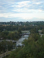
The Elbow River is a river in southern Alberta, Canada. It flows from the Canadian Rockies to the city of Calgary, where it merges into the Bow River.

The Red Deer River is a river in Alberta and a small portion of Saskatchewan, Canada. It is a major tributary of the South Saskatchewan River and is part of the larger Saskatchewan / Nelson system that empties into Hudson Bay.
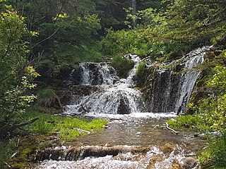
Big Hill Springs Provincial Park is a provincial park in the foothills of Alberta's Rocky Mountains, about 40 kilometres (20 mi) northwest of Calgary, Alberta, Canada. It features a series of springs and small waterfalls that flow year-round over rocky terraces covered with a lush growth of mosses, shrubs, and grasses. The park also includes the ruins of a historic fish hatchery and Alberta's first commercial creamery. The main activities at the park are hiking, picnicking, scenic viewing, wildlife watching, and photography.

Nordegg is a hamlet in west-central Alberta, Canada within Clearwater County. It is in the North Saskatchewan River valley in the foothills of the Canadian Rockies, just east of the intersection of the David Thompson Highway and the Highway 734 spur of the Bighorn Highway. A former coal mining town, it was named after Martin Nordegg and the name probably means "North Corner" in a German dialect. The railway station name at the locality was called Brazeau rather than Nordegg at certain points in its history, but the local post office has always been named Nordegg. The name Brazeau is now obsolete.

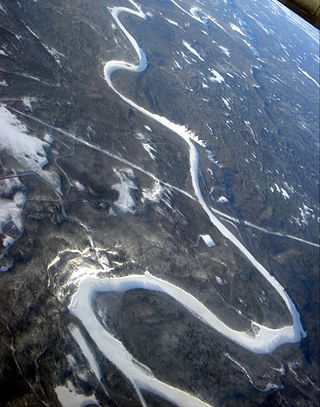
The North Saskatchewan River is a glacier-fed river that flows from the Canadian Rockies continental divide east to central Saskatchewan, where it joins with the South Saskatchewan River to make up the Saskatchewan River. Its water flows eventually into the Hudson Bay.
The Smoky River is a river in western Alberta, Canada. It is a major tributary of the Peace River. The name refers to the presence of "smouldering beds of coal in the riverbank" noted by the Cree people, an Indigenous people of the area.

The Brazeau River is a river in western Alberta, Canada. It is a major tributary of the North Saskatchewan River.
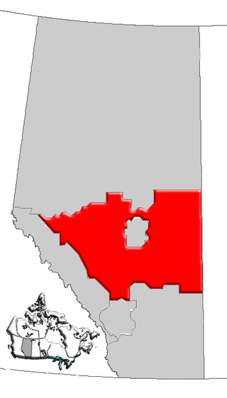
Central Alberta is a region located in the Canadian province of Alberta.
Blackstone River is a medium-sized river originating in the front ranges of the Canadian Rockies. It is a tributary of the Brazeau River, which in turn flows into the North Saskatchewan River.
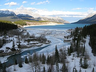
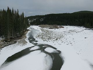
The Cline River is a short river in western Alberta, Canada. It flows from Pinto Lake and joins the North Saskatchewan River at Lake Abraham in west-central Alberta.

The Smoky Group is a stratigraphical unit of Late Cretaceous age in the Western Canadian Sedimentary Basin.

The Muskiki Formation is a stratigraphical unit of Late Cretaceous age in the Western Canadian Sedimentary Basin.
The Alberta Coal Branch is the name given to a segment of the Canadian National Railway and the region through which it passes. It is located within Yellowhead County in west-central Alberta, Canada.

Saunders Creek is a ghost town in west-central Alberta, Canada. Built as a coal mining community, the town existed from 1913 to 1954. It is located in the foothills of the Canadian Rockies near the David Thompson Highway, about 55 km west of the town of Rocky Mountain House. It was named for Saunders Creek, a small stream that runs immediately west of the townsite. The North Saskatchewan River flows nearby to the south.
Brazeau Canyon Wildland Provincial Park is a wildland provincial park in Yellowhead County, central Alberta, Canada. The park has an area of 5,039.32 hectares and was created on 20 December 2000. The park is named for the valley in which flows the Brazeau River.


