The Lac La Ronge Indian Band is a Woodland Cree First Nation in northern Saskatchewan, it is the largest Cree band government in Canada and the largest First Nation in Saskatchewan. The administrative centre of the Lac La Ronge Indian Band is located in La Ronge.
Makaoo 120 is an Indian reserve of the Onion Lake Cree Nation in Alberta and Saskatchewan, located between the County of Vermilion River and the Rural Municipality of Frenchman Butte No. 501. It is 42 kilometres north of Lloydminster. In the 2016 Canadian Census, it recorded a population of 726 living in 165 of its 179 total private dwellings.

Chicken 224 is an Indian reserve of the Black Lake Denesuline First Nation in Saskatchewan. It is 170 kilometres southeast of Uranium City. In the 2016 Canadian Census, it recorded a population of 1379 living in 263 of its 280 total private dwellings. In the same year, its Community Well-Being index was calculated at 42 of 100, compared to 58.4 for the average First Nations community and 77.5 for the average non-Indigenous community.

Chicken 225 is an Indian reserve of the Black Lake Denesuline First Nation in Saskatchewan. In the 2016 Canadian Census, it recorded a population of 0 living in 0 of its 0 total private dwellings.

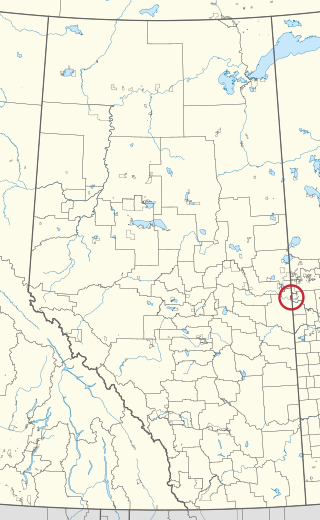
The Chief Joseph Custer Reserve is an Indian reserve of the Peter Ballantyne Cree Nation in Saskatchewan. It is located in the city of Prince Albert, making it an urban reserve.

Chief Philip Morin 232 is an Indian reserve of the Peter Ballantyne Cree Nation in Saskatchewan. It is located inside the city of Prince Albert, making it an urban reserve.

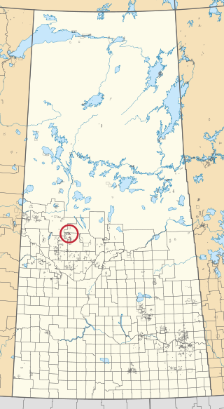
Little Hills 158B is an Indian reserve of the Lac La Ronge Indian Band in Saskatchewan. It is 8 miles southwest of La Ronge, and on the south-east shore of Bigstone Lake.

Little Red River 106C is an Indian reserve of the Lac La Ronge Indian Band in Saskatchewan. It is 34 kilometres north of Prince Albert. In the 2016 Canadian Census, it recorded a population of 354 living in 88 of its 98 total private dwellings. In the same year, its Community Well-Being index was calculated at 48 of 100, compared to 58.4 for the average First Nations community and 77.5 for the average non-Indigenous community.

Makwa Lake 129B is an Indian reserve of the Makwa Sahgaiehcan First Nation in Saskatchewan. It is 95 miles northwest of North Battleford. In the 2016 Canadian Census, it recorded a population of 982 living in 226 of its 444 total private dwellings. In the same year, its Community Well-Being index was calculated at 47 of 100, compared to 58.4 for the average First Nations community and 77.5 for the average non-Indigenous community.
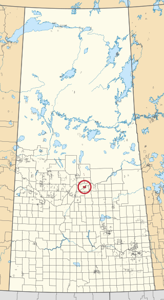
Montreal Lake 106 is an Indian reserve of the Montreal Lake Cree Nation in Saskatchewan. It is 93 kilometres north of Prince Albert.

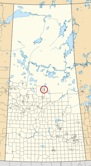
Morin Lake 217 is an Indian reserve of the Lac La Ronge Indian Band in Saskatchewan. It is 24 kilometres east of Lac la Ronge. In the 2016 Canadian Census, it recorded a population of 577 living in 135 of its 155 total private dwellings. In the same year, its Community Well-Being index was calculated at 45 of 100, compared to 58.4 for the average First Nations community and 77.5 for the average non-Indigenous community.

Muskeg Lake 102B is an Indian reserve of the Muskeg Lake Cree Nation in Saskatchewan. It is 67 kilometres northeast of North Battleford. In the 2016 Canadian Census, it recorded a population of 0 living in 0 of its 0 total private dwellings.

Muskeg Lake 102D is an Indian reserve of the Muskeg Lake Cree Nation in Saskatchewan. It is 43 kilometres southwest of Shellbrook. In the 2016 Canadian Census, it recorded a population of 0 living in 0 of its 0 total private dwellings.

Muskeg Lake 102E is an Indian reserve of the Muskeg Lake Cree Nation in Saskatchewan. It is 49 kilometres south of Shellbrook. In the 2016 Canadian Census, it recorded a population of 0 living in 0 of its 0 total private dwellings.

Muskeg Lake 102F is an Indian reserve of the Muskeg Lake Cree Nation in Saskatchewan. It is 41 kilometres southwest of Shellbrook. In the 2016 Canadian Census, it recorded a population of 20 living in 8 of its 8 total private dwellings.
The Muskoday Reserve is an Indian reserve of the Muskoday First Nation in Saskatchewan. It is 19 kilometres southeast of Prince Albert. In the 2016 Canadian Census, it recorded a population of 647 living in 205 of its 217 total private dwellings. In the same year, its Community Well-Being index was calculated at 64 of 100, compared to 58.4 for the average First Nations community and 77.5 for the average non-Indigenous community.

Pelican Lake 191A is an Indian reserve of the Pelican Lake First Nation in Saskatchewan. It is 66 kilometres southeast of Meadow Lake. In the 2016 Canadian Census, it recorded a population of 20 living in 3 of its 6 total private dwellings.
Pelican Lake 191B is an Indian reserve of the Pelican Lake First Nation in Saskatchewan. It is 14 kilometres west of Leoville. In the 2016 Canadian Census, it recorded a population of 50 living in 11 of its 19 total private dwellings.

Saulteaux 159A is an Indian reserve of the Saulteaux First Nation in Saskatchewan. It is 48 miles north of North Battleford, on the north shore of Birch Lake and east shore of Helene Lake. In the 2016 Canadian Census, it recorded a population of 26 living in 7 of its 10 total private dwellings.

Wahpaton 94A is an Indian reserve of the Wahpeton Dakota Nation in Saskatchewan. It is 10 kilometres north of Prince Albert. In the 2016 Canadian Census, it recorded a population of 309 living in 70 of its 80 total private dwellings. In the same year, its Community Well-Being index was calculated at 58 of 100, compared to 58.4 for the average First Nations community and 77.5 for the average non-Indigenous community.

