Fillmore, Saskatchewan

Last updated

Fillmore
Village of Fillmore
Fillmore 02 downtown.jpg
Downtown Fillmore
Canada Saskatchewan location map.svg
Red pog.svg
Location of Fillmore in Saskatchewan
Canada location map 2.svg
Red pog.svg
Fillmore, Saskatchewan (Canada)
Coordinates: 49°52′41″N103°25′34″W / 49.878°N 103.426°W / 49.878; -103.426
Country Flag of Canada (Pantone).svg  Canada
Province Flag of Saskatchewan.svg  Saskatchewan
Region South-east
Census division 2
Rural Municipality Fillmore
Government
  Governing bodyFillmore Village Council
   Mayor Marvin Chambers
   Administrator Angela Lubiens
Area
  Total1.33 km2 (0.51 sq mi)
Population
 (2016)
  Total311
  Density234.7/km2 (608/sq mi)
Time zone UTC-6 (CST)
Postal code
S0G 1N0
Area code 306
Highways Saskatchewan Highway 33 (jct).svg Highway 33
Saskatchewan Rural Municipal Route.svg
Saskatchewan Route 606.svg
Highway 606
[1] [2] [3] [4]

Fillmore (2016 population: 311) is a village in the Canadian province of Saskatchewan within the Rural Municipality of Fillmore No. 96 and Census Division No. 2.

Contents

Grain elevator in Fillmore Fillmore grain elevator.jpg
Grain elevator in Fillmore

History

Fillmore incorporated as a village on June 10, 1905. [5]

Demographics

Population history
(1981–2016)
YearPop.±%
1981396    
1986350−11.6%
1991328−6.3%
1996 286−12.8%
2001 246−14.0%
2006 193−21.5%
2011 255+32.1%
2016 311+22.0%
Source: Statistics Canada via Saskatchewan Bureau of Statistics [6] [7]

In the 2021 Census of Population conducted by Statistics Canada, Fillmore had a population of 282 living in 123 of its 149 total private dwellings, a change of

In the 2016 Census of Population, the Village of Fillmore recorded a population of 311 living in 129 of its 149 total private dwellings, a

See also

Related Research Articles

Atwater is a village in the Canadian province of Saskatchewan within the Rural Municipality of Fertile Belt No. 183 and Census Division No. 5. The village is approximately 45 kilometres (28 mi) southeast of the city of Melville on Highway 629.

<span class="mw-page-title-main">Rural Municipality of Fillmore No. 96</span> Rural municipality in Saskatchewan, Canada

The Rural Municipality of Fillmore No. 96 is a rural municipality (RM) in the Canadian province of Saskatchewan within Census Division No. 2 and SARM Division No. 1. It is located in the south-east portion of the province along Highway 33.

<span class="mw-page-title-main">Maryfield, Saskatchewan</span> Village in Saskatchewan, Canada

Maryfield is a village in the Canadian province of Saskatchewan within the Rural Municipality of Maryfield No. 91 and Census Division No. 1. The village lies south of the intersection of Highway 48 and Highway 600 and is about 8 kilometres (5.0 mi) west of the Manitoba border. It is a junction point on the Canadian National Railway between the main line heading northwest towards Regina and a branch line heading southwest toward Carlyle and Lampman.

<span class="mw-page-title-main">Creelman, Saskatchewan</span> Village in Saskatchewan, Canada

Creelman is a village in the Canadian province of Saskatchewan within the RM of Fillmore No. 96 and Census Division No. 2. The village lies 118 km southeast of the city of Regina, on Highway 33.

Fosston is a village in the Canadian province of Saskatchewan within the Rural Municipality of Ponass Lake No. 367 and Census Division No. 14. The village was named after Fosston, Minnesota, the original home of five Rustad brothers, who homesteaded there.

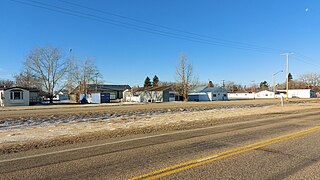
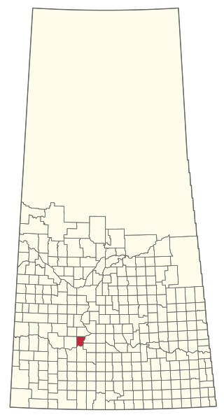
Hubbard is a village in the Canadian province of Saskatchewan within the Rural Municipality of Ituna Bon Accord No. 246 and Census Division No. 10.

Webb is a village in the Canadian province of Saskatchewan within the Rural Municipality of Webb No. 138 and Census Division No. 8.

<span class="mw-page-title-main">Viscount, Saskatchewan</span> Village in Saskatchewan, Canada

Viscount is a village in the Canadian province of Saskatchewan within the Rural Municipality of Viscount No. 341 and Census Division No. 11. Viscount is located on Saskatchewan Highway 16, the Yellowhead Highway, in central Saskatchewan east of Colonsay and west of Lanigan. As of the Canada 2016 Census, Viscount had a population of 232.

<span class="mw-page-title-main">Rural Municipality of Usborne No. 310</span> Rural municipality in Saskatchewan, Canada

The Rural Municipality of Usborne No. 310 is a rural municipality (RM) in the Canadian province of Saskatchewan within Census Division No. 11 and SARM Division No. 5. It is located in the central portion of the province.

<span class="mw-page-title-main">Rural Municipality of Orkney No. 244</span> Rural municipality in Saskatchewan, Canada

The Rural Municipality of Orkney No. 244 is a rural municipality (RM) in the Canadian province of Saskatchewan within Census Division No. 9 and SARM Division No. 4. It is located in the southeast portion of the province.

Waseca is a village in the Canadian province of Saskatchewan within the Rural Municipality of Eldon No. 471 and Census Division No. 17. Waseca is located on Highway 16, the Yellowhead Highway, in northwest Saskatchewan. Waseca is located east of Lashburn and west of Maidstone.

Rhein is a village in the Canadian province of Saskatchewan within the Rural Municipality of Wallace No. 243 and Census Division No. 9.

Osage is a village in the Canadian province of Saskatchewan within the Rural Municipality of Fillmore No. 96 and Census Division No. 2. The village is located on Highway 33, that runs south-east from Regina to Stoughton. The village has a grain elevator, post office, service station, and a two-sheet natural ice curling rink. Children from the area attend school in Fillmore, 13 km away. Osage celebrated its centennial in 2006.

<span class="mw-page-title-main">Rural Municipality of Calder No. 241</span> Rural municipality in Saskatchewan, Canada

The Rural Municipality of Calder No. 241 is a rural municipality (RM) in the Canadian province of Saskatchewan within Census Division No. 9 and SARM Division No. 4.

<span class="mw-page-title-main">Rural Municipality of Canaan No. 225</span> Rural Municipality in Saskatchewan, Canada

The Rural Municipality of Canaan No. 225 is a rural municipality (RM) in the Canadian province of Saskatchewan within Census Division No. 7 and SARM Division No. 3.

<span class="mw-page-title-main">Rural Municipality of Emerald No. 277</span> Rural municipality in Saskatchewan, Canada

The Rural Municipality of Emerald No. 277 is a rural municipality (RM) in the Canadian province of Saskatchewan within Census Division No. 10 and SARM Division No. 4.

<span class="mw-page-title-main">Rural Municipality of Harris No. 316</span> Rural municipality in Saskatchewan, Canada

The Rural Municipality of Harris No. 316 is a rural municipality (RM) in the Canadian province of Saskatchewan within Census Division No. 12 and SARM Division No. 5.

<span class="mw-page-title-main">Rural Municipality of Rudy No. 284</span> Rural municipality in Saskatchewan, Canada

The Rural Municipality of Rudy No. 284 is a rural municipality (RM) in the Canadian province of Saskatchewan within Census Division No. 11 and SARM Division No. 5.

<span class="mw-page-title-main">Rural Municipality of Livingston No. 331</span> Rural municipality in Saskatchewan, Canada

The Rural Municipality of Livingston No. 331 is a rural municipality (RM) in the Canadian province of Saskatchewan within Census Division No. 9 and SARM Division No. 4.

<span class="mw-page-title-main">Rural Municipality of Parkdale No. 498</span> Rural municipality in Saskatchewan, Canada

The Rural Municipality of Parkdale No. 498 is a rural municipality (RM) in the Canadian province of Saskatchewan within Census Division No. 17 and SARM Division No. 6.

References

  1. National Archives, Archivia Net, Post Offices and Postmasters, archived from the original on 6 October 2006
  2. Government of Saskatchewan, MRD Home, Municipal Directory System, archived from the original on 21 November 2008
  3. Canadian Textiles Institute. (2005), CTI Determine your provincial constituency, archived from the original on 11 September 2007
  4. Commissioner of Canada Elections, Chief Electoral Officer of Canada (2005), Elections Canada On-line, archived from the original on 21 April 2007
  5. "Urban Municipality Incorporations". Saskatchewan Ministry of Government Relations. Archived from the original on 15 October 2014. Retrieved 1 June 2020.
  6. "Saskatchewan Census Population" (PDF). Saskatchewan Bureau of Statistics. Archived from the original (PDF) on 24 September 2015. Retrieved 31 May 2020.
  7. "Saskatchewan Census Population". Saskatchewan Bureau of Statistics. Retrieved 31 May 2020.
  8. "Population and dwelling counts: Canada, provinces and territories, census divisions and census subdivisions (municipalities), Saskatchewan". Statistics Canada. 9 February 2022. Retrieved 1 April 2022.
  9. "Population and dwelling counts, for Canada, provinces and territories, and census subdivisions (municipalities), 2016 and 2011 censuses – 100% data (Saskatchewan)". Statistics Canada. 8 February 2017. Retrieved 30 May 2020.

Commons-logo.svg Media related to Fillmore, Saskatchewan at Wikimedia Commons