
Aneroid is a special service area in the Rural Municipality of Auvergne No. 76 in southwestern Saskatchewan, Canada. The community is located approximately 70 km southeast of Swift Current at the intersection of Highway 13 and Highway 612.
Cedoux is an unincorporated community in the Rural Municipality of Wellington No. 97 in the province of Saskatchewan, Canada. It held village status prior to July 21, 1913. Cedoux is located on Highway 35, approximately 25 kilometres (16 mi) north of the city of Weyburn and approximately 91 kilometres (57 mi) southeast of Regina.
Bounty is an unincorporated community in Fertile Valley No. 285 Saskatchewan, Canada. The population was 5 at the 2001 Census. It previously held the status of village until November 25, 1997. The community is located on Range Road 104 and Township Road 300, about 21 kilometres (13 mi) west of Outlook. At one time Bounty was said to have nobody living in the community.

Vidora is an unincorporated community within the Rural Municipality of Reno No. 51, Saskatchewan, Canada. The community once had a population of 200 people in 1940 and has since declined to 1 resident. It previously held village status until it was dissolved as an unincorporated community on January 1, 1952. The community is located between Robsart and Consul on Highway 21 and Highway 13, known as the Red Coat Trail. Very little remains of the former village, only one home that is also used as a post office still stands as of 2008. There are many cement foundations and sidewalks still found scattered around the town site, including the remnants of the old bank vault to the former Municipality Office that was moved to Consul.
McTaggart is a village in the Canadian province of Saskatchewan within the Rural Municipality of Weyburn No. 67 and Census Division No. 2.

Scotsguard is an unincorporated community within the Rural Municipality of Bone Creek No. 108, Saskatchewan, Canada. The community is located on Highway 13, also known as the historic Red Coat Trail, about 10 km northeast of the town of Shaunavon.
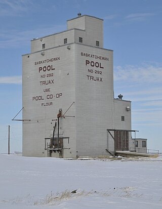
Truax is an unincorporated community in the Rural Municipality of Elmsthorpe No. 100, Saskatchewan, Canada. It held village status prior to December 30, 1970. Truax is located 80 km (50 mi) southwest of Regina and approximately 75 km (47 mi) southeast of Moose Jaw.

The Rural Municipality of Lake Alma No. 8 is a rural municipality (RM) in the Canadian province of Saskatchewan within Census Division No. 2 and SARM Division No. 2. Located in the southeast portion of the province, it is adjacent to the United States border, neighbouring Sheridan County in Montana and Divide County in North Dakota.
Spring Valley is a hamlet in Terrell Rural Municipality No. 101 in the province of Saskatchewan, Canada. Located at the end of highway 715, and approximately 62 km south of the city of Moose Jaw.
Ceylon is a village in the Canadian province of Saskatchewan within the Rural Municipality of The Gap No. 39 and Census Division No. 2. It is located alongside Gibson Creek, which is a tributary of Long Creek. No shops or businesses other than the bar remain.

The Rural Municipality of Moose Mountain No. 63 is a rural municipality (RM) in the Canadian province of Saskatchewan within Census Division No. 1 and SARM Division No. 1. It is located in the south-east portion of the province.
The Rural Municipality of Norton No. 69 is a rural municipality (RM) in the Canadian province of Saskatchewan within Census Division No. 2 and SARM Division No. 2. It is located in the southeast portion of the province.

Lemsford is an unincorporated hamlet in the Rural Municipality of Clinworth No. 230, Saskatchewan, Canada. It previously held the status of village until January 1, 1951. The hamlet is located 42 km east of the town of Leader at the intersection of Highway 32 and Highway 649. The hamlet is also serviced by the Great Western Railway.
Palmer is a small unorganized hamlet located 15 km east of the town of Gravelbourg in Sutton Rural Municipality No. 103, Saskatchewan, Canada. The population of Palmer fluctuates during the year, hovering in the double digits with peak population occurring in the summer months. The main reason of this spike is due to the efforts of the residents to establish Palmer as a venue for performing artists. In 2006 the hamlet had a population of 27 people. It previously held the status of village until January 1, 2002.

St. Victor, or Saint Victor, is a Fransaskois community in the Rural Municipality of Willow Bunch No. 42. In 2006, it had a population of 43 people. It previously held the status of village until February 26, 2003. St. Victor is located 37 km south of the town of Assiniboia 10 km east of Highway 2. St. Victor Petroglyphs Provincial Park is two kilometres south of the community.
Hardy is a hamlet in The Gap Rural Municipality No. 39, Saskatchewan, Canada. The community had a population of 5 in 2001. It previously held the status of village until January 1, 2000. The hamlet is located 82 km south west of the City of Weyburn 10 km west of highway 6 and 5 km north of highway 705. Hardy was named for the great 19th-century English novelist and poet Thomas Hardy.
Madison is an unincorporated community in Newcombe Rural Municipality No. 260, Saskatchewan, Canada. The community had a population of 10 in 2001. It previously held the status of village until February 1, 1998. The hamlet is located 20 km west of the Town of Eston on highway 44 along the Canadian National Railway subdivision.

Willows is an unincorporated community in Lake of the Rivers Rural Municipality No. 72, Saskatchewan, Canada. It previously held the status of a village until January 1, 1950. The name is a contraction of William Gibson Lowes, owner of the first store.
Woodley is an unincorporated community in Benson Rural Municipality No. 35, Saskatchewan, Canada. Woodley, like many other small communities throughout Saskatchewan, has struggled to maintain a steady population which made Woodley a ghost town.

