Related Research Articles

New Norway is a hamlet located in central Alberta, Canada within Camrose County. Named in 1895, it is located on Highway 21, approximately 100 km (62 mi) southeast of Edmonton and 22 km (14 mi) southwest of Camrose.

Treherne is an unincorporated urban community in the Municipality of Norfolk Treherne within the Canadian province of Manitoba that held town status prior to January 1, 2015. It is halfway between Winnipeg and Brandon on Provincial Highway 2. Primarily a farming community, Treherne has a significant portion of the municipality's population, which is around 1750 people, and has two schools and a hospital. There is also a daycare facility, and in 2006 Treherne opened the Treherne Aquatic Centre next to a campground facility.
Fort Assiniboine is a hamlet in northwest Alberta, Canada, within Woodlands County. It is located along the north shore of the Athabasca River at the junction of Highway 33 and Highway 661. It is approximately 39 kilometres (24 mi) northwest of Barrhead, 62 kilometres (39 mi) southeast of Swan Hills and 91 kilometres (57 mi) northeast of Whitecourt.

Donnelly is a village in northern Alberta, Canada within the Municipal District of Smoky River No. 130. It is located near the intersection of Highway 2 and Highway 49, located approximately 65 km (40 mi) south of Peace River and 427 km (265 mi) northwest of Edmonton.
Minburn is a hamlet in central, Alberta, Canada within the County of Minburn No. 27. It is located on the Yellowhead Highway and the Canadian National Railway, approximately 37 km (23 mi) west of the Town of Vermilion and 143 km (89 mi) east of the City of Edmonton.
Schuler is a hamlet in southern Alberta, Canada within Cypress County, located 4 kilometres (2.5 mi) east of Highway 41, approximately 40 kilometres (25 mi) northeast of Medicine Hat.
Turin is a hamlet in Alberta, Canada within the Lethbridge County. It is located approximately 56 kilometres (35 mi) northeast of Lethbridge on Highway 25 and along a Canadian Pacific Railway line.
Dickson is a hamlet in central Alberta, Canada within Red Deer County. It is located approximately 25 kilometres (16 mi) west of Innisfail near the Dickson Dam and Gleniffer Lake. It is within Census Division No. 8.
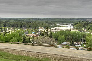
La Crete, also spelled La Crête, is a hamlet in northern Alberta, Canada, within Mackenzie County. It is located on Highway 697, approximately 57 kilometres (35 mi) southeast of High Level and 701 kilometres (436 mi) north of Edmonton.
Cheadle is a hamlet in Alberta, Canada within Wheatland County. It is located on Highway 24, 2 kilometers (1.2 mi) south of the Highway 1 and approximately 35 kilometers (22 mi) east of the City of Calgary.

Rosebud, Alberta is a hamlet in southern Alberta, Canada within Wheatland County. Previously an incorporated municipality, Rosebud dissolved from village status on January 1, 1946, to become part of the Municipal District of Grasswold No. 248.
Huxley is a hamlet in southern Alberta, Canada within Kneehill County. It is located approximately 160 km (99 mi) northeast of Calgary. The first school was built in 1907 and named Ashcroft for John Courtland Ash, the first rancher in the area, predating the surveying of the area into homesteads.
Calder is a village in the Canadian province of Saskatchewan within the Rural Municipality of Calder No. 241 and Census Division No. 9. The village lies approximately 56 km east of the City of Yorkton and 35 km west of Roblin, Manitoba, approximately 5 km south of Highway 8 and Highway 10.
Gleichen is a hamlet in southeast Alberta, Canada within Wheatland County. It is located adjacent to the Siksika Nation at the intersection of Highway 1 and Highway 547, approximately 40 kilometres (25 mi) southeast of Strathmore. It has an elevation of 903 m (2,963 ft).

Valhalla Centre is a hamlet in northern Alberta, Canada within the County of Grande Prairie No. 1.

Paynton is a village in the Canadian province of Saskatchewan within the Rural Municipality of Paynton No. 470 and Census Division No. 17.
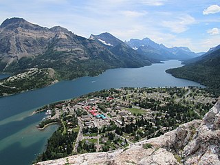
Waterton Park, commonly referred to as Waterton, is a hamlet in southwestern Alberta, Canada within Improvement District No. 4 Waterton.
Lisieux is an unincorporated community in the Rural Municipality of Willow Bunch No. 42, Saskatchewan, Canada. It was designated as an organized hamlet prior to 2018.
Tantallon is a village in the Canadian province of Saskatchewan within the Rural Municipality of Spy Hill No. 152 and Census Division No. 5. It is in the Qu'Appelle Valley along the Qu'Appelle River about 39 km east of Round Lake (Saskatchewan). The community celebrated its centennial in 2004.
The Rural Municipality of Willow Bunch No. 42 is a rural municipality (RM) in the Canadian province of Saskatchewan within Census Division No. 3 and SARM Division No. 2. It is located in the south central portion of the province.
References
- ↑ "Population and dwelling counts: Canada and designated places". Statistics Canada. February 9, 2022. Retrieved August 31, 2022.
49°43′33″N105°09′01″W / 49.72583°N 105.15028°W
| | This article about a location in the Census Division No. 2 of Saskatchewan is a stub. You can help Wikipedia by expanding it. |