Ridgedale is a village in the Canadian province of Saskatchewan within the Rural Municipality of Connaught No. 457 and Census Division No. 14.
Limerick is a village in the Canadian province of Saskatchewan within the Rural Municipality of Stonehenge No. 73 and Census Division No. 3. The village is about 150 km (94 mi) north of the US border near the towns of Lafleche and Gravelbourg. The village is named after the Irish city of Limerick.
Albertville is a village in the Canadian province of Saskatchewan within the Rural Municipality of Wise Creek No. 77 and Census Division No. 15. It is approximately 25 km northeast of the City of Prince Albert.

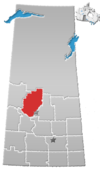
The Rural Municipality of Leask No. 464 is a rural municipality (RM) in the Canadian province of Saskatchewan within Census Division No. 16 and SARM Division No. 5. It is located west of the City of Prince Albert.
Chaplin is a village in the Canadian province of Saskatchewan within the Rural Municipality of Chaplin No. 164 and Census Division No. 7. The community is situated on the Trans-Canada Highway approximately 85 km from Moose Jaw and 90 km from Swift Current. The main industries of Chaplin are Saskatchewan Minerals and farming/ranching. Chaplin consists of eight streets, two crescents, and four avenues.
Debden is a village in the Canadian province of Saskatchewan within the Rural Municipality of Canwood No. 494 and Census Division No. 16. The village is located on Highway 55 and is 94 km from the City of Prince Albert and 194 km from the City of Saskatoon. It is also the administrative headquarters of the Big River Cree First Nations band government. The village is at the edge of the Prince Albert National Park and with all the lakes nearby it becomes a popular area in the summer months.
Coderre ) is a village in the Canadian province of Saskatchewan within the Rural Municipality of Rodgers No. 133 and Census Division No. 7. The village is located approximately 85 km southwest of the City of Moose Jaw on Highway 627.

Bradwell is a village in the Canadian province of Saskatchewan within the Rural Municipality of Blucher No. 343 and Census Division No. 11. The village is located about 36 km southeast of the City of Saskatoon on Highway 763. In 1936, during gravel excavations for a highway, the partial skeleton of a neolithic human male were discovered and named "Bradwell Man". A stone scraper and some eagle talons were found nearby.
Brownlee is a village in the Canadian province of Saskatchewan within the Rural Municipality of Eyebrow No. 193 and Census Division No. 7. The village is located approximately 58 km northwest of the City of Moose Jaw on Highway 42.
Buchanan is a village in the Canadian province of Saskatchewan within the Rural Municipality of Buchanan No. 304 and Census Division No. 9.

Elbow is a village in the Canadian province of Saskatchewan within the Rural Municipality of Loreburn No. 254 and Census Division No. 11. Elbow was founded in 1909, near what is now Lake Diefenbaker. It is 8 km northwest of Mistusinne, 10 km northwest of Douglas Provincial Park and 16 km southeast of Loreburn. The village got its name from its position on the elbow of the South Saskatchewan River.
Ernfold is a village in the Canadian province of Saskatchewan within the Rural Municipality of Morse No. 165 and Census Division No. 7. Initially situated alongside the original two-lane highway, the village was enclosed by the opposing lanes of the divided Trans-Canada Highway in 1973. In order to avoid complete destruction of the village the eastbound lane of the Trans-Canada Highway was rerouted approximately 3 km south of the village, leaving the village sandwiched between the Trans-Canada.

Glenside is a village in the Canadian province of Saskatchewan within the Rural Municipality of Rudy No. 284 and Census Division No. 11. The village is located on Highway 219 approximately 10 km east of the Town of Outlook.

Laird is a village in the Canadian province of Saskatchewan within the Rural Municipality of Laird No. 404 and Census Division No. 15. Laird is located in the Saskatchewan River Valley. The village is named after David Laird, Lieutenant Governor of the Northwest Territories.
McTaggart is a village in the Canadian province of Saskatchewan within the Rural Municipality of Weyburn No. 67 and Census Division No. 2.
Medstead is a village in the Canadian province of Saskatchewan within the Rural Municipality of Medstead No. 497 and Census Division No. 16.
Rush Lake is a village in the Canadian province of Saskatchewan within the Rural Municipality of Excelsior No. 166 and Census Division No. 7. Surrounding communities include Waldeck, Herbert, and the City of Swift Current.
Shamrock is a village in the Canadian province of Saskatchewan within the Rural Municipality of Shamrock No. 134 and Census Division No. 7.
Tugaske is a village in the Canadian province of Saskatchewan within the Rural Municipality of Huron No. 223 and Census Division No. 7. It is nicknamed Gateway to Lake Diefenbaker. It is near Eyebrow Lake, a prairie lake in the Qu'Appelle Valley. It was named after an eyebrow-shaped hill also in the Qu'Appelle Valley above Eyebrow Lake. The lake, which is 9 km long and 1 km wide, is a bird sanctuary and is near Highway 627.
Codette is a village in the Canadian province of Saskatchewan within the Rural Municipality of Nipawin No. 487 and Census Division No. 14. The village is located 10 km south of Nipawin at the junction of Highway 35 and Highway 789.