Pierceland

Last updated

Village of Pierceland
Village
Canada Saskatchewan relief location map.jpg
Red pog.svg
Village of Pierceland
Canada relief map 2.svg
Red pog.svg
Village of Pierceland
Coordinates: 54°20′56″N109°45′18″W / 54.349°N 109.755°W / 54.349; -109.755
Country Canada
Province Saskatchewan
Region Saskatchewan
Census division 17
Rural Municipality Beaver River
Post office Founded1932 April 01
Incorporated (Village)N/A
Incorporated (Town)N/A
Government
   Mayor Coral Dale
  AdministratorTammy Landry
  Council MemberCandace Frolick
  Council MemberJane Eistetter
  Council MemberShannon Wilton
Area
  Total
2.74 km2 (1.06 sq mi)
Population
 (2021)
  Total
605
  Density220.8/km2 (572/sq mi)
Time zone CST
Postal code
S0M 2K0
Area code 306
Highways Highway 21
Highway 55
Waterways Pierce Lake
Lac des Îles
Website Official website
[1] [2] [3] [4]

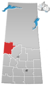
Pierceland (2016 population: 598) is a village in the Canadian province of Saskatchewan within the Rural Municipality of Beaver River No. 622 and Census Division No. 17. It is north of the Beaver River on Highway 55.
Contents

History

Pierceland incorporated as a village on January 1, 1973. [5]

Demographics

Population history
(1981–2016)
YearPop.±%
1981425    
1986501+17.9%
1991475−5.2%
1996 488+2.7%
2001 449−8.0%
2006 498+10.9%
2011 551+10.6%
2016 598+8.5%
Source: Statistics Canada via Saskatchewan Bureau of Statistics [6] [7]

In the 2021 Census of Population conducted by Statistics Canada, Pierceland had a population of 605 living in 251 of its 285 total private dwellings, a change of

In the 2016 Census of Population, the Village of Pierceland recorded a population of 598 living in 249 of its 289 total private dwellings, a

Notable people

See also

Related Research Articles

Marengo is a village in the Canadian province of Saskatchewan within the Rural Municipality of Milton No. 292 and Census Division No. 13. It is about 45 km (28 mi) west of Kindersley. It is located within the Sun West School Division.

<span class="mw-page-title-main">Rural Municipality of Dundurn No. 314</span> Rural municipality in Saskatchewan, Canada

The Rural Municipality of Dundurn No. 314 is a rural municipality (RM) in the Canadian province of Saskatchewan within Census Division No. 11 and SARM Division No. 5. It is located in the north-central portion of the province along the South Saskatchewan River and surrounds the Town of Dundurn.

<span class="mw-page-title-main">Rural Municipality of Excelsior No. 166</span> Rural municipality in Saskatchewan, Canada

The Rural Municipality of Excelsior No. 166 is a rural municipality (RM) in the Canadian province of Saskatchewan within Census Division No. 7 and SARM Division No. 3.

<span class="mw-page-title-main">Stewart Valley</span> Village in Saskatchewan, Canada

Stewart Valley is a special service area in the Canadian province of Saskatchewan within the Rural Municipality of Saskatchewan Landing No. 167 and Census Division No. 8. Formerly a village, it is on Highway 4, just south of the South Saskatchewan River, approximately 35 km (22 mi) north of the City of Swift Current in southern Saskatchewan. It is along the remains of the historic Swift Current-Battleford Trail.

<span class="mw-page-title-main">Rural Municipality of Meadow Lake No. 588</span> Rural municipality in Saskatchewan, Canada

The Rural Municipality of Meadow Lake No. 588 is a rural municipality (RM) in the Canadian province of Saskatchewan within Census Division No. 17 and SARM Division No. 6.

<span class="mw-page-title-main">Rural Municipality of Beaver River No. 622</span> Rural Municipality in Saskatchewan, Canada

The Rural Municipality of Beaver River No. 622 is a rural municipality (RM) in the Canadian province of Saskatchewan within Census Division No. 17 and SARM Division No. 6. It is located in the northwest-central portion of the province. The RM of Beaver River No. 622 is the highest numbered rural municipality in Saskatchewan.

BulyeaBUUL-yay is a village in the Canadian province of Saskatchewan within the Rural Municipality of McKillop No. 220 and Census Division No. 6.

Dodsland is a village in the Canadian province of Saskatchewan within the Rural Municipality of Winslow No. 319 and Census Division No. 13.

<span class="mw-page-title-main">Kincaid, Saskatchewan</span> Village in Saskatchewan, Canada

Kincaid is a village in the Canadian province of Saskatchewan within the Rural Municipality of Pinto Creek No. 75 and Census Division No. 3.

<span class="mw-page-title-main">Kisbey</span> Village in Saskatchewan, Canada

Kisbey is a village in the Canadian province of Saskatchewan within the Rural Municipality of Brock No. 64 and Census Division No. 1. The village took its name from Richard Claude Kisbey, an Irish immigrant who settled in Estevan.

MacNutt is a village in the Canadian province of Saskatchewan within the Rural Municipality of Churchbridge No. 211 and Census Division No. 5. The former District of Landestreu was renamed in 1909 to honour Thomas MacNutt, the area Member of the Legislative Assembly at the time. The village was settled between the late 1880s and the 1910s by immigrants of predominantly German origin.

Mendham is a village in the Canadian province of Saskatchewan within the Rural Municipality of Happyland No. 231 and Census Division No. 8.

<span class="mw-page-title-main">Beaver Flat</span> Resort village in Saskatchewan, Canada

Beaver Flat is a resort village in the Canadian province of Saskatchewan within Census Division No. 7. It is on the shores of South Saskatchewan River in the Rural Municipality of Excelsior No. 166. It is at the end of Highway 628, approximately 57 km (35 mi) north of Swift Current.

Senlac is a village in the Canadian province of Saskatchewan within the Rural Municipality of Senlac No. 411 and Census Division No. 13. The village was named after Senlac Hill, the location of the Battle of Hastings in England in 1066.

Windthorst is a village in the Canadian province of Saskatchewan within the Rural Municipality of Chester No. 125 and Census Division No. 5. It is accessed from Highway 48.

<span class="mw-page-title-main">Young, Saskatchewan</span> Village in Saskatchewan, Canada

Young is a village in the Canadian province of Saskatchewan within the Rural Municipality of Morris No. 312. The economy is dominated by local agriculture and the nearby Mosaic Potash mine.

<span class="mw-page-title-main">Rural Municipality of Grandview No. 349</span> Rural municipality in Saskatchewan, Canada

The Rural Municipality of Grandview No. 349 is a rural municipality (RM) in the Canadian province of Saskatchewan within Census Division No. 13 and SARM Division No. 6.

<span class="mw-page-title-main">Rural Municipality of Hazel Dell No. 335</span> Rural municipality in Saskatchewan, Canada

The Rural Municipality of Hazel Dell No. 335 is a rural municipality (RM) in the Canadian province of Saskatchewan within Census Division No. 9 and SARM Division No. 4.

<span class="mw-page-title-main">Rural Municipality of Three Lakes No. 400</span> Rural municipality in Saskatchewan, Canada

The Rural Municipality of Three Lakes No. 400 is a rural municipality (RM) in the Canadian province of Saskatchewan within Census Division No. 15 and SARM Division No. 5.

<span class="mw-page-title-main">Rural Municipality of Pleasantdale No. 398</span> Rural municipality in Saskatchewan, Canada

The Rural Municipality of Pleasantdale No. 398 is a rural municipality (RM) in the Canadian province of Saskatchewan within Census Division No. 14 and SARM Division No. 4.

References

  1. National Archives, Archivia Net, Post Offices and Postmasters , retrieved 11 March 2011
  2. Government of Saskatchewan, MRD Home, Municipal Directory System, archived from the original on 21 November 2008
  3. Canadian Textiles Institute. (2005), CTI Determine your provincial constituency, archived from the original on 11 September 2007
  4. Commissioner of Canada Elections, Chief Electoral Officer of Canada (2005), Elections Canada On-line, archived from the original on 21 April 2007
  5. "Urban Municipality Incorporations". Saskatchewan Ministry of Government Relations. Archived from the original on 15 October 2014. Retrieved 1 June 2020.
  6. "Saskatchewan Census Population" (PDF). Saskatchewan Bureau of Statistics. Archived from the original (PDF) on 24 September 2015. Retrieved 31 May 2020.
  7. "Saskatchewan Census Population". Saskatchewan Bureau of Statistics. Retrieved 31 May 2020.
  8. "Population and dwelling counts: Canada, provinces and territories, census divisions and census subdivisions (municipalities), Saskatchewan". Statistics Canada. 9 February 2022. Retrieved 1 April 2022.
  9. "Population and dwelling counts, for Canada, provinces and territories, and census subdivisions (municipalities), 2016 and 2011 censuses – 100% data (Saskatchewan)". Statistics Canada. 8 February 2017. Retrieved 30 May 2020.