
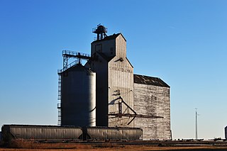
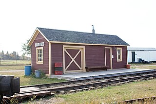
Shamrock
Location of Shamrock in Saskatchewan
Shamrock (2016 population: 20) is a village in the Canadian province of Saskatchewan within the Rural Municipality of Shamrock No. 134 and Census Division No. 7.
Shamrock (2016 population: 20) is a village in the Canadian province of Saskatchewan within the Rural Municipality of Shamrock No. 134 and Census Division No. 7.
Shamrock incorporated as a village on January 1, 1960. [1]
| Climate data for Shamrock | |||||||||||||
|---|---|---|---|---|---|---|---|---|---|---|---|---|---|
| Month | Jan | Feb | Mar | Apr | May | Jun | Jul | Aug | Sep | Oct | Nov | Dec | Year |
| Record high °C (°F) | 11.1 (52.0) | 18.0 (64.4) | 21.1 (70.0) | 31.7 (89.1) | 37.8 (100.0) | 40.5 (104.9) | 39.0 (102.2) | 39.0 (102.2) | 37.0 (98.6) | 31.1 (88.0) | 22.2 (72.0) | 11.1 (52.0) | 40.5 (104.9) |
| Mean daily maximum °C (°F) | −7.8 (18.0) | −4.6 (23.7) | 1.9 (35.4) | 11.4 (52.5) | 18.3 (64.9) | 23.2 (73.8) | 25.8 (78.4) | 25.5 (77.9) | 18.3 (64.9) | 11.7 (53.1) | 0.6 (33.1) | −6.1 (21.0) | 9.8 (49.6) |
| Daily mean °C (°F) | −12.7 (9.1) | −9.5 (14.9) | −3.4 (25.9) | 4.9 (40.8) | 11.6 (52.9) | 16.4 (61.5) | 18.7 (65.7) | 18.1 (64.6) | 11.6 (52.9) | 5.3 (41.5) | −4.4 (24.1) | −11.1 (12.0) | 3.8 (38.8) |
| Mean daily minimum °C (°F) | −17.5 (0.5) | −14.3 (6.3) | −8.7 (16.3) | −1.6 (29.1) | 4.7 (40.5) | 9.5 (49.1) | 11.6 (52.9) | 10.7 (51.3) | 4.8 (40.6) | −1.0 (30.2) | −9.3 (15.3) | −16.1 (3.0) | −2.3 (27.9) |
| Record low °C (°F) | −40.6 (−41.1) | −38.9 (−38.0) | −36.7 (−34.1) | −26.7 (−16.1) | −9.4 (15.1) | −2.8 (27.0) | 2.2 (36.0) | −1.0 (30.2) | −10 (14) | −22.5 (−8.5) | −33.0 (−27.4) | −40.5 (−40.9) | −40.6 (−41.1) |
| Average precipitation mm (inches) | 14.9 (0.59) | 15.3 (0.60) | 21.2 (0.83) | 22.1 (0.87) | 50.8 (2.00) | 64.0 (2.52) | 54.3 (2.14) | 35.7 (1.41) | 33.4 (1.31) | 13.4 (0.53) | 11.4 (0.45) | 17.2 (0.68) | 353.6 (13.92) |
| Source: Environment Canada [2] | |||||||||||||
In the 2021 Census of Population conducted by Statistics Canada, Shamrock had a population of 20 living in 12 of its 15 total private dwellings, a change of 0% from its 2016 population of 20. With a land area of 0.79 km2 (0.31 sq mi), it had a population density of 25.3/km2 (65.6/sq mi) in 2021. [5]
In the 2016 Census of Population, the Village of Shamrock recorded a population of 20 living in 12 of its 18 total private dwellings, a 0% change from its 2011 population of 20. With a land area of 0.79 km2 (0.31 sq mi), it had a population density of 25.3/km2 (65.6/sq mi) in 2016. [6]
Limerick is a village in the Canadian province of Saskatchewan within the Rural Municipality of Stonehenge No. 73 and Census Division No. 3. The village is about 150 km (94 mi) north of the US border near the towns of Lafleche and Gravelbourg. The village is named after the Irish city of Limerick.
Pilger is a village in the Canadian province of Saskatchewan within the Rural Municipality of Three Lakes No. 400 and Census Division No. 15. It is approximately 100 km (62 mi) northeast of the City of Saskatoon.
Atwater is a village in the Canadian province of Saskatchewan within the Rural Municipality of Fertile Belt No. 183 and Census Division No. 5. The village is approximately 45 kilometres (28 mi) southeast of the city of Melville on Highway 629.
Chaplin is a village in the Canadian province of Saskatchewan within the Rural Municipality of Chaplin No. 164 and Census Division No. 7. The community is situated on the Trans-Canada Highway approximately 85 km from Moose Jaw and 90 km from Swift Current. The main industries of Chaplin are Saskatchewan Minerals and farming/ranching. Chaplin consists of eight streets, two crescents, and four avenues.
Aylsham is a village in the Canadian province of Saskatchewan within the Rural Municipality of Nipawin No. 487 and Census Division No. 14. The village is approximately 65 km (40 mi) northeast of the city of Melfort.

The Rural Municipality of Shamrock No. 134 is a rural municipality (RM) in the Canadian province of Saskatchewan within Census Division No. 7 and SARM Division No. 2. Located in the south-central portion of the province, it is south of Highway 1.

Stewart Valley is a village in the Canadian province of Saskatchewan within the Rural Municipality of Saskatchewan Landing No. 167 and Census Division No. 8. It is on Highway 4, just south of the South Saskatchewan River, approximately 35 km (22 mi) north of the City of Swift Current in southern Saskatchewan. It is along the remains of the historic Swift Current-Battleford Trail.
Debden is a village in the Canadian province of Saskatchewan within the Rural Municipality of Canwood No. 494 and Census Division No. 16. The village is located on Highway 55 and is 94 kilometres (58 mi) from the city of Prince Albert and 194 kilometres (121 mi) from the city of Saskatoon. It is also the administrative headquarters of the Big River Cree First Nations band government. The village is at the edge of the Prince Albert National Park and with all the lakes nearby it becomes a popular area in the summer months.
Coderre ) is a village in the Canadian province of Saskatchewan within the Rural Municipality of Rodgers No. 133 and Census Division No. 7. The village is located approximately 85 km southwest of the City of Moose Jaw on Highway 627.
Brownlee is a village in the Canadian province of Saskatchewan within the Rural Municipality of Eyebrow No. 193 and Census Division No. 7. The village is located approximately 58 km northwest of the City of Moose Jaw on Highway 42.

Eyebrow is a village in the Canadian province of Saskatchewan within the Rural Municipality of Eyebrow No. 193 and Census Division No. 7. The community originated at the location that is now the abandoned community of Eskbank several kilometres to the south. Eyebrow is located at the intersection of Highway 367 and Highway 42; 84 km northwest of Moose Jaw, 154 km northwest of Regina and 196 km south of Saskatoon.
Buchanan is a village in the Canadian province of Saskatchewan within the Rural Municipality of Buchanan No. 304 and Census Division No. 9.

Elbow is a village in the Canadian province of Saskatchewan within the Rural Municipality of Loreburn No. 254 and Census Division No. 11. Elbow was founded in 1909, near what is now Lake Diefenbaker. It is 8 km northwest of Mistusinne, 10 km northwest of Douglas Provincial Park and 16 km southeast of Loreburn. The village got its name from its position on the elbow of the South Saskatchewan River.
Ernfold is a village in the Canadian province of Saskatchewan within the Rural Municipality of Morse No. 165 and Census Division No. 7. Initially situated alongside the original two-lane highway, the village was enclosed by the opposing lanes of the divided Trans-Canada Highway in 1973. In order to avoid complete destruction of the village the eastbound lane of the Trans-Canada Highway was rerouted approximately 3 km south of the village, leaving the village sandwiched between the Trans-Canada.
Fenwood is a village in the Canadian province of Saskatchewan within the Rural Municipality of Stanley No. 215 and Census Division No. 5.

Glenside is a village in the Canadian province of Saskatchewan within the Rural Municipality of Rudy No. 284 and Census Division No. 11. The village is located on Highway 219 approximately 10 km east of the Town of Outlook.
Parkside is a village in the Canadian province of Saskatchewan within the Rural Municipality of Leask No. 464 and Census Division No. 16.
Pennant is a village in the Canadian province of Saskatchewan within the Rural Municipality of Riverside No. 168 and Census Division No. 8.
Tugaske is a village in the Canadian province of Saskatchewan within the Rural Municipality of Huron No. 223 and Census Division No. 7. It is nicknamed Gateway to Lake Diefenbaker. It is near Eyebrow Lake, a prairie lake in the Qu'Appelle Valley. It was named after an eyebrow-shaped hill also in the Qu'Appelle Valley above Eyebrow Lake. The lake, which is 9 km long and 1 km wide, is a bird sanctuary and is near Highway 627.
Waldron is a village in the Canadian province of Saskatchewan within the Rural Municipality of Grayson No. 184 and Census Division No. 5.
50°09′36″N106°37′33″W / 50.16000°N 106.62583°W
| | This Saskatchewan location article is a stub. You can help Wikipedia by expanding it. |
