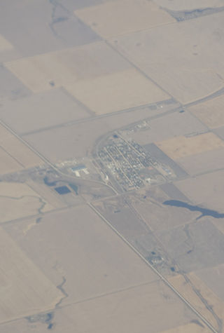
Milden is a village in the Canadian province of Saskatchewan within the Rural Municipality of Milden No. 286 and Census Division No. 12. The village is located at the junction of Highway 15 and Highway 655 approximately 20 km west of Outlook on Highway 15.

Macklin is a town in the Rural Municipality of Eye Hill No. 382, Saskatchewan, Canada. The population was 1,247 at the 2021 Canadian census. The town is located on Highway 14 and Highway 31 about 5 kilometres (3.1 mi) east of the provincial border with Alberta, and is situated near one of the most productive oil and natural gas producing fields in the province.
Waldeck is a village in the Canadian province of Saskatchewan within the Rural Municipality of Excelsior No. 166 and Census Division No. 7. Waldeck is 18 kilometres (11 mi) northeast of the city of Swift Current on the Trans-Canada Highway. Waldeck is situated in the Swift Current River Valley.
Marquis is a village in the Canadian province of Saskatchewan within the Rural Municipality of Marquis No. 191 and Census Division No. 7. It is on Highway 42 about 32 km northwest of Moose Jaw.

Herbert is a town in the Rural Municipality of Morse No. 165, in southwest Saskatchewan, Canada. The community is 48 km east of the city of Swift Current, and 197 km west of Regina, the provincial capital, on the Trans-Canada Highway. Its population as of 2016 was 856.
Lemberg is a town in Saskatchewan, Canada. It was founded by ethnic German immigrants from Lviv, for which the German name was "Lemberg", as part of the Great Economic Emigration away from Galicia and Lodomeria starting in the mid to late-1800s.
Central Butte is a town in Saskatchewan, Canada, approximately 200 kilometres (120 mi) from Saskatoon, Regina and Swift Current and 100 kilometres (62 mi) from Moose Jaw. Thunder Creek, a major tributary of the Moose Jaw River, begins west of the community. The town is served by the Central Butte Airport.
Big River is a town located on the southern end of Cowan Lake in north central Saskatchewan, Canada. It is just north of Saskatchewan's extensive grain belt on Highway 55 and about 16 kilometres (10 mi) west of Prince Albert National Park. Delaronde Lake is accessed east of the town. Big River is approximately 132 kilometres (82 mi) from Prince Albert.
Fleming is a town in Saskatchewan, Canada. Per the 2021 census, with a population of 70 inhabitants, Fleming was the smallest official town in Saskatchewan by population. It is bordered primarily by the Rural Municipality of Moosomin No. 121, but also by the Rural Municipality of Maryfield No. 91.

Francis is a town in the province of Saskatchewan in Canada. The town is 67 km southeast of Regina and 50 km north of Weyburn at the intersection of Highway 33 and Highway 35.
Richmound is a village in the Canadian province of Saskatchewan within the Rural Municipality of Enterprise No. 142 and Census Division No. 8. It is approximately 80 kilometres (50 mi) northeast of Medicine Hat, Alberta. The economy is driven in large part by the oil and gas sector as well as agriculture. The area was originally settled by Germans, mostly Catholics from South Russia.
Grand Coulee, formally Hungry Hollow, is a town in the Canadian province of Saskatchewan. It is about 18 kilometres (11 mi) west of downtown Regina. It is home to an annual event called the "Home Town Hoedown".
Hazenmore is a village in the Canadian province of Saskatchewan within the Rural Municipality of Pinto Creek No. 75 and Census Division No. 3.
Lintlaw is a village in the Canadian province of Saskatchewan within the Rural Municipality of Hazel Dell No. 335 and Census Division No. 9. The village is located at the intersection of Highway 49 and Highway 617, 142 km northwest of the City of Yorkton.

Lucky Lake is a village in the Canadian province of Saskatchewan within the Rural Municipality of Canaan No. 225 and Census Division No. 7. The Village is located at the junction of Highway 42, Highway 45 and Highway 646 approximately 90 km northeast of Swift Current, Saskatchewan.

Zealandia is a town in the Canadian province of Saskatchewan. It is one of the smallest communities in the province to be designated as a town.

Macoun is a village in the Canadian province of Saskatchewan within the Rural Municipality of Cymri No. 36 and Census Division No. 2. The village is located 28 kilometres (17 mi) northwest of the city of Estevan on Highway 39.

Conquest is a village in the Canadian province of Saskatchewan within the Rural Municipality of Fertile Valley No. 285 and Census Division No. 12.

Wymark is a hamlet in Swift Current Rural Municipality No. 137, Saskatchewan, Canada. Listed as a designated place by Statistics Canada, the hamlet had a population of 144 in the Canada 2006 Census. The hamlet is located on Highway 628 about 2 km north of Highway 363, and 15 km south of Swift Current. When the existing railway was extended to branch off in another direction, a town formed at this junction. This "Y" formation of the railway, resulted in the town being named Wymark.

Speers is a village in the Canadian province of Saskatchewan within the Rural Municipality of Douglas No. 436 and Census Division No. 16. The village is located approximately 50 kilometres (31 mi)} southeast of the City of North Battleford on Highway 40.


