Ridgedale is a village in the Canadian province of Saskatchewan within the Rural Municipality of Connaught No. 457 and Census Division No. 14. It is situated on the banks of the Carrot River.
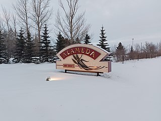
Alameda is a town in south-eastern Saskatchewan, Canada, approximately 50 kilometres (31 mi) east of Estevan. A translation of Alameda from Spanish is "Poplar Grove" or "Tree Lined Avenue". One popular story is that the town was named for Alameda, California although there is no written documentation to support this. Alameda had a population of 369 in the Canada Census of 2016.

Division No. 14 is one of eighteen census divisions in the province of Saskatchewan, Canada, as defined by Statistics Canada. It is located on the northern portion of Southeast Saskatchewan, bordering Manitoba. The most populous community in this division is the city of Melfort. Other important communities are the towns of Nipawin and Tisdale.
Love is a village in the Canadian province of Saskatchewan within the Rural Municipality of Torch River No. 488 and Census Division No. 14. The village is northeast of the City of Prince Albert and about 48 km (30 mi) south of Prince Albert National Park boundaries and 16 km (9.9 mi) south of Torch River Provincial Forest.

Leroy is a town in the province of Saskatchewan, Canada.

Stoughton is a town in Saskatchewan, Canada. In 2011 it had a population of 649. Stoughton was originally called New Hope. The tiny settlement of New Hope was barely three years old when the Canadian Pacific Railway (CPR) arrived in this part of the province in 1904. The CPR chose a location a little to the south for its closest depot, which it called Stoughton. The community of New Hope soon moved to join it.
Dilke is a village in the Canadian province of Saskatchewan within the Rural Municipality of Sarnia No. 221 and Census Division No. 6.
Duval is a village in the Canadian province of Saskatchewan within the Rural Municipality of Last Mountain Valley No. 250 and Census Division No. 11. The village is located on Highway 20 approximately 93 km north of the City of Regina.
Lang is a village in the Canadian province of Saskatchewan within the Rural Municipality of Scott No. 98 and Census Division No. 2. The village is located approximately 70 km southeast of the City of Regina.
Lintlaw is a village in the Canadian province of Saskatchewan within the Rural Municipality of Hazel Dell No. 335 and Census Division No. 9. The village is located at the intersection of Highway 49 and Highway 617, 142 km northwest of the City of Yorkton.

St. Gregor is a village in the Canadian province of Saskatchewan within the Rural Municipality of St. Peter No. 369 and Census Division No. 15. It is approximately 20 km west of the Town of Watson on Highway 5.
McTaggart is a village in the Canadian province of Saskatchewan within the Rural Municipality of Weyburn No. 67 and Census Division No. 2.
Minton is a village in the Canadian province of Saskatchewan within the Rural Municipality of Surprise Valley No. 9 and Census Division No. 2. It is on Highway 6 just north of its intersection with Highway 18, 19 km north of the Raymond-Regway Border Crossing on the Montana-Saskatchewan border. The village was named after Minton, Shropshire in England. The name was given by the Canadian Pacific Railway.
Meath Park is a village in the Canadian province of Saskatchewan within the Rural Municipality of Garden River No. 490 and Census Division No. 15.
Smeaton is a village in the Canadian province of Saskatchewan within the Rural Municipality of Torch River No. 488 and Census Division No. 14. It is at the foot of Hanson Lake Road, which ends at Creighton near Flin Flon, Manitoba). Narrow Hills Provincial Park is 70 km north.
Quinton is a village in the Canadian province of Saskatchewan within the Rural Municipality of Mount Hope No. 279 and Census Division No. 10. The village is located on Highway 15 between the Town of Raymore and the Village of Punnichy. It is near the administrative office of the Kawacatoose First Nations.
Ceylon is a village in the Canadian province of Saskatchewan within the Rural Municipality of The Gap No. 39 and Census Division No. 2. It is located alongside Gibson Creek, which is a tributary of Long Creek. No shops or businesses other than the bar remain.
Codette is a village in the Canadian province of Saskatchewan within the Rural Municipality of Nipawin No. 487 and Census Division No. 14. The village is located 10 km south of Nipawin at the junction of Highway 35 and Highway 789.
Osage is a village in the Canadian province of Saskatchewan within the Rural Municipality of Fillmore No. 96 and Census Division No. 2. The village is located on Highway 33, that runs south-east from Regina to Stoughton. The village has a grain elevator, post office, service station, and a two-sheet natural ice curling rink. Children from the area attend school in Fillmore, 13 km away. Osage celebrated its centennial in 2006.
The North Battleford Crown Colony is an unincorporated community within the Rural Municipality of North Battleford No. 437 in Saskatchewan, Canada that is designated a census subdivision by Statistics Canada. It is adjacent to the City of North Battleford and is home to the Saskatchewan Hospital North Battleford.

