
Nipawin is a town in Saskatchewan, Canada, on the Saskatchewan River portion of Tobin Lake. The town lies between Codette Lake, created by the Francois-Finlay Dam and Tobin Lake, created by the E.B. Campbell Dam built in 1963, renamed from Squaw Rapids. The construction of Francois-Finlay Dam earned Nipawin the nickname the "Town of Two Lakes".
Beatty is a village in the Canadian province of Saskatchewan within the Rural Municipality of Flett's Springs No. 429 and Census Division No. 15. The village is located approximately 13 km (8 mi) northwest of the City of Melfort. It is at the junction of Highway 3 and Highway 368. In 1925, Beatty was a Canadian National Railways (CNR) rail station on the Swan River - Prince Albert branch line. The area surrounding Beatty is predominantly farmland and the main source of employment is agriculture.

Alidaə-LEE-də is a village in the Canadian province of Saskatchewan within the Rural Municipality of Reciprocity No. 32 and Census Division No. 1. The village is approximately 85 kilometres (53 mi) east of the city of Estevan. Farming and oil are the major local industries. Several ghost towns are in the vicinity, including Nottingham to the east, Auburnton, to the west, and Cantal to the north-west. With the investment of oil and other industries, the area continues to grow.

Division No. 14 is one of eighteen census divisions in the province of Saskatchewan, Canada, as defined by Statistics Canada. It is located on the northern portion of Southeast Saskatchewan, bordering Manitoba. The most populous community in this division is the city of Melfort. Other important communities are the towns of Nipawin and Tisdale.

St. Walburg is a town in west-central Saskatchewan's prairie region on Highway 26. St. Walburg is surrounded by the Rural Municipality of Frenchman Butte No. 501. The Bronson Provincial Forest is about 10 kilometres (6.2 mi) to the north.
Semans is a village in the Canadian province of Saskatchewan within the Rural Municipality of Mount Hope No. 279 and Census Division No. 10. The village is located approximately 125 km north of the City of Regina and 195 km southeast of the City of Saskatoon.
Aylsham is a village in the Canadian province of Saskatchewan within the Rural Municipality of Nipawin No. 487 and Census Division No. 14. The village is approximately 65 km (40 mi) northeast of the city of Melfort.

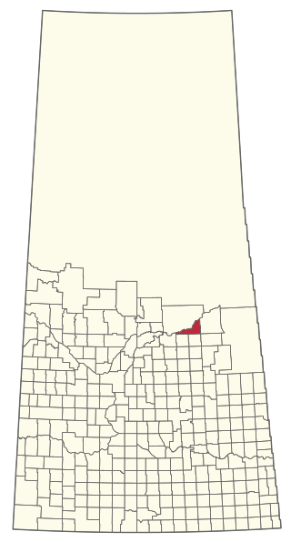
The Rural Municipality of Torch River No. 488 is a rural municipality (RM) in the Canadian province of Saskatchewan within Census Division No. 14 and SARM Division No. 4. Located in the northeast-central portion of the province, it is north of the Town of Nipawin.
Love is a village in the Canadian province of Saskatchewan within the Rural Municipality of Torch River No. 488 and Census Division No. 14. The village is northeast of the City of Prince Albert and about 48 km (30 mi) south of Prince Albert National Park boundaries and 16 km (9.9 mi) south of Torch River Provincial Forest.

Harris is a village in the Canadian province of Saskatchewan within the Rural Municipality of Harris No. 316 and Census Division No. 12. It was the site of the Great Ruby Hoax in 1914. Harris was named for Richard Elford Harris, an early settler to the area.

White Bear is an unincorporated community in the Rural Municipality of Lacadena No. 228, Saskatchewan, Canada. Listed as a designated place by Statistics Canada, the hamlet had a population of 15 in the Canada 2006 Census. The community is approximately 55 mi (89 km) northwest of Swift Current on the north side of the South Saskatchewan River.
Parry is a hamlet in the Canadian province of Saskatchewan.
Riceton is a hamlet in the Canadian province of Saskatchewan.

Shipman is a hamlet in the Canadian province of Saskatchewan.
White Fox is a village in the Canadian province of Saskatchewan within the Rural Municipality of Torch River No. 488 and Census Division No. 14. It is on Highway 55 near the White Fox River and nearly 14 km northwest of the Town of Nipawin. White Fox has a community hall for use by local residents, a public library, post office, a skating and curling facility, and a campground/RV park.
Codette is a village in the Canadian province of Saskatchewan within the Rural Municipality of Nipawin No. 487 and Census Division No. 14. The village is located 10 km south of Nipawin at the junction of Highway 35 and Highway 789.

Richard is a village in the Canadian province of Saskatchewan within the Rural Municipality of Douglas No. 436 and Census Division No. 16. It is approximately 48 km (30 mi) east of the City of North Battleford.
Spruce Lake is an unincorporated community in west-central Saskatchewan.

The Rural Municipality of Bengough No. 40 is a rural municipality (RM) in the Canadian province of Saskatchewan within Census Division No. 2 and SARM Division No. 2. It is located in the southeast portion of the province.
The Rural Municipality of Nipawin No. 487 is a rural municipality (RM) in the Canadian province of Saskatchewan within Census Division No. 14 and SARM Division No. 4.
