Division No. 13, Saskatchewan

Last updated

Division No. 13
Country Flag of Canada (Pantone).svg  Canada
Province Flag of Saskatchewan.svg  Saskatchewan
Area
  Total17,258.71 km2 (6,663.63 sq mi)
 As of 2016
Population
 (2016)
  Total23,224
  Density1.3/km2 (3.5/sq mi)

Division No. 13 is one of eighteen census divisions in the province of Saskatchewan, Canada, as defined by Statistics Canada. It is located in the western part of the province, bordering Alberta. The most populous community in this division is Kindersley.

Contents

Demographics

In the 2021 Census of Population conducted by Statistics Canada, Division No. 13 had a population of 22,047 living in 8,740 of its 10,295 total private dwellings, a change of

Knowledge of languages in Division No. 13 (1991−2021)
Language2021 [2] 2011 [3] [4] 2001 [5] [6] 1991 [7]
Pop. %Pop.%Pop.%Pop.%
English 20,69522,71023,76525,025
Tagalog 5151152025
Cree [lower-alpha 1] 510565615480
German [lower-alpha 2] 4451,2701,7202,335
French 305325525460
Spanish 125204525
Hindustani [lower-alpha 3] 9510020
Punjabi 5540025
Ukrainian 45100180210
Arabic 3010350
Chinese [lower-alpha 4] 20705570
Dutch 15308535
Polish 15207095
Portuguese 15500
Italian 10103025
Hungarian 105025
Russian 051010
Vietnamese 0500
Greek 00100
Total responses20,74022,78023,77525,085
Total population22,04723,08924,05425,388

Census subdivisions

The following census subdivisions (municipalities or municipal equivalents) are located within Saskatchewan's Division No. 13.

Towns

Villages

Rural municipalities

  • RM No. 290 Kindersley
  • RM No. 292 Milton
  • RM No. 319 Winslow
  • RM No. 320 Oakdale
  • RM No. 321 Prairiedale
  • RM No. 322 Antelope Park
  • RM No. 349 Grandview
  • RM No. 350 Mariposa
  • RM No. 351 Progress
  • RM No. 352 Heart's Hill
  • RM No. 379 Reford
  • RM No. 380 Tramping Lake
  • RM No. 381 Grass Lake
  • RM No. 382 Eye Hill
  • RM No. 409 Buffalo
  • RM No. 410 Round Valley
  • RM No. 411 Senlac
  • RM No. 439 Cut Knife
  • RM No. 440 Hillsdale
  • RM No. 442 Manitou Lake

[8]

Indian reserves

[8]

See also

Notes

  1. Combined responses of the Cree-Innu languages, previously categorized under "Cree" in past censuses.
  2. Combined responses of the High German languages, including Standard German, Pennsylvania German, Swiss German, and Yiddish.
  3. Combined responses of Hindi and Urdu as they form mutually intelligible registers of the Hindustani language.
  4. Combined responses of the Chinese languages, including Mandarin, Cantonese, Min Nan, Hakka, Wu (Shanghainese), Min Dong, Chinese, n.o.s., and Chinese languages, n.i.e..

Related Research Articles

<span class="mw-page-title-main">Cowichan Valley Regional District</span> Regional district in British Columbia, Canada

The Cowichan Valley Regional District is a regional district in the Canadian province of British Columbia is on the southern part of Vancouver Island, bordered by the Nanaimo and Alberni-Clayoquot Regional Districts to the north and northwest, and by the Capital Regional District to the south and east. As of the 2021 Census, the Regional District had a population of 89,013. The regional district offices are in Duncan.

<span class="mw-page-title-main">Division No. 2, Saskatchewan</span> Census division of Saskatchewan, Canada

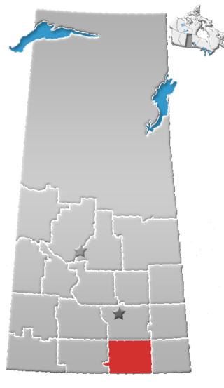
Division No. 2 is one of eighteen census divisions in the province of Saskatchewan, Canada, as defined by Statistics Canada. It is located in the south-southeastern part of the province, on the United States border. The most populous community in this division is Weyburn.

<span class="mw-page-title-main">Division No. 1, Saskatchewan</span> Census division of Saskatchewan, Canada

Division No. 1 is one of eighteen census divisions in the province of Saskatchewan, Canada, as defined by Statistics Canada. It is located in the southeast corner of the province, bordering Manitoba and North Dakota. The most populous community in this division is Estevan.

<span class="mw-page-title-main">Division No. 3, Saskatchewan</span> Census division of Saskatchewan, Canada

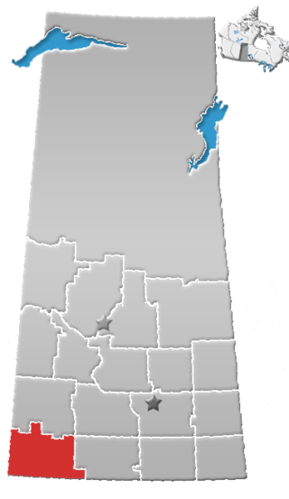
Division No. 3 is one of eighteen census divisions in the province of Saskatchewan, Canada, as defined by Statistics Canada. It is located in the south-southwestern part of the province, adjacent to the border with Montana, United States. The most populous community in this division is Assiniboia.

<span class="mw-page-title-main">Division No. 4, Saskatchewan</span> Census division of Saskatchewan, Canada

Division No. 4 is one of eighteen census divisions in the province of Saskatchewan, Canada, as defined by Statistics Canada. It is located in the southwest corner of the province, bordering Alberta to the west and Montana, United States to the south. The most populous community in this division is Maple Creek.

<span class="mw-page-title-main">Division No. 5, Saskatchewan</span> Census division of Saskatchewan, Canada

Division No. 5 is one of eighteen census divisions in the province of Saskatchewan, Canada, as defined by Statistics Canada. It is located in the east-southeastern part of the province, bordering Manitoba. The most populous community in this division is Melville.

<span class="mw-page-title-main">Division No. 6, Saskatchewan</span> Census division of Saskatchewan, Canada

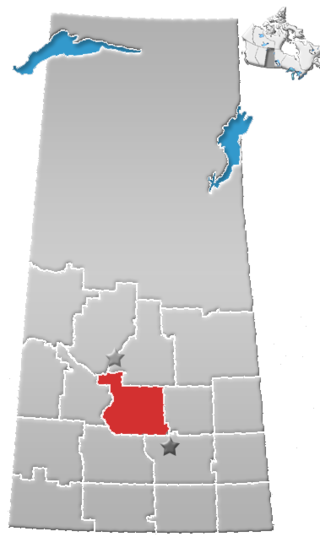
Division No. 6 is one of eighteen census divisions in the province of Saskatchewan, Canada, as defined by Statistics Canada. It is located in the south-central part of the province. The most populous community in this division is Regina, the provincial capital.

<span class="mw-page-title-main">Division No. 7, Saskatchewan</span> Census division of Saskatchewan, Canada

Division No. 7 is one of eighteen census divisions in the province of Saskatchewan, Canada, as defined by Statistics Canada. It is located in the south-central part of the province. The most populous community in this division is Moose Jaw.

<span class="mw-page-title-main">Division No. 8, Saskatchewan</span> Census division of Saskatchewan, Canada

Division No. 8 is one of eighteen census divisions in the province of Saskatchewan, Canada, as defined by Statistics Canada. It is located in the west-southwestern part of the province, bordering Alberta. The most populous community in this division is Swift Current.

<span class="mw-page-title-main">Division No. 9, Saskatchewan</span> Census division of Saskatchewan, Canada

Division No. 9, Canada, is one of the eighteen census divisions within the province of Saskatchewan, as defined by Statistics Canada. It is located in the eastern part of the province, bordering Manitoba. The most populous community in this division is Yorkton.

<span class="mw-page-title-main">Division No. 10, Saskatchewan</span> Census division of Saskatchewan, Canada

Division No. 10 is one of eighteen census divisions in the province of Saskatchewan, Canada, as defined by Statistics Canada. It is located in the east-central part of the province. The most populous community in this division is Wynyard.

<span class="mw-page-title-main">Division No. 11, Saskatchewan</span> Census division of Saskatchewan, Canada

Division No. 11 is one of eighteen census divisions in the province of Saskatchewan, Canada, as defined by Statistics Canada. It is located in the central part of the province and includes the largest city in the province, Saskatoon.

<span class="mw-page-title-main">Division No. 12, Saskatchewan</span> Census division of Saskatchewan, Canada

Division No. 12 is one of the eighteen census divisions in the province of Saskatchewan, Canada, as defined by Statistics Canada. It is located in the west-central part of the province. The most populous community in this division is Battleford.

<span class="mw-page-title-main">Demographics of Saskatchewan</span>

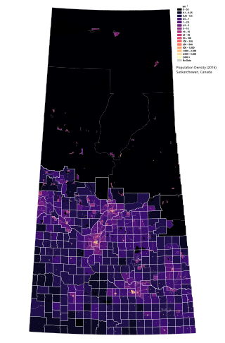
Saskatchewan is the middle province of Canada's three Prairie provinces. It has an area of 651,900 km² (251,700 mi²) and a population of 1,132,505 (Saskatchewanians) as of 2021. Saskatchewan's population is made of 50.3% women and 49.7% men. Most of its population lives in the Southern half of the province.

<span class="mw-page-title-main">Demographics of Newfoundland and Labrador</span>

Newfoundland and Labrador is a province of Canada on the country's Atlantic coast in northeastern North America. The province has an area of 405,212 square kilometres and a population in 2023 of 533,710, with approximately 95% of the provincial population residing on the Island of Newfoundland, with more than half of the population residing on the Avalon Peninsula. People from Newfoundland and Labrador are called "Newfoundlanders," "Labradorians", or "Newfoundlanders and Labradorians".

<span class="mw-page-title-main">Demographics of Nova Scotia</span> Demographics of region

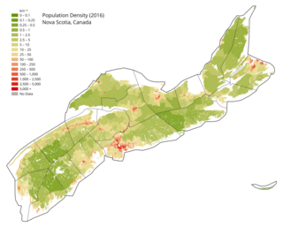
Nova Scotia is a Canadian province located on the country's southeastern coast. It is the most populous province in Atlantic Canada, and its capital, Halifax, is a major economic centre of the region. Geographically, Nova Scotia is the second smallest province in Canada, with an area of 52,824.71 km2 (20,395.73 sq mi). As of 2021, it has a population of 969,383 people.

The Northwest Territories is a territory of Canada. It has an area of 1,171,918 square kilometres and a population of 41,786 as of the 2016 Canadian census.

Lake Cowichan is a town located on the east end of Cowichan Lake and, by highway, is 27 kilometres (17 mi) west of Duncan, British Columbia. The town of Lake Cowichan was incorporated in 1944. The Cowichan River flows through the middle of the town. Cowichan River is designated as a Heritage River.

According to the 2021 census, the City of Edmonton had a population of 1,010,899 residents, compared to 4,262,635 for all of Alberta, Canada. The total population of the Edmonton census metropolitan area (CMA) was 1,418,118, making it the sixth-largest CMA in Canada.

<span class="mw-page-title-main">Demographics of Calgary</span>

In the 2021 Census, the City of Calgary had a population of 1,306,784 residents, representing 30.7% of the 4,262,635 residents in all of Alberta, and 3.5% compared to a population of 36,991,981 in all of Canada. The total population of the Calgary census metropolitan area (CMA) was 1,481,806. Calgary is the largest city in Alberta, and the third-largest municipality and fifth-largest metropolitan area in Canada, as of 2021.

References

  1. "Population and dwelling counts: Canada and census divisions". Statistics Canada. 9 February 2022. Retrieved 2 April 2022.
  2. Government of Canada, Statistics Canada (17 August 2022). "Knowledge of languages by age and gender: Canada, provinces and territories, census divisions and census subdivisions". www12.statcan.gc.ca. Retrieved 15 July 2023.
  3. Government of Canada, Statistics Canada (27 November 2015). "NHS Profile". www12.statcan.gc.ca. Retrieved 15 July 2023.
  4. Government of Canada, Statistics Canada (31 May 2016). "Census Profile". www12.statcan.gc.ca. Retrieved 15 July 2023.
  5. Government of Canada, Statistics Canada (23 December 2013). "2001 Census Topic-based tabulations Various Non-official Languages Spoken (76), Age Groups (13) and Sex (3) for Population, for Canada, Provinces, Territories, Census Divisions and Census Subdivisions, 2001 Census - 20% Sample Data". www12.statcan.gc.ca. Retrieved 15 July 2023.
  6. Government of Canada, Statistics Canada (23 December 2013). "2001 Census Topic-based tabulations Knowledge of Official Languages (5), Age Groups (13) and Sex (3) for Population, for Canada, Provinces, Territories, Census Divisions and Census Subdivisions, 2001 Census - 20% Sample Data". www12.statcan.gc.ca. Retrieved 15 July 2023.
  7. Government of Canada, Statistics Canada (29 March 2019). "1991 Census Area Profiles Profile of Census Divisions and Subdivisions - Part B". www12.statcan.gc.ca. Retrieved 15 July 2023.
  8. 1 2 Statistics Canada. 2002 2001 Community Profiles. Archived 2005-12-22 at the Wayback Machine Released June 27, 2002. Last modified: 2005-11-30. Statistics Canada Catalogue no. 93F0053XIE. Page accessed January 5, 2007

51°28′00″N109°09′21″W / 51.46667°N 109.15583°W / 51.46667; -109.15583