The Cowichan Valley Regional District is a regional district in the Canadian province of British Columbia is on the southern part of Vancouver Island, bordered by the Nanaimo and Alberni-Clayoquot Regional Districts to the north and northwest, and by the Capital Regional District to the south and east. As of the 2021 Census, the Regional District had a population of 89,013. The regional district offices are in Duncan.
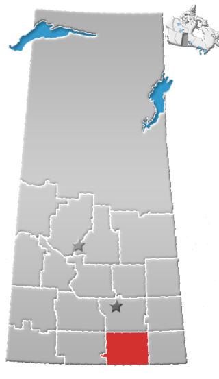
Division No. 2 is one of eighteen census divisions in the province of Saskatchewan, Canada, as defined by Statistics Canada. It is located in the south-southeastern part of the province, on the United States border. The most populous community in this division is Weyburn.

Division No. 1 is one of eighteen census divisions in the province of Saskatchewan, Canada, as defined by Statistics Canada. It is located in the southeast corner of the province, bordering Manitoba and North Dakota. The most populous community in this division is Estevan.

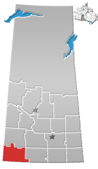
Division No. 3 is one of eighteen census divisions in the province of Saskatchewan, Canada, as defined by Statistics Canada. It is located in the south-southwestern part of the province, adjacent to the border with Montana, United States. The most populous community in this division is Assiniboia.
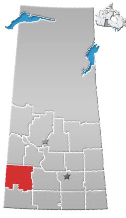
Division No. 4 is one of eighteen census divisions in the province of Saskatchewan, Canada, as defined by Statistics Canada. It is located in the southwest corner of the province, bordering Alberta to the west and Montana, United States to the south. The most populous community in this division is Maple Creek.

Division No. 5 is one of eighteen census divisions in the province of Saskatchewan, Canada, as defined by Statistics Canada. It is located in the east-southeastern part of the province, bordering Manitoba. The most populous community in this division is Melville.

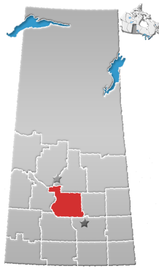
Division No. 6 is one of eighteen census divisions in the province of Saskatchewan, Canada, as defined by Statistics Canada. It is located in the south-central part of the province. The most populous community in this division is Regina, the provincial capital.

Division No. 7 is one of eighteen census divisions in the province of Saskatchewan, Canada, as defined by Statistics Canada. It is located in the south-central part of the province. The most populous community in this division is Moose Jaw.

Division No. 9, Canada, is one of the eighteen census divisions within the province of Saskatchewan, as defined by Statistics Canada. It is located in the eastern part of the province, bordering Manitoba. The most populous community in this division is Yorkton.

Division No. 10 is one of eighteen census divisions in the province of Saskatchewan, Canada, as defined by Statistics Canada. It is located in the east-central part of the province. The most populous community in this division is Wynyard.
Division No. 11 is one of eighteen census divisions in the province of Saskatchewan, Canada, as defined by Statistics Canada. It is located in the central part of the province and includes the largest city in the province, Saskatoon.

Division No. 12 is one of the eighteen census divisions in the province of Saskatchewan, Canada, as defined by Statistics Canada. It is located in the west-central part of the province. The most populous community in this division is Battleford.

Division No. 13 is one of eighteen census divisions in the province of Saskatchewan, Canada, as defined by Statistics Canada. It is located in the western part of the province, bordering Alberta. The most populous community in this division is Kindersley.
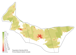
Prince Edward Island is a Canadian province. According to the 2011 National Household Survey, the largest ethnic group consists of people of Scottish descent (39.2%), followed by English (31.1%), Irish (30.4%), French (21.1%), German (5.2%), and Dutch (3.1%) descent. Prince Edward Island is mostly a white community and there are few visible minorities. Chinese people are the largest visible minority group of Prince Edward Island, comprising 1.3% of the province's population. Almost half of respondents identified their ethnicity as "Canadian." Prince Edward Island is by a strong margin the most Celtic and specifically the most Scottish province in Canada and perhaps the most Scottish place (ethnically) in the world, outside Scotland. 38% of islanders claim Scottish ancestry, but this is an underestimate and it is thought that almost 50% of islanders have Scottish roots. When combined with Irish and Welsh, almost 80% of islanders are of some Celtic stock, albeit most families have resided in PEI for at least two centuries. Few places outside Europe can claim such a homogeneous Celtic ethnic background. The only other jurisdiction in North America with such a high percentage of British Isles heritage is Newfoundland.
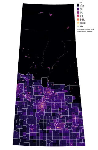
Saskatchewan is the middle province of Canada's three Prairie provinces. It has an area of 651,900 km² (251,700 mi²) and a population of 1,132,505 (Saskatchewanians) as of 2021. Saskatchewan's population is made of 50.3% women and 49.7% men. Most of its population lives in the Southern half of the province.
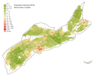
Nova Scotia is a Canadian province located on the country's southeastern coast. It is the most populous province in Atlantic Canada, and its capital, Halifax, is a major economic centre of the region. Geographically, Nova Scotia is the second smallest province in Canada, with an area of 52,824.71 km2 (20,395.73 sq mi). As of 2021, it has a population of 969,383 people.
Lake Cowichan is a town located on the east end of Cowichan Lake and, by highway, is 27 kilometres (17 mi) west of Duncan, British Columbia. The town of Lake Cowichan was incorporated in 1944. The Cowichan River flows through the middle of the town. Cowichan River is designated as a Heritage River.
According to the 2021 census, the City of Edmonton had a population of 1,010,899 residents, compared to 4,262,635 for all of Alberta, Canada. The total population of the Edmonton census metropolitan area (CMA) was 1,418,118, making it the sixth-largest CMA in Canada.

The Saskatoon region is the greater metropolitan area of Saskatoon, Saskatchewan. As of 2021 the Statistics Canada estimates the region's population to be 317,480 people.

In the 2021 Census, the City of Calgary had a population of 1,306,784 residents, representing 30.7% of the 4,262,635 residents in all of Alberta, and 3.5% compared to a population of 36,991,981 in all of Canada. The total population of the Calgary census metropolitan area (CMA) was 1,481,806. Calgary is the largest city in Alberta, and the third-largest municipality and fifth-largest metropolitan area in Canada, as of 2021.