Melfort is a city in Saskatchewan, Canada, located approximately 95 kilometres (59 mi) southeast of Prince Albert, 172 kilometres (107 mi) northeast of Saskatoon and 280 kilometres (170 mi) north of Regina.
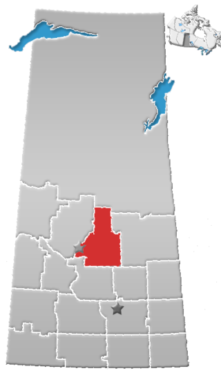
Kelvington-Wadena is a provincial electoral district for the Legislative Assembly of Saskatchewan, Canada, in the east-central region.

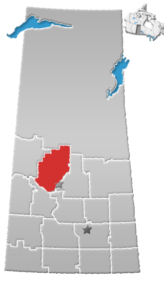
Carrot River Valley is a provincial electoral district for the Legislative Assembly of Saskatchewan, Canada. Located in the east central area of Saskatchewan, this constituency was created by The Representation Act, 1994 (Saskatchewan) out of the former district of Kelsey-Tisdale and part of the riding of Nipawin. The Carrot River flows through the riding.

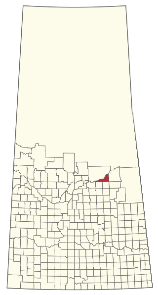
The Rural Municipality of Tisdale No. 427 is a rural municipality (RM) in the Canadian province of Saskatchewan within Census Division No. 14 and SARM Division No. 4. It is located in the northeast-central portion of the province.
Arborfield is a town in east-central Saskatchewan, Canada, approximately 70 km (43 mi) north-east of Melfort. The town is located on Highway 23 14 km (8.7 mi) west of the Pasquia Hills. Arborfield is approximately 54 km (34 mi) from Nipawin, 53 km (33 mi) from Tisdale, 266 km (165 mi) from Saskatoon, and 196 km (122 mi) from Prince Albert.
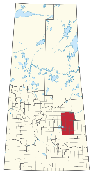
SARM Division No. 4 is a division of the Saskatchewan Association of Rural Municipalities (SARM) within the Canadian province of Saskatchewan. It is located in the north-east area of the province. There are 43 rural municipalities in this division. The current director for Division 4 is Myron Kopec.
Division No. 15 is one of eighteen census divisions in the province of Saskatchewan, Canada, as defined by Statistics Canada. It is located in the north-central part of the province. The most populous community in this division is Prince Albert.
Division No. 16 is one of eighteen census divisions in the province of Saskatchewan, Canada, as defined by Statistics Canada. It is located in the north-central part of the province. The most populous community in this division is North Battleford.
Aylsham is a village in the Canadian province of Saskatchewan within the Rural Municipality of Nipawin No. 487 and Census Division No. 14. The village is approximately 65 km (40 mi) northeast of the city of Melfort.

The Rural Municipality of Flett's Springs No. 429 is a rural municipality (RM) in the Canadian province of Saskatchewan within Census Division No. 15 and SARM Division No. 5.

Highway 35 is a paved undivided provincial highway in the Canadian province of Saskatchewan.. It runs from the US Border near Port of Oungre to a dead end near the north shore of Tobin Lake. Saskatchewan Highway 35 (SK Hwy 35) is about 569 kilometres (354 mi) long. The CanAm Highway comprises Saskatchewan Highways 35, SK Hwy 39, SK Hwy 6, SK Hwy 3, SK Hwy 2 and U.S. Route 85. 74.6 kilometres (46.4 mi) of SK Hwy 35 contribute to the CanAm Highway between Port of Oungre on the Canada – United States border and Weyburn. Mudslides, and spring flooding were huge road building and maintenance problems around Nipawin as well as along the southern portion of the route named the Greater Yellow Grass Marsh. Over 20 early dams were built until the problem was addressed with the Rafferty-Alameda Project on the Souris River and the construction of the Qu'Appelle River Dam which have helped to eliminate washed out roads and flooded communities. The highway through the homesteading community followed the Dominion Land Survey on the square until reaching the Saskatchewan River at Nipawin. The completion of the combined railway and traffic bridge over the Saskatchewan River at Nipawin in the late 1920s retired the ferry and basket crossing for traffic north of Nipawin. The E.B. Campbell Dam built in 1963 northeast of Nipawin created Tobin Lake, and Codette Lake was formed with the construction of the Francois-Finlay Hydroelectric dam at Nipawin. The railway/traffic bridge that formed part of Highway 35 was the only crossing utilized at Nipawin until a new traffic bridge was constructed in 1974. The new bridge then became part of the combined Highway 35 and 55 until the highway parts just east of White Fox. Highway 35 then continued north along the west side of Tobin Lake. The railway/traffic bridge continues to be utilized for one lane vehicle traffic controlled by traffic lights, and continues as the "old highway 35" on the west side of the river until it joins with the current Highway 35/55.

Carrot River is a river in Western Canada in the north-eastern part Saskatchewan and the north-western part of Manitoba. The outlet of Wakaw Lake in Saskatchewan marks the beginning of the Carrot River and, from there, it flows north-east past several communities and Indian reserves until it joins the Saskatchewan River in the Cumberland Delta in Manitoba. The river's mouth is west and upstream of the Pasquia River and The Pas on the Saskatchewan River.

The Rural Municipality of Kelvington No. 366 is a rural municipality (RM) in the Canadian province of Saskatchewan within Census Division No. 14 and SARM Division No. 4. It is located in the southeast portion of the province.
Bjorkdale is a village in the Canadian province of Saskatchewan within the Rural Municipality of Bjorkdale No. 426 and Census Division No. 14. The village is located at the junctions of Highway 23, 679 & 776, approximately 78 kilometres (48 mi) east of the City of Melfort.
Codette is a village in the Canadian province of Saskatchewan within the Rural Municipality of Nipawin No. 487 and Census Division No. 14. The village is located 10 km south of Nipawin at the junction of Highway 35 and Highway 789.

The Rural Municipality of Willow Creek No. 458 is a rural municipality (RM) in the Canadian province of Saskatchewan within Census Division No. 14 and SARM Division No. 4.

The Rural Municipality of Moose Range No. 486 is a rural municipality (RM) in the Canadian province of Saskatchewan within Census Division No. 14 and SARM Division No. 4.
The Rural Municipality of Nipawin No. 487 is a rural municipality (RM) in the Canadian province of Saskatchewan within Census Division No. 14 and SARM Division No. 4.

The Rural Municipality of Pleasantdale No. 398 is a rural municipality (RM) in the Canadian province of Saskatchewan within Census Division No. 14 and SARM Division No. 4.

