Balgonie is a town in southeast Saskatchewan. Situated at the intersection of Highways 10, 46, and the Trans-Canada Highway, the town is part of the White Butte region and neighbours Pilot Butte, White City, and McLean. As well, it is located 25 kilometres east of the province's capital city, Regina. As of the 2016 census, Balgonie had a population of 1,765, an 8.3% growth from 2011. The town is governed by the Balgonie Town Council and is surrounded by the Rural Municipality of Edenwold No. 158. Balgonie is located in Treaty 4 territory.

Wakaw, Saskatchewan, is a town 90 kilometres (56 mi) northeast of Saskatoon and 66 kilometres (41 mi) south of Prince Albert. It is about halfway between the two cities and is served by Highway 2, Highway 41, and Highway 312. Wakaw is in hilly partially forested country east of the South Saskatchewan River. The area is part of the aspen parkland biome.
Cut Knife is a town located in the Canadian province of Saskatchewan on Highway 40, northwest of Saskatoon and 55 km west of North Battleford. The population of Cut Knife in 2011 was 517.
Punnichy is a village in the Canadian province of Saskatchewan within the Rural Municipality of Mount Hope No. 279 and Census Division No. 10. It is 126 km (78 mi) northeast of the City of Regina. This village is part of the original "Alphabet Line" of the main Canadian National Railway line with Lestock to the east and Quinton to the west. Punnichy derived its name from panacay, "fledgling bird with few feathers", a Saulteaux joke referring to the appearance of a pioneer merchant.
Strasbourg is a town in the Canadian province of Saskatchewan. It is about 75 kilometres (47 mi) northwest of the provincial capital, Regina.
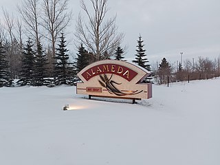
Alameda is a town in south-eastern Saskatchewan, Canada, approximately 50 kilometres (31 mi) east of Estevan. A translation of Alameda from Spanish is "Poplar Grove" or "Tree Lined Avenue". One popular story is that the town was named for Alameda, California although there is no written documentation to support this. Alameda had a population of 369 in the Canada Census of 2016.

Asquith is a town in south-central Saskatchewan, Canada, approximately 38 kilometres (24 mi) west of Saskatoon. It became a village in December 1907. According to the 2011 Census, its population is 603.

Regina Beach is a town in south central Saskatchewan, located on Highway 54, close to where Highway 11 intersects with the Qu'Appelle Valley.

Division No. 6 is one of eighteen census divisions in the province of Saskatchewan, Canada, as defined by Statistics Canada. It is located in the south-central part of the province. The most populous community in this division is Regina, the provincial capital.

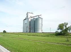
Elrose is a town located just to the north of the Coteau Hills. It is south of Rosetown and north of Swift Current on Highway 4 and Highway 44. A community in the middle of an agricultural economy, Elrose has also become a local hub of activity in the oil industry. The town is surrounded by the Rural Municipality of Monet No. 257.

Belle Plaine is a village in the Canadian province of Saskatchewan within the Rural Municipality of Pense No. 160 and Census Division No. 6. Belle Plaine is located on Highway 1, 21 kilometres east of the City of Moose Jaw in south-central Saskatchewan. Buffalo Pound Provincial Park and Regina Beach are located near Belle Plaine.
Rose Valley is a town in the rural municipality of Ponass Lake No. 367, in the Canadian province of Saskatchewan. Rose Valley is located at the intersection of Highway 35 and Primary Grid 746 in east-central Saskatchewan. Wheat and dairy are the main economic industries in the area.

Herbert is a town in the Rural Municipality of Morse No. 165, in southwest Saskatchewan, Canada. The community is 48 km east of the city of Swift Current, and 197 km west of Regina, the provincial capital, on the Trans-Canada Highway. Its population as of 2016 was 856.

Stoughton is a town in Saskatchewan, Canada. In 2011 it had a population of 649. Stoughton was originally called New Hope. The settlement of New Hope was barely three years old when the Canadian Pacific Railway (CPR) arrived in this part of the province in 1904. The CPR chose a location a little to the south for its closest depot, which it called Stoughton. The community of New Hope soon moved to join it.

Francis is a town in the province of Saskatchewan in Canada. The town is 67 km southeast of Regina and 50 km north of Weyburn at the intersection of Highway 33 and Highway 35.

The Rural Municipality of Pense No. 160 is a rural municipality (RM) in the Canadian province of Saskatchewan within Census Division No. 6 and SARM Division No. 2. It is located in the southeast portion of the province.
Grand Coulee, formally Hungry Hollow, is a town in the Canadian province of Saskatchewan. It is about 18 kilometres (11 mi) west of downtown Regina. It is home to an annual event called the "Home Town Hoedown".
Mantario is a special service area in the Rural Municipality of Chesterfield No. 261 in the Canadian province of Saskatchewan.It held village status prior to June 30, 2007. The population was five people in 2011. The community is located 70 kilometres (43 mi) southwest of the town of Kindersley on Highway 44.
Senlac is a village in the Canadian province of Saskatchewan within the Rural Municipality of Senlac No. 411 and Census Division No. 13. The village was named after Senlac Hill, the location of the Battle of Hastings in England in 1066.

Torquay is a village in the Canadian province of Saskatchewan within the Rural Municipality of Cambria No. 6 and Census Division No. 2. It was named after Torquay in Devon, England.