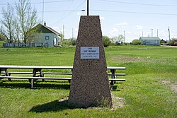
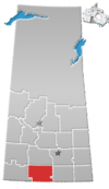
Limerick is a village in the Canadian province of Saskatchewan within the Rural Municipality of Stonehenge No. 73 and Census Division No. 3. The village is about 150 km (94 mi) north of the US border near the towns of Lafleche and Gravelbourg. The village is named after the Irish city of Limerick.

Simpson is a village in the Canadian province of Saskatchewan within the Rural Municipality of Wood Creek No. 281 and Census Division No. 11. It is between the cities of Regina and Saskatoon on Highway 2. The administrative office for the Rural Municipality of Wood Creek No. 281 is located in the village. The post office was founded in 1911 by Herman Bergren and Joseph Newman during construction of the Canadian Pacific Railway. It is named after George Simpson, a governor of the Hudson's Bay Company.

Admiral is a special service area within the Rural Municipality of Wise Creek No. 77 in Saskatchewan, Canada. Originally incorporated as a village in 1914, it relinquished its status when it dissolved on August 17, 2006.

Division No. 3 is one of eighteen census divisions in the province of Saskatchewan, Canada, as defined by Statistics Canada. It is located in the south-southwestern part of the province, adjacent to the border with Montana, United States. The most populous community in this division is Assiniboia.

Hodgeville is a village in the Canadian province of Saskatchewan within the Rural Municipality of Lawtonia No. 135 and Census Division No. 7. The village is located approximately 34 km south of the Trans Canada Highway, 97 km southeast of the City of Swift Current.
Heward is a village in the Canadian province of Saskatchewan within the Rural Municipality of Tecumseh No. 65 and Census Division No. 1. The village is located along highway 33 in southeastern Saskatchewan. Even though it has under 50 people it still maintains a post office, rink, and hall that all service the farming community. In 1977 Prairie Trails and Tales: Heward Saskatchewan 1900-1976 was written by Muriel Dempsey.

Bladworth is a village in the Canadian province of Saskatchewan within the Rural Municipality of McCraney No. 282 and Census Division No. 11. The village is located 99 kilometres (62 mi) south of the City of Saskatoon on Highway 11.
Brownlee is a village in the Canadian province of Saskatchewan within the Rural Municipality of Eyebrow No. 193 and Census Division No. 7. The village is located approximately 58 km northwest of the City of Moose Jaw on Highway 42.

Eyebrow is a village in the Canadian province of Saskatchewan within the Rural Municipality of Eyebrow No. 193 and Census Division No. 7. The community originated at the location that is now the abandoned community of Eskbank several kilometres to the south. Eyebrow is located at the intersection of Highway 367 and Highway 42; 84 km northwest of Moose Jaw, 154 km northwest of Regina and 196 km south of Saskatoon.
Duff is a special service area in the Canadian province of Saskatchewan within the Rural Municipality (RM) of Stanley No. 215 and Census Division No. 5. It is approximately 122 kilometres (76 mi) northeast of the City of Regina, 66 kilometres (41 mi) southwest of Yorkton and 20 kilometres (12 mi) west of Melville.

Glenside is a village in the Canadian province of Saskatchewan within the Rural Municipality of Rudy No. 284 and Census Division No. 11. The village is located on Highway 219 approximately 10 km east of the Town of Outlook.
Hazenmore is a village in the Canadian province of Saskatchewan within the Rural Municipality of Pinto Creek No. 75 and Census Division No. 3.

Lang is a village in the Canadian province of Saskatchewan within the Rural Municipality of Scott No. 98 and Census Division No. 2. The village is located approximately 70 km southeast of the City of Regina.

St. Gregor is a village in the Canadian province of Saskatchewan within the Rural Municipality of St. Peter No. 369 and Census Division No. 15. It is approximately 20 km west of the Town of Watson on Highway 5.
McTaggart is a village in the Canadian province of Saskatchewan within the Rural Municipality of Weyburn No. 67 and Census Division No. 2.

Meacham is a village in the Canadian province of Saskatchewan within the Rural Municipality of Colonsay No. 342 and Census Division No. 11. It is located 69 kilometres east of the City of Saskatoon on Highway 2.

Viscount is a village in the Canadian province of Saskatchewan within the Rural Municipality of Viscount No. 341 and Census Division No. 11. Viscount is located on Saskatchewan Highway 16, the Yellowhead Highway, in central Saskatchewan east of Colonsay and west of Lanigan. As of the Canada 2016 Census, Viscount had a population of 232.

Wood Mountain is a village in the Canadian province of Saskatchewan within the Rural Municipality of Old Post No. 43 and Census Division No. 3. Its name is derived from the Red River Métis words "montagne de bois", due to the abundance of poplar trees in the otherwise barren region. Highway 18 and Highway 358 intersect south of the community.

The Rural Municipality of Pinto Creek No. 75 is a rural municipality (RM) in the Canadian province of Saskatchewan within Census Division No. 3 and SARM Division No. 3. It is located in the southern portion of the province.

The Rural Municipality of Miry Creek No. 229 is a rural municipality (RM) in the Canadian province of Saskatchewan within Census Division No. 8 and SARM Division No. 3.


